FAA INFORMATION EFFECTIVE 30 OCTOBER 2025
Location
| FAA Identifier: | 0C5 |
| Lat/Long: | 43-34-37.2400N 085-17-02.4000W
43-34.620667N 085-17.040000W
43.5770111,-85.2840000
(estimated) |
| Elevation: | 960 ft. / 293 m (estimated) |
| Variation: | 04W (1985) |
| From city: | 5 miles SW of MECOSTA, MI |
| Time zone: | UTC -5 (UTC -4 during Daylight Saving Time) |
| Zip code: | 49346 |
Airport Operations
| Airport use: | Open to the public |
| Control tower: | no |
| ARTCC: | CHICAGO CENTER |
| FSS: | LANSING FLIGHT SERVICE STATION |
| NOTAMs facility: | LAN (NOTAM-D service available) |
| Attendance: | UNATNDD |
| Wind indicator: | yes |
| Segmented circle: | no |
| Lights: | RWY LGTS SS-SR APR-NOV. |
Airport Communications
| CTAF: | 122.9 |
| WX AWOS-3P at RQB (13 nm NW): | 125.875 (231-796-0884) |
Nearby radio navigation aids
| VOR radial/distance | | VOR name | | Freq | | Var |
|---|
| MOPr268/23.9 | | MOUNT PLEASANT VOR/DME | | 110.60 | | 05W |
Airport Services
Runway Information
Runway 18/36
| Dimensions: | 3800 x 100 ft. / 1158 x 30 m |
| Surface: | turf, in good condition |
| Runway edge lights: | low intensity |
| RUNWAY 18 | | RUNWAY 36 |
| Latitude: | 43-34.933333N | | 43-34.308000N |
| Longitude: | 085-17.041667W | | 085-17.038333W |
| Elevation: | 960.0 ft. | | 960.0 ft. |
| Traffic pattern: | left | | left |
| Runway heading: | 184 magnetic, 180 true | | 004 magnetic, 000 true |
| Displaced threshold: | 955 ft.
DTHR MKD WITH LGTD CONES. | | 385 ft.
DTHR MKD WITH LGTD CONES. |
| Obstructions: | 15 ft. road, 97 ft. left of centerline
APCH RATIO 0:1 AT DTHR OVR +15 FT ROAD, 0 FT DIST, 90 FT L; 3:1 OVR +30 FT TREE, 90 FT DIST, 134 FT R; 16:1 BASED ON STRAIGHT OUT OVR +65 FT TREES, 1100 DIST. | | 15 ft. road, 90 ft. right of centerline
APCH RATIO 25:1 OVR 16 FT HNGR, 372 FT DIST, 50 FT L; 17:1 AT DTHR OVR +57 FT TREES, 994 FT DIST. |
Airport Ownership and Management from official FAA records
| Ownership: | Privately-owned |
| Owner: | CANADIAN LAKES PROPERTY OWNERS CORP
10690 PIERCE RD
STANWOOD, MI 49346-9098
Phone 231-972-7651 |
| Manager: | LOUIS WEIJERS
7396 CESSNA LN
STANWOOD, MI 49346-9387
Phone 231-972-7821
CELL 231-692-9599. |
Additional Remarks
| - | +3 FT FENCE ENTR LEN RWY 18/36, 114 FT WEST. |
| - | DEPS FLY RWY HDG TO 1500 FT MSL FOR NOISE ABATEMENT. |
| - | FOR CD CTC GREAT LAKES APCH AT 269-459-3344, WHEN APCH CLSD CTC CHICAGO ARTCC AT 630-906-8921. |
| - | NO SNOW REMOVAL - FOR FLD CONDS CALL AMGR OR AMGR CELL. |
| - | DEER ON & INVOF ARPT. |
Instrument Procedures
There are no published instrument procedures at 0C5.
Some nearby airports with instrument procedures:
13C - Lakeview Airport/Griffith Field (8 nm S)
KRQB - Roben-Hood Airport (13 nm NW)
KMOP - Mount Pleasant Municipal Airport (24 nm E)
6D6 - Greenville Municipal Airport (26 nm S)
48D - Clare Municipal Airport (28 nm NE)
|
|

Road maps at:
MapQuest
Bing
Google
| Aerial photo |
|---|
WARNING: Photo may not be current or correct

Do you have a better or more recent aerial photo of Canadian Lakes Airport that you would like to share? If so, please send us your photo.
|
| Sectional chart |
|---|
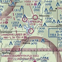
|
| Airport distance calculator |
|---|
|
|
| Sunrise and sunset |
|---|
|
Times for 26-Nov-2025
| | Local
(UTC-5) | | Zulu
(UTC) |
|---|
| Morning civil twilight | | 07:18 | | 12:18 |
| Sunrise | | 07:50 | | 12:50 |
| Sunset | | 17:07 | | 22:07 |
| Evening civil twilight | | 17:39 | | 22:39 |
|
| Current date and time |
|---|
| Zulu (UTC) | 26-Nov-2025 06:56:00 |
|---|
| Local (UTC-5) | 26-Nov-2025 01:56:00 |
|---|
|
| METAR |
|---|
KRQB
13nm NW | 260615Z AUTO 16004KT 1/2SM -RA FG VV005 07/07 A2959 RMK AO2
|
KMOP
24nm E | 260615Z AUTO 16003KT 1/2SM FG OVC003 08/08 A2962 RMK AO2 T00810081
|
|
| TAF |
|---|
KGRR
43nm S | 260520Z 2606/2706 20007KT 3SM -SHRA BR OVC006 FM260800 21010G22KT 2SM -SHRA BR OVC006 FM261000 23015G25KT P6SM VCSH BKN012 FM261300 23016G30KT 2SM -SHRASN BR OVC011 FM261500 23017G34KT 1 1/2SM -SHSN OVC009 FM262100 26021G41KT 2SM -SHSN OVC010 WS020/28055KT
|
KMKG
48nm SW | 260520Z 2606/2706 19010G18KT 4SM -SHRA BR OVC007 FM260900 24020G30KT P6SM VCSH BKN013 FM261200 23021G32KT 6SM -SHRASN BR OVC019 FM261600 25025G39KT 1 1/2SM -SHRASN OVC010 FM262000 27029G48KT 1 1/2SM -SHSN OVC013 FM270000 29031G50KT 2SM -SHSN BLSN OVC015
|
|
| NOTAMs |
|---|
NOTAMs are issued by the DoD/FAA and will open in a separate window not controlled by AirNav.
|
|

