FAA INFORMATION EFFECTIVE 09 JULY 2026
Location
| FAA Identifier: | 38C |
| Lat/Long: | 43-35-54.5000N 085-29-32.9000W
43-35.908333N 085-29.548333W
43.5984722,-85.4924722
(estimated) |
| Elevation: | 897 ft. / 273 m (estimated) |
| Variation: | 04W (1985) |
| From city: | 2 miles NW of STANWOOD, MI |
| Time zone: | UTC -4 (UTC -5 during Standard Time) |
| Zip code: | 49346 |
Airport Operations
| Airport use: | Open to the public |
| Activation date: | 10/1974 |
| Control tower: | no |
| ARTCC: | CHICAGO CENTER |
| FSS: | LANSING FLIGHT SERVICE STATION |
| NOTAMs facility: | LAN (NOTAM-D service available) |
| Attendance: | IREG |
| Wind indicator: | lighted |
| Segmented circle: | yes |
Airport Communications
| CTAF: | 122.9 |
| WX AWOS-3P at RQB (7 nm N): | 125.875 (231-796-0884) |
Airport Services
| Parking: | tiedowns |
| Airframe service: | NONE |
| Powerplant service: | NONE |
| Bottled oxygen: | NONE |
| Bulk oxygen: | NONE |
Runway Information
Runway 18/36
| Dimensions: | 3472 x 100 ft. / 1058 x 30 m |
| Surface: | turf, in good condition |
| Runway edge markings: | RWY & DTHR MKD WITH 3 FT YELLOW CONES. |
| RUNWAY 18 | | RUNWAY 36 |
| Latitude: | 43-36.193833N | | 43-35.622667N |
| Longitude: | 085-29.549500W | | 085-29.547167W |
| Elevation: | 895.0 ft. | | 897.0 ft. |
| Traffic pattern: | left | | left |
| Runway heading: | 184 magnetic, 180 true | | 004 magnetic, 360 true |
| Displaced threshold: | 486 ft. | | 384 ft. |
| Obstructions: | 78 ft. trees, 92 ft. left of centerline
CTLG OBSTN EXCEEDS A 45 DEG SLP. APCH RATIO 1:1 TO DTHR OVR +30 FT TREES, 0 FT DIST, 105 FT R. | | 10 ft. road, 110 ft. left of centerline
CTLG OBSTN EXCEEDS A 45 DEG SLP. APCH RATIO 3:1 TO DTHR OVR +33 FT TREES, 130 FT DIST, 140 FT R. |
Airport Ownership and Management from official FAA records
| Ownership: | Privately-owned |
| Owner: | WALTER L CAIN ESTATE
8731 OLD STATE RD
STANWOOD, MI 49346-9083
Phone 231-823-2481 |
| Manager: | JAMES CAIN
8731 OLD STATE RD
STANWOOD, MI 49346-9083
Phone 231-580-1073 |
Additional Remarks
| - | DEER, LRG BIRDS, & OTR WILDLIFE ON & INVOF ARPT. |
| - | RWY 36: +25 FT PLINE, 650 FT TO DTHR, 125 FT L/R. |
| - | FOR CD CTC GREAT LAKES APCH AT 269-459-3344, WHEN APCH CLSD CTC CHICAGO ARTCC AT 630-906-8921. |
| - | NO SNOW REMOVAL. |
Instrument Procedures
There are no published instrument procedures at 38C.
Some nearby airports with instrument procedures:
KRQB - Roben-Hood Airport (7 nm N)
13C - Lakeview Airport/Griffith Field (13 nm SE)
7D3 - Baldwin Municipal Airport (22 nm NW)
KFFX - Fremont Municipal Airport (24 nm SW)
6D6 - Greenville Municipal Airport (29 nm S)
|
|

Road maps at:
MapQuest
Bing
Google
| Aerial photo |
|---|
WARNING: Photo may not be current or correct
 Photo by Todd Stemen / Advantage Aerial Inc.
Taken in November 2008
Photo by Todd Stemen / Advantage Aerial Inc.
Taken in November 2008
Do you have a better or more recent aerial photo of Cain Field Airport that you would like to share? If so, please send us your photo.
|
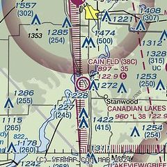
| Sectional chart |
|---|
|
| Airport distance calculator |
|---|
|
|
| Sunrise and sunset |
|---|
|
Times for 18-Jul-2026
| | Local
(UTC-4) | | Zulu
(UTC) |
|---|
| Morning civil twilight | | 05:44 | | 09:44 |
| Sunrise | | 06:18 | | 10:18 |
| Sunset | | 21:18 | | 01:18 |
| Evening civil twilight | | 21:52 | | 01:52 |
|
| Current date and time |
|---|
| Zulu (UTC) | 18-Jul-2026 20:49:53 |
|---|
| Local (UTC-4) | 18-Jul-2026 16:49:53 |
|---|
|
| METAR |
|---|
KRQB
7nm N | 182035Z AUTO 33014G18KT 2 1/2SM HZ SCT031 BKN041 OVC046 26/17 A2986 RMK AO2
|
|
| TAF |
|---|
KMKG
41nm SW | 181723Z 1818/1918 32011G18KT 5SM FU SCT060 FM190000 36010KT 6SM FU SKC
|
KGRR
43nm S | 181723Z 1818/1918 30012G20KT P6SM SCT030 BKN070 FM182200 35012KT 6SM FU SKC
|
|
| NOTAMs |
|---|
NOTAMs are issued by the DoD/FAA and will open in a separate window not controlled by AirNav.
|
|

