FAA INFORMATION EFFECTIVE 09 JULY 2026
Location
| FAA Identifier: | 7D3 |
| Lat/Long: | 43-52-31.9283N 085-50-31.4970W
43-52.532138N 085-50.524950W
43.8755356,-85.8420825
(estimated) |
| Elevation: | 828 ft. / 252 m (estimated) |
| Variation: | 06W (2020) |
| From city: | 2 miles S of BALDWIN, MI |
| Time zone: | UTC -4 (UTC -5 during Standard Time) |
| Zip code: | 49304 |
Airport Operations
| Airport use: | Open to the public |
| Activation date: | 02/1940 |
| Control tower: | no |
| ARTCC: | MINNEAPOLIS CENTER |
| FSS: | LANSING FLIGHT SERVICE STATION |
| NOTAMs facility: | LAN (NOTAM-D service available) |
| Attendance: | UNATNDD |
| Wind indicator: | yes |
| Segmented circle: | yes |
Airport Communications
| CTAF: | 122.9 |
| WX AWOS-3P at RQB (17 nm SE): | 125.875 (231-796-0884) |
- APCH/DEP SVC PRVDD BY MINNEAPOLIS ARTCC ON FREQS 120.85/322.35 (WHITE CLOUD RCAG).
Airport Services
| Parking: | tiedowns |
| Airframe service: | NONE |
| Powerplant service: | NONE |
| Bottled oxygen: | NONE |
| Bulk oxygen: | NONE |
Runway Information
Runway 9/27
| Dimensions: | 3800 x 75 ft. / 1158 x 23 m |
| Surface: | asphalt, in fair condition |
| Weight bearing capacity: | |
| RUNWAY 9 | | RUNWAY 27 |
| Latitude: | 43-52.525000N | | 43-52.482250N |
| Longitude: | 085-50.760617W | | 085-49.898067W |
| Elevation: | 818.0 ft. | | 828.0 ft. |
| Traffic pattern: | left | | left |
| Runway heading: | 100 magnetic, 094 true | | 280 magnetic, 274 true |
| Markings: | basic, in good condition | | basic, in good condition |
| Runway end identifier lights: | no | | no |
| Touchdown point: | yes, no lights | | yes, no lights |
| Obstructions: | none | | 80 ft. trees, 1382 ft. from runway, 300 ft. right of centerline, 14:1 slope to clear |
Runway 5/23
| Dimensions: | 2800 x 100 ft. / 853 x 30 m |
| Surface: | turf, in fair condition |
| Runway edge markings: | RWY & DTHR MKD WITH 3 FT YELLOW CONES. |
| RUNWAY 5 | | RUNWAY 23 |
| Latitude: | 43-52.415000N | | 43-52.726667N |
| Longitude: | 085-51.025000W | | 085-50.555833W |
| Elevation: | 816.0 ft. | | 822.0 ft. |
| Traffic pattern: | left | | left |
| Runway heading: | 053 magnetic, 047 true | | 233 magnetic, 227 true |
| Displaced threshold: | 800 ft. | | 800 ft. |
| Runway end identifier lights: | no | | no |
| Touchdown point: | yes, no lights | | yes, no lights |
| Obstructions: | 63 ft. trees, 470 ft. from runway, 140 ft. left of centerline, 7:1 slope to clear | | 15 ft. road, 267 ft. from runway, 77 ft. left of centerline, 17:1 slope to clear |
Airport Ownership and Management from official FAA records
| Ownership: | Publicly-owned |
| Owner: | VILLAGE OF BALDWIN
PO BOX 339
BALDWIN, MI 49304-0339
Phone 231-745-3587 |
| Manager: | MAC L MCCLELLAN
7668 S M-37
BALDWIN, MI 49304
Phone 231-745-7815
CELL 231-250-2551. |
Additional Remarks
| - | DEER ON & INVOF ARPT. |
| - | UAS OPS ADJ TO RWY 09/27. |
| - | GATE 5-3-2-1. |
| - | FOR CD CTC MINNEAPOLIS ARTCC AT 651-463-5588. |
| - | ARPT CLSD WHEN SNOW COVD - NO SNOW REMOVAL. |
Instrument Procedures
NOTE: All procedures below are presented as PDF files. If you need a reader for these files, you should download the free Adobe Reader.NOT FOR NAVIGATION. Please procure official charts for flight.
FAA instrument procedures published for use from 09 July 2026 at 0901Z to 06 August 2026 at 0900Z.
IAPs - Instrument Approach Procedures |
|---|
| RNAV (GPS)-A | |
download (168KB) |
| NOTE: Special Take-Off Minimums/Departure Procedures apply | |
download (122KB) |
Other nearby airports with instrument procedures:
KRQB - Roben-Hood Airport (17 nm SE)
KLDM - Mason County Airport (25 nm W)
C04 - Oceana County Airport (25 nm SW)
KFFX - Fremont Municipal Airport (27 nm S)
KMBL - Manistee County/Blacker Airport (30 nm NW)
|
|

Road maps at:
MapQuest
Bing
Google
| Aerial photo |
|---|
WARNING: Photo may not be current or correct

Do you have a better or more recent aerial photo of Baldwin Municipal Airport that you would like to share? If so, please send us your photo.
|
| Sectional chart |
|---|
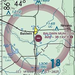
|
| Airport distance calculator |
|---|
|
|
| Sunrise and sunset |
|---|
|
Times for 02-Aug-2026
| | Local
(UTC-4) | | Zulu
(UTC) |
|---|
| Morning civil twilight | | 06:01 | | 10:01 |
| Sunrise | | 06:34 | | 10:34 |
| Sunset | | 21:05 | | 01:05 |
| Evening civil twilight | | 21:38 | | 01:38 |
|
| Current date and time |
|---|
| Zulu (UTC) | 02-Aug-2026 16:33:12 |
|---|
| Local (UTC-4) | 02-Aug-2026 12:33:12 |
|---|
|
| METAR |
|---|
KRQB
18nm SE | 021615Z AUTO 04010G14KT 010V080 10SM SCT025 BKN040 BKN046 24/18 A2986 RMK AO2
|
KLDM
25nm W | 021615Z AUTO 34009KT 10SM SCT034 BKN039 BKN045 24/20 A2987 RMK AO2
|
KFFX
27nm S | 021615Z AUTO 02010KT 10SM FEW020 BKN035 BKN043 24/18 A2986 RMK AO2
|
KMBL
29nm NW | 021556Z AUTO 31008KT 10SM OVC022 23/20 A2988 RMK AO2 SLP117 T02330200 $
|
KCAD
30nm NE | 021615Z AUTO 04011KT 10SM SCT018 BKN023 OVC065 23/18 A2989 RMK AO2
|
|
| TAF |
|---|
KMBL
29nm NW | 021533Z 0216/0312 04008KT P6SM BKN020 FM021800 04007G17KT P6SM SCT020 FM030000 VRB03KT P6SM SKC
|
|
| NOTAMs |
|---|
NOTAMs are issued by the DoD/FAA and will open in a separate window not controlled by AirNav.
|
|

