FAA INFORMATION EFFECTIVE 09 JULY 2026
Location
| FAA Identifier: | 4G1 |
| Lat/Long: | 41-26-48.3592N 080-23-28.3083W
41-26.805987N 080-23.471805W
41.4467664,-80.3911967
(estimated) |
| Elevation: | 1206.2 ft. / 367.6 m (surveyed) |
| Variation: | 09W (2015) |
| From city: | 3 miles N of GREENVILLE, PA |
| Time zone: | UTC -4 (UTC -5 during Standard Time) |
| Zip code: | 16125 |
Airport Operations
| Airport use: | Open to the public |
| Activation date: | 09/1954 |
| Control tower: | no |
| ARTCC: | CLEVELAND CENTER |
| FSS: | ALTOONA FLIGHT SERVICE STATION |
| NOTAMs facility: | AOO (NOTAM-D service available) |
| Attendance: | MON - SAT 0900-DUSK
UNATNDD THANKSGIVING, CHRISTMAS, NEW YEARS DAY & SUNDAYS. |
| Wind indicator: | lighted |
| Segmented circle: | yes |
| Lights: | ACTVT MIRL; REIL; PAPI RWY 15/33 - CTAF. |
| Beacon: | white-green (lighted land airport)
Operates sunset to sunrise. |
Airport Communications
| CTAF/UNICOM: | 122.8 |
| YOUNGSTOWN APPROACH: | 133.95 |
| YOUNGSTOWN DEPARTURE: | 133.95 |
| WX ASOS at GKJ (13 nm NE): | 126.375 (814-337-2590) |
| WX ASOS at YNG (17 nm SW): | PHONE 330-967-8953 |
- APCH/DEP SVC PRVDD BY CLEVELAND ARTCC (ZOB) ON FREQS 120.775/298.95 (CHARDON RCAG) WHEN YOUNGSTOWN APCH CTL CLSD.
Nearby radio navigation aids
| VOR radial/distance | | VOR name | | Freq | | Var |
|---|
| FKLr277/(24.0) | | FRANKLIN VOR | | 109.60 | | 06W |
| EWCr356/38.2 | | ELLWOOD CITY VOR/DME | | 115.80 | | 08W |
| NDB name | | Hdg/Dist | | Freq | | Var | | ID |
|---|
| CASTLE | | 012/25.4 | | 272 | | 09W | | UCP | ..- -.-. .--. |
Airport Services
| Fuel available: | 100LL
100LL:SELF-SVC FUEL AVBL. |
| Parking: | tiedowns |
| Airframe service: | MAJOR |
| Powerplant service: | MAJOR |
| Bottled oxygen: | NONE |
| Bulk oxygen: | NONE |
Runway Information
Runway 15/33
| Dimensions: | 3006 x 75 ft. / 916 x 23 m |
| Surface: | asphalt, in good condition
UNEVEN PAVEMENT 100 FT DOWN RWY 15 & 200 FT DOWN RWY 33. |
| Weight bearing capacity: | |
| Runway edge lights: | medium intensity |
| RUNWAY 15 | | RUNWAY 33 |
| Latitude: | 41-26.992167N | | 41-26.610333N |
| Longitude: | 080-23.681833W | | 080-23.263667W |
| Elevation: | 1163.3 ft. | | 1206.2 ft. |
| Traffic pattern: | left | | left |
| Runway heading: | 150 magnetic, 141 true | | 330 magnetic, 321 true |
| Markings: | nonprecision, in fair condition | | nonprecision, in fair condition |
| Visual slope indicator: | 2-light PAPI on left (3.00 degrees glide path) | | 2-light PAPI on left (3.00 degrees glide path) |
| Runway end identifier lights: | yes | | yes |
| Touchdown point: | yes, no lights | | yes, no lights |
| Obstructions: | none | | 37 ft. trees, 884 ft. from runway, 169 ft. right of centerline, 18:1 slope to clear |
Runway 5/23
| Dimensions: | 2551 x 118 ft. / 778 x 36 m |
| Surface: | turf, in good condition |
| Runway edge markings: | RWY 05/23 MKD WITH YELLOW CONES. |
| RUNWAY 5 | | RUNWAY 23 |
| Latitude: | 41-26.653233N | | 41-26.969900N |
| Longitude: | 080-23.654033W | | 080-23.287350W |
| Elevation: | 1196.0 ft. | | 1183.7 ft. |
| Traffic pattern: | left | | left |
| Runway heading: | 050 magnetic, 041 true | | 230 magnetic, 221 true |
| Displaced threshold: | 984 ft.
DSPLCD THLD MKD WITH YELLOW CONES. | | no |
| Markings: | NSTD, in good condition | | NSTD, in good condition |
| Touchdown point: | yes, no lights | | yes, no lights |
| Obstructions: | 64 ft. trees, 353 ft. from runway, 152 ft. right of centerline, 5:1 slope to clear | | 47 ft. trees, 135 ft. from runway, 118 ft. right of centerline, 2:1 slope to clear |
Airport Ownership and Management from official FAA records
| Ownership: | Publicly-owned |
| Owner: | BOROUGH OF GREENVILLE
MUNICIPAL BLDG
GREENVILLE, PA 16125
Phone 724-588-4193 |
| Manager: | FRED MURRIN
511 E JAMESTOWN RD
GREENVILLE, PA 16125
Phone 724-588-1665 |
Additional Remarks
| - | DEER & BIRDS ON & INVOF ARPT. |
| - | PAEW ON & INVOF ARPT. |
| - | FOR CD CTC YOUNGSTOWN APCH AT 330-856-4806, WHEN APCH CLSD CTC CLEVELAND ARTCC AT 440-774-0232. |
Instrument Procedures
NOTE: All procedures below are presented as PDF files. If you need a reader for these files, you should download the free Adobe Reader.NOT FOR NAVIGATION. Please procure official charts for flight.
FAA instrument procedures published for use from 09 July 2026 at 0901Z to 06 August 2026 at 0900Z.
IAPs - Instrument Approach Procedures |
|---|
| RNAV (GPS)-B | |
download (159KB) |
| NOTE: Special Take-Off Minimums/Departure Procedures apply | |
download (210KB) |
Other nearby airports with instrument procedures:
KGKJ - Port Meadville Airport (13 nm NE)
KYNG - Youngstown/Warren Regional Airport (17 nm SW)
29D - Grove City Airport (21 nm SE)
KHZY - Northeast Ohio Regional Airport (24 nm NW)
KFKL - Venango Regional Airport (24 nm E)
|
|

Road maps at:
MapQuest
Bing
Google
| Aerial photo |
|---|
WARNING: Photo may not be current or correct
 Photo by Bill Pixley
Photo taken 20-Sep-2017
looking west.
Photo by Bill Pixley
Photo taken 20-Sep-2017
looking west.
Do you have a better or more recent aerial photo of Greenville Municipal Airport that you would like to share? If so, please send us your photo.
|
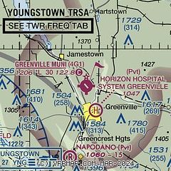
| Sectional chart |
|---|
|
| Airport distance calculator |
|---|
|
|
| Sunrise and sunset |
|---|
|
Times for 21-Jul-2026
| | Local
(UTC-4) | | Zulu
(UTC) |
|---|
| Morning civil twilight | | 05:35 | | 09:35 |
| Sunrise | | 06:07 | | 10:07 |
| Sunset | | 20:49 | | 00:49 |
| Evening civil twilight | | 21:21 | | 01:21 |
|
| Current date and time |
|---|
| Zulu (UTC) | 21-Jul-2026 04:43:30 |
|---|
| Local (UTC-4) | 21-Jul-2026 00:43:30 |
|---|
|
| METAR |
|---|
KGKJ
14nm NE | 210353Z AUTO 00000KT 10SM CLR 19/12 A2987 RMK AO2 SLP106 T01940122
|
KYNG
17nm SW | 210351Z 17004KT 10SM SCT190 19/14 A2986 RMK AO2 SLP104 T01890144 $
|
KFKL
24nm E | 210356Z AUTO 00000KT 10SM CLR 18/14 A2990 RMK AO2 SLP118 T01830139
|
KHZY
24nm NW | 210353Z AUTO 15005KT 10SM CLR 19/14 A2984 RMK AO2 SLP097 T01940139
|
KUCP
25nm S | 210356Z AUTO 00000KT 10SM CLR 17/15 A2988 RMK AO2 SLP125 T01720150 402670100
|
|
| TAF |
|---|
KYNG
17nm SW | 201737Z 2018/2118 VRB03KT 6SM HZ FEW250 FM210100 17005KT 6SM HZ BKN250 FM211200 21010G20KT P6SM BKN100 FM211500 22012G20KT 5SM -SHRA BKN050 PROB30 2115/2118 3SM -TSRA BKN025CB
|
|
| NOTAMs |
|---|
NOTAMs are issued by the DoD/FAA and will open in a separate window not controlled by AirNav.
|
|

