FAA INFORMATION EFFECTIVE 17 APRIL 2025
Location
| FAA Identifier: | 50G |
| Lat/Long: | 43-10-51.6818N 084-07-56.8038W
43-10.861363N 084-07.946730W
43.1810227,-84.1324455
(estimated) |
| Elevation: | 641 ft. / 195.4 m (surveyed) |
| Variation: | 05W (1985) |
| From city: | 1 mile W of CHESANING, MI |
| Time zone: | UTC -4 (UTC -5 during Standard Time) |
| Zip code: | 48616 |
Airport Operations
| Airport use: | Open to the public |
| Activation date: | 09/1946 |
| Control tower: | no |
| ARTCC: | CLEVELAND CENTER |
| FSS: | LANSING FLIGHT SERVICE STATION |
| NOTAMs facility: | LAN (NOTAM-D service available) |
| Attendance: | IREG |
| Wind indicator: | lighted |
| Segmented circle: | no |
| Lights: | ACTVT NSTD REIL RWY 09, 27, 18, & 36; NSTD LIRL RWY 09/27 & 18/36 - 5 CLICKS CTAF. |
Airport Communications
| CTAF: | 122.9 |
| WX AWOS-3 at RNP (11 nm S): | 118.025 (989-729-2967) |
| WX AWOS-3PT at HYX (19 nm NE): | 118.325 (989-752-3408) |
Nearby radio navigation aids
| VOR radial/distance | | VOR name | | Freq | | Var |
|---|
| MBSr190/21.2 | | SAGINAW VOR/DME | | 114.35 | | 03W |
| FNTr313/21.2 | | FLINT VORTAC | | 116.90 | | 06W |
| MOPr140/37.4 | | MOUNT PLEASANT VOR/DME | | 110.60 | | 05W |
Airport Services
Runway Information
Runway 9/27
| Dimensions: | 2800 x 150 ft. / 853 x 46 m |
| Surface: | turf, in good condition |
| Runway edge lights: | non-standard
NSTD LIRL DUE TO COLOR. |
| Runway edge markings: | RWY & DTHR MKD WITH 3 FT YELLOW CONES. |
| RUNWAY 9 | | RUNWAY 27 |
| Latitude: | 43-10.785167N | | 43-10.800833N |
| Longitude: | 084-08.374500W | | 084-07.745000W |
| Elevation: | 639.0 ft. | | 638.0 ft. |
| Traffic pattern: | left | | left |
| Runway heading: | 093 magnetic, 088 true | | 273 magnetic, 268 true |
| Displaced threshold: | no | | 800 ft. |
| Runway end identifier lights: | yes
NSTD REIL DUE TO LCTN. | | yes
NSTD REIL DUE TO LCTN. |
| Obstructions: | 34 ft. tree, 397 ft. from runway, 40 ft. right of centerline, 11:1 slope to clear | | 15 ft. road, 90 ft. right of centerline
APCH RATIO 17:1 TO DTHR OVR +59 FT TREE, 1040 FT DIST, 90 FT R. |
Runway 18/36
| Dimensions: | 2582 x 150 ft. / 787 x 46 m |
| Surface: | turf, in good condition |
| Runway edge lights: | non-standard
NSTD LIRL DUE TO COLOR. |
| Runway edge markings: | RWY & DTHR MKD WITH 3 FT YELLOW CONES. |
| RUNWAY 18 | | RUNWAY 36 |
| Latitude: | 43-11.148000N | | 43-10.723000N |
| Longitude: | 084-07.824167W | | 084-07.824167W |
| Elevation: | 634.0 ft. | | 637.0 ft. |
| Traffic pattern: | left | | left |
| Runway heading: | 185 magnetic, 180 true | | 005 magnetic, 360 true |
| Displaced threshold: | 400 ft. | | 796 ft. |
| Runway end identifier lights: | yes
NSTD REIL DUE TO LCTN. | | yes
NSTD REIL DUE TO LCTN. |
| Obstructions: | 75 ft. tree, 411 ft. from runway, 134 ft. right of centerline, 5:1 slope to clear
APCH RATIO 20:1 TO DTHR. | | 33 ft. tree, 154 ft. from runway, 132 ft. right of centerline, 4:1 slope to clear
APCH RATIO 18:1 TO DTHR OVR +63 FT TREE, 1166 FT DIST, 75 FT R. |
Airport Ownership and Management from official FAA records
| Ownership: | Publicly-owned |
| Owner: | VILLAGE OF CHESANING
204 S 4TH ST
CHESANING, MI 48616
Phone 989-845-3800
TROY FELTMAN, VILLAGE ADMINISTRATOR. |
| Manager: | RADFORD CHING
218 N FRONT ST
CHESANING, MI 48616-1098
Phone 517-974-8039 |
Additional Remarks
| - | NO WINTER SNOW REMOVAL. |
| - | FOR CD CTC GREAT LAKES APCH AT 269-459-3345, WHEN APCH CLSD CTC CLEVELAND ARTCC AT 440-774-0224/0490. |
| - | DEER & LRG BIRDS ON & INVOF ARPT. |
Instrument Procedures
There are no published instrument procedures at 50G.
Some nearby airports with instrument procedures:
KRNP - Owosso Community Airport (11 nm S)
KHYX - Saginaw County/H W Browne Airport (19 nm NE)
KMBS - MBS International Airport (21 nm N)
KFNT - Bishop International Airport (21 nm SE)
3CM - James Clements Municipal Airport (24 nm NE)
|
|

Road maps at:
MapQuest
Bing
Google
| Aerial photo |
|---|
WARNING: Photo may not be current or correct
 Photo by Ren Wall
Do you have a better or more recent aerial photo of Howard Nixon Memorial Airport that you would like to share? If so, please send us your photo.
|
| Sectional chart |
|---|
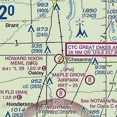
|
| Airport distance calculator |
|---|
|
|
| Sunrise and sunset |
|---|
|
Times for 29-Apr-2025
| | Local
(UTC-4) | | Zulu
(UTC) |
|---|
| Morning civil twilight | | 06:03 | | 10:03 |
| Sunrise | | 06:34 | | 10:34 |
| Sunset | | 20:34 | | 00:34 |
| Evening civil twilight | | 21:05 | | 01:05 |
|
| Current date and time |
|---|
| Zulu (UTC) | 29-Apr-2025 08:37:12 |
|---|
| Local (UTC-4) | 29-Apr-2025 04:37:12 |
|---|
|
| METAR |
|---|
KRNP
11nm S | 290815Z AUTO 20016G21KT 10SM SCT085 23/14 A2978 RMK AO2 T02300135
|
KHYX
19nm NE | 290815Z AUTO 20018G23KT 10SM CLR 22/13 A2973 RMK AO2
|
KFNT
21nm SE | 290753Z AUTO 20012KT 10SM CLR 21/12 A2981 RMK AO2 SLP091 T02110122
|
KMBS
21nm N | 290753Z AUTO 21017G27KT 10SM CLR 23/13 A2973 RMK AO2 PK WND 20030/0736 SLP063 T02280128
|
|
| TAF |
|---|
KFNT
21nm SE | 290520Z 2906/3006 20015KT P6SM SCT040 BKN150 WS020/22047KT TEMPO 2910/2914 6SM -SHRA SCT028 BKN040 FM291400 23020G35KT P6SM BKN150 PROB30 2917/2920 2SM +TSRA OVC035CB FM292100 33018G32KT P6SM FEW025
|
KMBS
21nm N | 290520Z 2906/3006 20016KT P6SM SCT040 BKN150 WS020/22048KT TEMPO 2910/2914 6SM -SHRA SCT028 BKN040 FM291400 23020G35KT P6SM BKN150 PROB30 2917/2920 2SM +TSRA OVC035CB FM292100 33018G32KT P6SM FEW025
|
|
| NOTAMs |
|---|
NOTAMs are issued by the DoD/FAA and will open in a separate window not controlled by AirNav.
|
|


