FAA INFORMATION EFFECTIVE 09 JULY 2026
Location
| FAA Identifier: | 6G1 |
| Lat/Long: | 41-36-31.7000N 079-44-28.8000W
41-36.528333N 079-44.480000W
41.6088056,-79.7413333
(estimated) |
| Elevation: | 1599.9 ft. / 487.6 m (surveyed) |
| Variation: | 10W (2015) |
| From city: | 3 miles W of TITUSVILLE, PA |
| Time zone: | UTC -4 (UTC -5 during Standard Time) |
| Zip code: | 16354 |
Airport Operations
| Airport use: | Open to the public |
| Activation date: | 11/1946 |
| Control tower: | no |
| ARTCC: | CLEVELAND CENTER |
| FSS: | ALTOONA FLIGHT SERVICE STATION |
| NOTAMs facility: | AOO (NOTAM-D service available) |
| Attendance: | UNATNDD |
| Wind indicator: | lighted |
| Segmented circle: | no |
| Lights: | ACTVT MIRL RWY 01/19 ON CTAF. |
| Beacon: | white-green (lighted land airport)
Operates sunset to sunrise. |
Airport Communications
| CTAF: | 122.9 |
| YOUNGSTOWN APPROACH: | 133.95 |
| YOUNGSTOWN DEPARTURE: | 133.95 |
| WX AWOS-3PT at FKL (15 nm S): | 118.175 ((814) 437-2066) |
- APCH/DEP SVC PRVDD BY CLEVELAND ARTCC (ZOB) ON FREQS 127.075/292.175 (WATERFORD RCAG) WHEN YOUNGSTOWN APCH CTL CLSD.
Nearby radio navigation aids
| VOR radial/distance | | VOR name | | Freq | | Var |
|---|
| FKLr033/(11.5) | | FRANKLIN VOR | | 109.60 | | 06W |
Airport Services
| Fuel available: | 100LL JET-A |
| Parking: | hangars |
| Airframe service: | MINOR |
| Powerplant service: | MINOR |
| Bottled oxygen: | NONE |
| Bulk oxygen: | NONE |
Runway Information
Runway 1/19
| Dimensions: | 4902 x 75 ft. / 1494 x 23 m |
| Surface: | asphalt, in good condition |
| Weight bearing capacity: | |
| Runway edge lights: | medium intensity |
| RUNWAY 1 | | RUNWAY 19 |
| Latitude: | 41-36.126097N | | 41-36.932053N |
| Longitude: | 079-44.452128W | | 079-44.506718W |
| Elevation: | 1533.2 ft. | | 1599.9 ft. |
| Traffic pattern: | left | | left |
| Runway heading: | 007 magnetic, 357 true | | 187 magnetic, 177 true |
| Markings: | nonprecision, in good condition | | nonprecision, in good condition |
| Touchdown point: | yes, no lights | | yes, no lights |
| Obstructions: | 66 ft. trees, 551 ft. from runway, 253 ft. left of centerline, 5:1 slope to clear
15 FT TREES; 177 FT FM THLD, 219 FT LEFT. | | 42 ft. tree, 989 ft. from runway, 282 ft. left of centerline, 18:1 slope to clear |
Airport Ownership and Management from official FAA records
| Ownership: | Publicly-owned |
| Owner: | CITY OF TITUSVILLE
107 NORTH FRANKLIN STREET
TITUSVILLE, PA 16354
Phone (814) 827-5300
EXTN 705 |
| Manager: | NEIL FRATUS
CITY OF TITUSVILLE, 107 NORTH FRANKLIN STREET
TITUSVILLE, PA 16354
Phone 814-827-5300
EXTN 705 |
Additional Remarks
| - | BIRDS & DEER ON & INVOF ARPT. |
| - | RADIO CONTROLLED ACFT INVOF ARPT. |
| - | GYRO OPNS INVOF ARPT LAST SAT EVERY MONTH. |
| - | PARALLEL TWY AND NORTH JUG HANDLE TWY MKD WITH BLUE REFLECTORS. |
| - | FOR CD CTC CLEVELAND ARTCC AT 440-774-0232. |
| - | FUEL AVBL 24/7 WITH CREDIT CARD |
| - | RWY 01 OPEN FOR TKOF & LNDG SR-SS, CLSD FOR LNDG SS-SR. |
Instrument Procedures
NOTE: All procedures below are presented as PDF files. If you need a reader for these files, you should download the free Adobe Reader.NOT FOR NAVIGATION. Please procure official charts for flight.
FAA instrument procedures published for use from 09 July 2026 at 0901Z to 06 August 2026 at 0900Z.
IAPs - Instrument Approach Procedures |
|---|
| RNAV (GPS) RWY 01 | |
download (215KB) |
| RNAV (GPS) RWY 19 | |
download (209KB) |
| NOTE: Special Take-Off Minimums/Departure Procedures apply | |
download (432KB) |
Other nearby airports with instrument procedures:
KFKL - Venango Regional Airport (15 nm S)
8G2 - Corry-Lawrence Airport (18 nm N)
KGKJ - Port Meadville Airport (21 nm W)
KAXQ - Clarion County Airport (27 nm SE)
4G1 - Greenville Municipal Airport (31 nm W)
|
|

Road maps at:
MapQuest
Bing
Google
| Aerial photo |
|---|
WARNING: Photo may not be current or correct
 Photo taken 24-Oct-2010
looking east.
Photo taken 24-Oct-2010
looking east.
Do you have a better or more recent aerial photo of Titusville Airport that you would like to share? If so, please send us your photo.
|
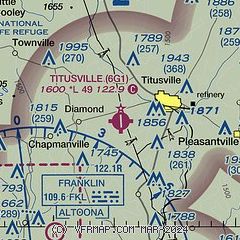
| Sectional chart |
|---|
|
| Airport distance calculator |
|---|
|
|
| Sunrise and sunset |
|---|
|
Times for 30-Jul-2026
| | Local
(UTC-4) | | Zulu
(UTC) |
|---|
| Morning civil twilight | | 05:41 | | 09:41 |
| Sunrise | | 06:12 | | 10:12 |
| Sunset | | 20:38 | | 00:38 |
| Evening civil twilight | | 21:10 | | 01:10 |
|
| Current date and time |
|---|
| Zulu (UTC) | 30-Jul-2026 16:38:06 |
|---|
| Local (UTC-4) | 30-Jul-2026 12:38:06 |
|---|
|
| METAR |
|---|
KFKL
16nm S | 301556Z AUTO 36008G14KT 10SM FEW036 24/14 A3001 RMK AO2 SLP157 T02390144
|
KGKJ
21nm W | 301553Z AUTO 34008KT 290V010 10SM SCT036 23/14 A3001 RMK AO2 SLP155 T02280144 $
|
|
| TAF |
|---|
KFKL
16nm S | 301120Z 3012/3112 34008KT P6SM SKC
|
|
| NOTAMs |
|---|
NOTAMs are issued by the DoD/FAA and will open in a separate window not controlled by AirNav.
|
|

