FAA INFORMATION EFFECTIVE 16 APRIL 2026
Location
| FAA Identifier: | BAF |
| Lat/Long: | 42-09-28.6000N 072-42-57.1000W
42-09.476667N 072-42.951667W
42.1579444,-72.7158611
(estimated) |
| Elevation: | 270 ft. / 82.3 m (surveyed) |
| Variation: | 14W (1980) |
| From city: | 3 miles N of central business district of the associated city |
| Time zone: | UTC -4 (UTC -5 during Standard Time) |
| Zip code: | 01085 |
Airport Operations
| Airport use: | Open to the public |
| Activation date: | 04/1940 |
| Control tower: | yes |
| ARTCC: | BOSTON CENTER |
| FSS: | BURLINGTON FLIGHT SERVICE STATION |
| NOTAMs facility: | BAF (NOTAM-D service available) |
| Attendance: | 0700-1900 LOCAL
FUEL AVBL 0700-1900; SVC AFT 1900 PPR - 413-485-0078. |
| Pattern altitude: | 1299 ft. MSL
TPA 1300 (1029) LGT ACFT; 1800 (1529) HVY & MIL ACFT. EXPC MIL OVHD & CLSD PAT TFC. |
| Wind indicator: | lighted |
| Segmented circle: | yes |
| Lights: | DUSK-DAWN; WHEN ATCT CLSD ACTVT MALSR RWY 20; PAPI RWY 15; HIRL RWY 02/20; MIRL RWY 15/33 - CTAF. PAPI RWY 33 OPR CONSLY. |
| Beacon: | white-green (lighted land airport)
Operates sunset to sunrise. |
| Landing fee: | yes, FEE FOR COML; CORPORATE; ACFT OVR 7500 LBS. |
| Fire and rescue: | ARFF index A |
| Airline operations: | PPR 24 HR FOR ACR OPS WITH MORE THAN 9 PAX - AMGR. |
| International operations: | customs landing rights airport |
Airport Communications
| CTAF: | 125.075 |
| ATIS: | 127.1 263.15 |
| WX ASOS: | 127.1 (413-568-2267) |
| WESTFIELD GROUND: | 121.7 289.4 [0700-2200] |
| WESTFIELD TOWER: | 125.075 251.1 [0700-2200] |
| BRADLEY APPROACH: | 125.35 |
| BRADLEY DEPARTURE: | 125.35 |
| CLEARANCE DELIVERY: | 121.7 ;WHEN TWR CLSD 121.7 |
| ANG OPS: | 309.0 |
| DEER PARK STAR: | 123.95 ;061-240 125.35 ;241-060 |
| EMERG: | 121.5 243.0 |
| NG OPS: | 123.05 356.3 46.75 |
| STELA STAR: | 125.35 |
| WX ASOS at BDL (13 nm S): | 118.15 (860-386-3480) |
Nearby radio navigation aids
| VOR radial/distance | | VOR name | | Freq | | Var |
|---|
| BAF at field | | BARNES VORTAC | | 113.00 | | 14W |
| CTRr141/13.1 | | CHESTER VOR/DME | | 115.10 | | 13W |
| HFDr359/31.9 | | HARTFORD VOR/DME | | 114.90 | | 13W |
| GDMr245/37.3 | | GARDNER VOR/DME | | 116.95 | | 14W |
Airport Services
| Fuel available: | 100LL JET-A |
| Parking: | hangars and tiedowns |
| Airframe service: | MAJOR |
| Powerplant service: | MAJOR |
| Bottled oxygen: | NONE |
| Bulk oxygen: | HIGH/LOW |
Runway Information
Runway 2/20
| Dimensions: | 9000 x 150 ft. / 2743 x 46 m
200 FT OVRN NE END & SW END. |
| Surface: | asphalt/grooved, in excellent condition |
| Weight bearing capacity: | | Single wheel: | 75.0 | | Double wheel: | 160.0 | | Double tandem: | 240.0 |
|
| Runway edge lights: | high intensity |
| RUNWAY 2 | | RUNWAY 20 |
| Latitude: | 42-08.718012N | | 42-10.176258N |
| Longitude: | 072-43.129195W | | 072-42.775928W |
| Elevation: | 260.4 ft. | | 266.5 ft. |
| Traffic pattern: | left | | left |
| Runway heading: | 024 magnetic, 010 true | | 204 magnetic, 190 true |
| Declared distances: | TORA:9000 TODA:9000 ASDA:9000 LDA:9000 | | TORA:9000 TODA:9000 ASDA:8919 LDA:8919 |
| Markings: | precision, in good condition | | precision, in good condition |
| Visual slope indicator: | 4-light PAPI on left (3.00 degrees glide path) | | 4-light PAPI on left (3.00 degrees glide path) |
| RVR equipment: | | | touchdown |
| Approach lights: | | | MALSR: 1,400 foot medium intensity approach lighting system with runway alignment indicator lights |
| Runway end identifier lights: | no | | no |
| Touchdown point: | yes, no lights | | yes, no lights |
| Instrument approach: | | | ILS |
| Obstructions: | 56 ft. trees, 1325 ft. from runway, 300 ft. right of centerline, 20:1 slope to clear | | 83 ft. trees, 2950 ft. from runway, 175 ft. right of centerline, 33:1 slope to clear |
Runway 15/33
| Dimensions: | 5000 x 75 ft. / 1524 x 23 m |
| Surface: | asphalt/grooved, in excellent condition |
| Weight bearing capacity: | | Single wheel: | 51.0 | | Double wheel: | 60.0 | | Double tandem: | 155.0 |
|
| Runway edge lights: | medium intensity |
| Operational restrictions: | RWY 15/33 NOT AVBL FOR PART 121/PART 380 OPS WITH SKED PAX CARRYING OPS MORE THAN 9 PAX SEATS AND NON-SKED PAX CARRYING OPS MORE THAN 30 PAX SEATS. |
| RUNWAY 15 | | RUNWAY 33 |
| Latitude: | 42-09.846418N | | 42-09.213998N |
| Longitude: | 072-43.305998W | | 072-42.597860W |
| Elevation: | 261.5 ft. | | 246.9 ft. |
| Traffic pattern: | left | | left |
| Runway heading: | 154 magnetic, 140 true | | 334 magnetic, 320 true |
| Displaced threshold: | 490 ft. | | no |
| Declared distances: | TORA:5000 TODA:5000 ASDA:4508 LDA:4510 | | TORA:5000 TODA:5000 ASDA:5000 LDA:5000 |
| Markings: | basic, in good condition | | basic, in good condition |
| Visual slope indicator: | 4-light PAPI on left (3.50 degrees glide path)
UNUSBL BYD 4 NM. | | 4-light PAPI on left (4.00 degrees glide path) |
| Runway end identifier lights: | yes | | no |
| Touchdown point: | yes, no lights | | yes, no lights |
| Obstructions: | 48 ft. trees, 1150 ft. from runway, 35 ft. left of centerline, 19:1 slope to clear | | 30 ft. trees, 150 ft. from runway, 1:1 slope to clear |
Airport Ownership and Management from official FAA records
| Ownership: | Publicly-owned |
| Owner: | CITY OF WESTFIELD
CITY HALL, 59 COURT ST
WESTFIELD, MA 01085
Phone 413-572-6201 |
| Manager: | DANIEL SHEARER
110 AIRPORT RD
WESTFIELD, MA 01085
Phone 413-572-6275 |
Additional Remarks
| A39-02/20 | PCR VALUE: 460/R/C/W/T |
| A39-15/33 | PCR VALUE: 600/F/A/X/T |
| E60-20 | BAK-14 BAK-12B(B) (1450 FT). |
| E60-02 | BAK-14 BAK-12B(B) (1420 FT). |
| - | JET ACFT STARTING UNITS AVBL. |
| - | CSTMS/AG/IMG - 1300-2300Z++ MON-FRI, FONE PRIOR 2300Z++ PRECEDING WKD C413-785-0365, C800-973-2867. |
| - | MISC - FIRST 400 FT RWY 02/20 CONC, MID 8200 FT ASPH. RWY 02/20 GROOVED. CLASS D ASP EFF 1200-0300Z++, OT CLASS G. LDG FEE COML, CORPORATE AND ALL ACFT OVER 5000 LB. FLT NOTIFICATION SVC, ADCUS, AVBL. LAWRS. |
| - | BE AWARE WING TIP CLRNC S RUNUP/D-ARM PAD TWY CNTRLN MKGS FOR F-15 A/C ONLY. |
| - | SERVICE-A-GEAR: REQ THRU TWR DUR TWR OPR HR, WHEN TWR CLSD REQ THRU ANG CP, WHIP ON UHF 309.0. RWY 02/20, MIL ACFT ARST BARRIERS MAY FAIL IN THE UP POSN. VERIFY STATUS OF BARRIERS PRIOR TO LDG. HVY ACFT SHOULD AVOID LDG DRCTLY ON ARST BARRIER. RWY GROOVING FOR SFC DRAINAGE WI 10 FT N & S OF BOTH ARST SYSS. |
| - | MILITARY: ANG: NO ACFT WITH WINGSPAN GREATER THAN 110 FT ALLOWED ON ANG RAMP. NSTD TXL CNTRLN MRKG LEADING INTO ANG APN. |
| - | RWY 2/20 MIL ACFT ARST BARRIERS MAY FAIL IN THE UP PSN. SML GA ACFT SHOULD USE CTN, SPCLY AT NGT, AND IF POSS CFM THE ACTUAL STS OF THE BARRIERS PRIOR TO LDG. |
| - | COLD TEMPERATURE AIRPORT. ALTITUDE CORRECTION REQUIRED AT OR BELOW -20C. |
| - | MILITARY: ANG: BASH II COND JUL & AUG FOR MIGRATORY BIRD ACT. |
| - | FOR CD WHEN ATCT CLSD, CTC BRADLEY APCH AT 860-386-3597. |
| - | SVR DOWNDRAFT AER 33 WHEN WIND NW IN EXCESS OF 15 KT. BIRDS & OTHER WILDLIFE ON & INVOF ARPT. |
| - | TWY G CLSD TO CIV OPS. |
| - | ACFT & HEL NOISE ABATEMENT PROCS IN EFCT - AMGR. |
| - | MILITARY: ANG: OPR 1200-2200Z++ TUE-FRI EXC HOL. LTD COPTER MAINT, FUEL AND ACFT PRK ARNG RAMP. NO COPTER LDG OR DEP FR PRK RAMP. CTC DSN 698-1811 OR C413-568-9151 EXTN 1811. |
| - | MILITARY: ANG: ALL TRAN ACFT MUST OBTAIN PPR NR 48 HR PRIOR; CTC C413-568-9151 EXTN 698-1228/9 OR DSN 698-1228/9. OFFL BUS 1230-2200Z++ TUE-FRI, CLSD HOL. NO DE-ICING AVBL. FOR CURRENT BIRD WATCH COND CTC HAWK OPS 309.0; DURG NON-DUTY HR CTC WHIP ON 309.0. BASH PHASE II COND, JUL, AUG AND SEP FOR MIGRATORY BIRD ACT. |
Instrument Procedures
NOTE: All procedures below are presented as PDF files. If you need a reader for these files, you should download the free Adobe Reader.NOT FOR NAVIGATION. Please procure official charts for flight.
FAA instrument procedures published for use from 16 April 2026 at 0901Z to 14 May 2026 at 0900Z.
STARs - Standard Terminal Arrivals |
|---|
| DEER PARK THREE | |
download (203KB) |
| STELA ONE (RNAV) | |
download (219KB) |
IAPs - Instrument Approach Procedures |
|---|
| HI-ILS OR LOC RWY 20 | |
download (187KB) |
| ILS OR LOC RWY 20 | |
download (323KB) |
| RNAV (GPS) RWY 02 | |
download (252KB) |
| RNAV (GPS) RWY 20 | |
download (263KB) |
| VOR RWY 20 | |
download (221KB) |
| VOR OR TACAN RWY 02 **CHANGED** | |
download (259KB) |
| HI-TACAN RWY 20 | |
download (169KB) |
| NOTE: Special Alternate Minimums apply | |
download (128KB) |
Departure Procedures |
|---|
| THUMB ONE (RNAV) | |
download (199KB) |
| NOTE: Special Take-Off Minimums/Departure Procedures apply | |
download (388KB) |
Other nearby airports with instrument procedures:
KCEF - Westover Air Reserve Base/Metropolitan Airport (8 nm E)
7B2 - Northampton Airport (11 nm NE)
KBDL - Bradley International Airport (13 nm S)
KHFD - Hartford-Brainard Airport (25 nm S)
0B5 - Turners Falls Airport (27 nm N)
|
|

Road maps at:
MapQuest
Bing
Google
| Aerial photo |
|---|
WARNING: Photo may not be current or correct
 Photo courtesy of AirNav, LLC
Photo taken 13-May-2014
looking east.
Photo courtesy of AirNav, LLC
Photo taken 13-May-2014
looking east.
Do you have a better or more recent aerial photo of Westfield-Barnes Regional Airport that you would like to share? If so, please send us your photo.
|
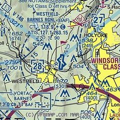
| Sectional chart |
|---|
|
 Download PDF
of official airport diagram from the FAA
| Airport distance calculator |
|---|
|
|
| Sunrise and sunset |
|---|
|
Times for 25-Apr-2026
| | Local
(UTC-4) | | Zulu
(UTC) |
|---|
| Morning civil twilight | | 05:26 | | 09:26 |
| Sunrise | | 05:56 | | 09:56 |
| Sunset | | 19:42 | | 23:42 |
| Evening civil twilight | | 20:12 | | 00:12 |
|
| Current date and time |
|---|
| Zulu (UTC) | 25-Apr-2026 13:19:02 |
|---|
| Local (UTC-4) | 25-Apr-2026 09:19:02 |
|---|
|
| METAR |
|---|
| KBAF | 251253Z 08003KT 10SM CLR 07/01 A3007 RMK AO2 SLP186 T00720011
|
KCEF
9nm E | 251155Z AUTO 00000KT 10SM CLR 06/00 A3004 RMK AO2 SLP177 T00610002 10061 21008 52017
|
KBDL
14nm S | 251251Z 14004KT 10SM SCT026 SCT100 BKN230 07/02 A3008 RMK AO2 SLP185 T00720017
|
|
| TAF |
|---|
| KBAF | 251200Z 2512/2618 VRB06KT 9999 SKC 520005 QNH3002INS BECMG 2514/2515 17006KT 9999 OVC045 620455 QNH2995INS BECMG 2522/2523 18009KT 9000 -RA BKN045 OVC060 620604 QNH2992INS BECMG 2609/2610 VRB06KT 8000 BR SCT009 BKN016 OVC060 QNH3000INS BECMG 2611/2612 VRB06KT 9000 BR SCT015 OVC065 QNH3009INS TX12/2521Z TN03/2610Z
|
KCEF
9nm E | 251200Z 2512/2618 VRB06KT 9999 FEW040 SCT170 BKN250 QNH3003INS BECMG 2516/2517 13009KT 9999 SCT050 BKN120 OVC200 QNH2999INS WND 16009KT AFT 2520 BECMG 2522/2523 19009KT 9999 VCSH SCT010 BKN020 OVC060 610605 QNH3001INS WND VRB06KT AFT 2603 TEMPO 2600/2606 8000 -RA BR SCT007 OVC012 BECMG 2610/2611 03009KT 9999 NSW FEW012 SCT035 OVC060 620603 QNH3008INS BECMG 2614/2615 06012KT 9999 SCT050 BKN090 620903 QNH3010INS TX14/2520Z TN04/2610Z
|
KBDL
14nm S | 251132Z 2512/2618 00000KT P6SM FEW250 FM251300 13005KT P6SM SCT120 OVC200 FM251800 18008KT P6SM SCT030 OVC070 FM252300 18005KT P6SM VCSH OVC030 FM260200 VRB03KT 6SM -RA BR OVC020 FM260800 03006KT 6SM -RA BR OVC020 FM261500 04006KT P6SM OVC030
|
|
| NOTAMs |
|---|
NOTAMs are issued by the DoD/FAA and will open in a separate window not controlled by AirNav.
|
|


