FAA INFORMATION EFFECTIVE 27 NOVEMBER 2025
Location
| FAA Identifier: | F01 |
| Lat/Long: | 34-16-37.5990N 099-45-34.8540W
34-16.626650N 099-45.580900W
34.2771108,-99.7596817
(estimated) |
| Elevation: | 1603.2 ft. / 488.7 m (surveyed) |
| Variation: | 08E (1985) |
| From city: | 2 miles SW of QUANAH, TX |
| Time zone: | UTC -6 (UTC -5 during Daylight Saving Time) |
| Zip code: | 79252 |
Airport Operations
| Airport use: | Open to the public |
| Activation date: | 04/1948 |
| Control tower: | no |
| ARTCC: | FORT WORTH CENTER |
| FSS: | FORT WORTH FLIGHT SERVICE STATION |
| NOTAMs facility: | FTW (NOTAM-D service available) |
| Attendance: | UNATNDD |
| Wind indicator: | lighted |
| Segmented circle: | yes |
| Lights: | MIRL RWY 18/36 PRESET LOW INTST; TO INCR INTST ACTVT - CTAF. |
| Beacon: | white-green (lighted land airport)
Operates sunset to sunrise. |
Airport Communications
Nearby radio navigation aids
| VOR radial/distance | | VOR name | | Freq | | Var |
|---|
| CDSr092/26.8 | | CHILDRESS VORTAC | | 117.00 | | 10E |
| LTSr221/33.5 | | ALTUS VORTAC | | 109.80 | | 05E |
Airport Services
| Fuel available: | 100LL
100LL:FOR FUEL OR MAINT CALL 940-839-7257. |
| Parking: | hangars and tiedowns |
| Airframe service: | NONE |
| Powerplant service: | NONE |
| Bottled oxygen: | NONE |
| Bulk oxygen: | NONE |
Runway Information
Runway 18/36
| Dimensions: | 4452 x 60 ft. / 1357 x 18 m |
| Surface: | asphalt, in good condition |
| Weight bearing capacity: | |
| Runway edge lights: | medium intensity |
| RUNWAY 18 | | RUNWAY 36 |
| Latitude: | 34-17.042333N | | 34-16.308500N |
| Longitude: | 099-45.554667W | | 099-45.573500W |
| Elevation: | 1591.1 ft. | | 1601.5 ft. |
| Traffic pattern: | left | | left |
| Runway heading: | 173 magnetic, 181 true | | 353 magnetic, 001 true |
| Markings: | nonprecision, in good condition | | nonprecision, in good condition |
| Visual slope indicator: | | | 2-light PAPI on left (3.00 degrees glide path) |
| Touchdown point: | yes, no lights | | yes, no lights |
| Obstructions: | 15 ft. road, 550 ft. from runway, 23:1 slope to clear | | none |
Runway 11/29
| Dimensions: | 2270 x 70 ft. / 692 x 21 m |
| Surface: | turf, in good condition |
| RUNWAY 11 | | RUNWAY 29 |
| Latitude: | 34-16.571317N | | 34-16.388883N |
| Longitude: | 099-45.797350W | | 099-45.403700W |
| Elevation: | 1602.0 ft. | | 1599.0 ft. |
| Traffic pattern: | left | | left |
| Runway heading: | 111 magnetic, 119 true | | 291 magnetic, 299 true |
| Displaced threshold: | no | | 360 ft.
DSPLCD THR UNMARKED. |
| Markings: | none, in fair condition | | none, in fair condition |
| Touchdown point: | yes, no lights | | yes, no lights |
| Obstructions: | none | | 15 ft. road, 135 ft. from runway, 9:1 slope to clear |
Runway 6/24
| Dimensions: | 2268 x 70 ft. / 691 x 21 m |
| Surface: | turf, in good condition |
| RUNWAY 6 | | RUNWAY 24 |
| Latitude: | 34-16.596300N | | 34-16.758767N |
| Longitude: | 099-45.797350W | | 099-45.391183W |
| Elevation: | 1602.0 ft. | | 1594.0 ft. |
| Traffic pattern: | left | | left |
| Runway heading: | 056 magnetic, 064 true | | 236 magnetic, 244 true |
| Displaced threshold: | no | | 500 ft.
DSPLCD THR UNMARKED. |
| Markings: | none, in fair condition | | none, in fair condition |
| Touchdown point: | yes, no lights | | yes, no lights |
| Obstructions: | none | | 24 ft. pole, 150 ft. from runway, 150 ft. left of centerline, 6:1 slope to clear |
Airport Ownership and Management from official FAA records
| Ownership: | Publicly-owned |
| Owner: | CITY OF QUANAH
109 KING ST, P.O. BOX 629
QUANAH, TX 79252
Phone 940-663-5336 |
| Manager: | CITY ADMINISTRATOR
109 KING ST, P.O. BOX 629
QUANAH, TX 79252
Phone 940-663-5336
CITY/AMGR. |
Additional Remarks
| - | WIDTH OF TURF RWYS BASED ON THE AREA MOWED. |
| - | FOR CD CTC FORT WORTH ARTCC AT 817-858-7584. |
Instrument Procedures
There are no published instrument procedures at F01.
Some nearby airports with instrument procedures:
F05 - Wilbarger County Airport (24 nm E)
O35 - Hollis Municipal Airport (27 nm N)
KCDS - Childress Municipal Airport (28 nm W)
3F6 - Dan E Richards Municipal Airport (30 nm SW)
KAXS - Altus/Quartz Mountain Regional Airport (33 nm NE)
|
|

Road maps at:
MapQuest
Bing
Google
| Aerial photo |
|---|
WARNING: Photo may not be current or correct
 Photo by Rick Walker
Photo taken 12-Apr-2020
looking west.
Photo by Rick Walker
Photo taken 12-Apr-2020
looking west.
Do you have a better or more recent aerial photo of Quanah Municipal Airport that you would like to share? If so, please send us your photo.
|
| Sectional chart |
|---|
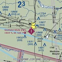
|
| Airport distance calculator |
|---|
|
|
| Sunrise and sunset |
|---|
|
Times for 06-Dec-2025
| | Local
(UTC-6) | | Zulu
(UTC) |
|---|
| Morning civil twilight | | 07:05 | | 13:05 |
| Sunrise | | 07:32 | | 13:32 |
| Sunset | | 17:28 | | 23:28 |
| Evening civil twilight | | 17:56 | | 23:56 |
|
| Current date and time |
|---|
| Zulu (UTC) | 06-Dec-2025 22:49:20 |
|---|
| Local (UTC-6) | 06-Dec-2025 16:49:20 |
|---|
|
| METAR |
|---|
KF05
24nm E | 062235Z AUTO 17009KT 10SM CLR 18/03 A2971 RMK AO2 T01760028
|
KCDS
28nm W | 062153Z AUTO 28012KT 10SM CLR 21/M02 A2967 RMK AO2 WSHFT 2059 SLP039 T02111022
|
KAXS
33nm NE | 062235Z AUTO 10013G18KT 10SM CLR 09/06 A2970 RMK AO2
|
KLTS
34nm NE | 062155Z AUTO 13009KT 10SM CLR 12/05 A2968 RMK AO2 SLP053 T01190046 $
|
KFDR
39nm E | 062153Z AUTO 13011KT 9SM CLR 10/06 A2969 RMK AO2 SLP055 T01000056 $
|
|
| TAF |
|---|
KCDS
28nm W | 062023Z 0620/0718 22012G22KT P6SM SKC FM070000 14006KT P6SM SKC FM070600 35011KT P6SM SCT250
|
KLTS
34nm NE | 060100Z 0601/0707 VRB06KT 9999 SKC QNH2991INS BECMG 0602/0603 VRB06KT 9999 FEW060 SCT100 QNH3000INS TEMPO 0603/0605 OVC040 TEMPO 0611/0614 0800 BCFG BECMG 0619/0620 18010G15KT 9999 FEW030 QNH2990INS TX11/0621Z TNM06/0613Z
|
|
| NOTAMs |
|---|
NOTAMs are issued by the DoD/FAA and will open in a separate window not controlled by AirNav.
|
|


