FAA INFORMATION EFFECTIVE 16 APRIL 2026
Location
| FAA Identifier: | FFX |
| Lat/Long: | 43-26-21.5000N 085-59-41.6000W
43-26.358333N 085-59.693333W
43.4393056,-85.9948889
(estimated) |
| Elevation: | 771.6 ft. / 235.2 m (surveyed) |
| Variation: | 04W (1995) |
| From city: | 3 miles SW of FREMONT, MI |
| Time zone: | UTC -4 (UTC -5 during Standard Time) |
| Zip code: | 49412 |
Airport Operations
| Airport use: | Open to the public |
| Activation date: | 09/1946 |
| Control tower: | no |
| ARTCC: | CHICAGO CENTER |
| FSS: | LANSING FLIGHT SERVICE STATION |
| NOTAMs facility: | FFX (NOTAM-D service available) |
| Attendance: | MON-FRI 0800-1700, ALL SAT-SUN ON CALL
FOR SVC AFT HRS CALL 616-570-2767. |
| Wind indicator: | lighted |
| Segmented circle: | yes |
| Lights: | ACTVT REIL RWY 01 & 19; PAPI RWY 19 & 28; VASI RWY 01; MIRL RWY 01/19 & 10/28 - CTAF. |
| Beacon: | white-green (lighted land airport)
Operates sunset to sunrise. |
| Landing fee: | yes |
Airport Communications
| CTAF/UNICOM: | 123.0 |
| WX AWOS-3P: | 118.775 (231-928-0715) |
| GREAT LAKES APPROACH: | 119.8 |
| GREAT LAKES DEPARTURE: | 119.8 |
| CLEARANCE DELIVERY: | 118.25 |
| WX AWOS-AV at C04 (19 nm NW): | 122.7 (231-861-7415) |
| WX ASOS at MKG (19 nm SW): | PHONE 231-246-4419 |
- APCH/DEP SVC PRVDD BY CHICAGO ARTCC ON FREQS 128.5/273.525 (PULLMAN RCAG) WHEN GREAT LAKES APCH CTL CLSD.
Airport Services
| Fuel available: | 100LL JET-A JET-A+
100LL:100LL AVBL SELF SVC.
A:JET A AVBL FULL SVC VIA TRUCK DLVY.
A+:ICING INHIBITOR AVBL UPON REQ. |
| Parking: | hangars and tiedowns |
| Airframe service: | MAJOR |
| Powerplant service: | MAJOR |
| Bottled oxygen: | NONE |
| Bulk oxygen: | NONE |
Runway Information
Runway 1/19
| Dimensions: | 6501 x 100 ft. / 1982 x 30 m |
| Surface: | asphalt/porous friction courses, in good condition |
| Weight bearing capacity: | | Single wheel: | 81.0 | | Double wheel: | 118.0 | | Dual double tandem: | 186.0 |
|
| Runway edge lights: | medium intensity |
| RUNWAY 1 | | RUNWAY 19 |
| Latitude: | 43-25.677947N | | 43-26.747913N |
| Longitude: | 085-59.789140W | | 085-59.798283W |
| Elevation: | 753.3 ft. | | 769.4 ft. |
| Traffic pattern: | left | | left |
| Runway heading: | 004 magnetic, 360 true | | 184 magnetic, 180 true |
| Markings: | nonprecision, in fair condition | | nonprecision, in fair condition |
| Visual slope indicator: | 2-box VASI on left (3.00 degrees glide path) | | 4-light PAPI on left (3.00 degrees glide path) |
| Runway end identifier lights: | yes | | yes |
| Touchdown point: | yes, no lights | | yes, no lights |
| Obstructions: | 50 ft. tree, 1850 ft. from runway, 452 ft. left of centerline, 33:1 slope to clear | | 40 ft. trees, 1285 ft. from runway, 379 ft. left of centerline, 27:1 slope to clear
ALSO 39 FT MKD PLINE, 1500 FT DIST. |
Runway 10/28
| Dimensions: | 3502 x 75 ft. / 1067 x 23 m |
| Surface: | asphalt, in good condition |
| Weight bearing capacity: | |
| Runway edge lights: | medium intensity |
| RUNWAY 10 | | RUNWAY 28 |
| Latitude: | 43-26.631765N | | 43-26.623668N |
| Longitude: | 085-59.904072W | | 085-59.113322W |
| Elevation: | 766.7 ft. | | 769.5 ft. |
| Traffic pattern: | left | | left |
| Runway heading: | 095 magnetic, 091 true | | 275 magnetic, 271 true |
| Markings: | nonprecision, in fair condition | | nonprecision, in fair condition |
| Visual slope indicator: | | | 4-light PAPI on left (3.50 degrees glide path) |
| Runway end identifier lights: | no | | no |
| Touchdown point: | yes, no lights | | yes, no lights |
Airport Ownership and Management from official FAA records
| Ownership: | Publicly-owned |
| Owner: | CITY OF FREMONT
101 E MAIN ST
FREMONT, MI 49412-1287
Phone 231-924-2101 |
| Manager: | LORI LAYNE
7756 W 60TH ST
FREMONT, MI 49412-8128
Phone 231-924-7080 |
Additional Remarks
| A39-01/19 | PCR VALUE: 320/F/C/X/T |
| - | SEAPLANE ACT ON ADJ LAKE 0.5 NM NE OF ARPT. |
| - | TRML BLDG ACES 5-3-2-1. |
| - | FOR CD WHEN GREAT LAKES APCH CLSD CTC CHICAGO ARTCC AT 630-906-8921. |
| A58-28 | 8 FT WINDSOCK, 0 FT DIST, 125 FT L. |
Instrument Procedures
NOTE: All procedures below are presented as PDF files. If you need a reader for these files, you should download the free Adobe Reader.NOT FOR NAVIGATION. Please procure official charts for flight.
FAA instrument procedures published for use from 16 April 2026 at 0901Z to 14 May 2026 at 0900Z.
IAPs - Instrument Approach Procedures |
|---|
| RNAV (GPS) RWY 01 | |
download (238KB) |
| RNAV (GPS) RWY 19 | |
download (250KB) |
| NOTE: Special Alternate Minimums apply | |
download (139KB) |
| NOTE: Special Take-Off Minimums/Departure Procedures apply | |
download (122KB) |
Other nearby airports with instrument procedures:
C04 - Oceana County Airport (19 nm NW)
KMKG - Muskegon County Airport (19 nm SW)
8D4 - Paul C Miller/Sparta Airport (23 nm SE)
3GM - Grand Haven Memorial Airpark (26 nm S)
7D3 - Baldwin Municipal Airport (27 nm N)
|
|

Road maps at:
MapQuest
Bing
Google
| Aerial photo |
|---|
WARNING: Photo may not be current or correct
 Photo courtesy of AirNav, LLC
Photo taken 28-Jul-2011
looking northeast.
Photo courtesy of AirNav, LLC
Photo taken 28-Jul-2011
looking northeast.
Do you have a better or more recent aerial photo of Fremont Municipal Airport that you would like to share? If so, please send us your photo.
|
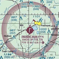
| Sectional chart |
|---|
|
| Airport distance calculator |
|---|
|
|
| Sunrise and sunset |
|---|
|
Times for 18-Apr-2026
| | Local
(UTC-4) | | Zulu
(UTC) |
|---|
| Morning civil twilight | | 06:28 | | 10:28 |
| Sunrise | | 06:58 | | 10:58 |
| Sunset | | 20:29 | | 00:29 |
| Evening civil twilight | | 20:59 | | 00:59 |
|
| Current date and time |
|---|
| Zulu (UTC) | 18-Apr-2026 15:43:30 |
|---|
| Local (UTC-4) | 18-Apr-2026 11:43:30 |
|---|
|
| METAR |
|---|
| KFFX | 181515Z AUTO 29013G16KT 10SM OVC021 07/03 A2974 RMK AO2
|
KMKG
19nm SW | 181455Z 32013G20KT 10SM BKN028 BKN230 07/02 A2977 RMK AO2 SLP080 60001 T00670017 51030
|
|
| TAF |
|---|
KMKG
19nm SW | 181135Z 1812/1912 29014G24KT 4SM -RA BR BKN009 FM181300 28016G26KT P6SM BKN015 FM181500 28016G26KT P6SM SCT025 BKN040 FM182300 27012G18KT P6SM VCSH BKN030 FM190300 24006KT P6SM SCT090
|
|
| NOTAMs |
|---|
NOTAMs are issued by the DoD/FAA and will open in a separate window not controlled by AirNav.
|
|

