FAA INFORMATION EFFECTIVE 11 JUNE 2026
Location
| FAA Identifier: | HBV |
| Lat/Long: | 27-20-58.4000N 098-44-13.0000W
27-20.973333N 098-44.216667W
27.3495556,-98.7369444
(estimated) |
| Elevation: | 662.8 ft. / 202.0 m (surveyed) |
| Variation: | 06E (2000) |
| From city: | 3 miles NW of HEBBRONVILLE, TX |
| Time zone: | UTC -5 (UTC -6 during Standard Time) |
| Zip code: | 78361 |
Airport Operations
| Airport use: | Open to the public |
| Control tower: | no |
| ARTCC: | HOUSTON CENTER |
| FSS: | SAN ANGELO FLIGHT SERVICE STATION |
| NOTAMs facility: | HBV (NOTAM-D service available) |
| Attendance: | UNATNDD
ATTENDANT ON CALL. |
| Wind indicator: | lighted |
| Segmented circle: | yes |
| Lights: | MIRL RWY 13/31 PRESET LOW INTST; TO INCR INTST ACTVT - CTAF. |
| Beacon: | white-green (lighted land airport)
Operates sunset to sunrise. |
Airport Communications
| CTAF/UNICOM: | 122.8 |
| WX AWOS-3PT: | 118.075 (361-235-4006) |
- APCH/DEP CTL SVC PRVDD BY HOUSTON ARTCC (ZHU) ON FREQS 127.8/307.2 (LAREDO RCAG).
Nearby radio navigation aids
| VOR radial/distance | | VOR name | | Freq | | Var |
|---|
| LRDr093/37.1 | | LAREDO VORTAC | | 117.40 | | 09E |
Airport Services
| Fuel available: | A
A:FOR JET A, CALL 361-850-3430. |
| Parking: | tiedowns |
| Airframe service: | NONE |
| Powerplant service: | NONE |
Runway Information
Runway 13/31
| Dimensions: | 5003 x 75 ft. / 1525 x 23 m |
| Surface: | asphalt, in good condition |
| Weight bearing capacity: | | Single wheel: | 30.0 | | Double wheel: | 72.0, GWT PAVEMENT STRENGTH PRVDD BY ARPT MGR. |
|
| Runway edge lights: | medium intensity |
| RUNWAY 13 | | RUNWAY 31 |
| Latitude: | 27-21.261573N | | 27-20.685525N |
| Longitude: | 098-44.548615W | | 098-43.886127W |
| Elevation: | 660.9 ft. | | 662.8 ft. |
| Traffic pattern: | left | | left |
| Runway heading: | 128 magnetic, 134 true | | 308 magnetic, 314 true |
| Markings: | nonprecision, in good condition | | nonprecision, in good condition |
| Visual slope indicator: | 2-light PAPI on left (3.00 degrees glide path) | | 2-light PAPI on left (3.00 degrees glide path) |
| Touchdown point: | yes, no lights | | yes, no lights |
| Obstructions: | 15 ft. trees, marked and lighted, 415 ft. from runway, 34 ft. right of centerline, 14:1 slope to clear | | 12 ft. tree, marked and lighted, 433 ft. from runway, 200 ft. right of centerline, 19:1 slope to clear |
Airport Ownership and Management from official FAA records
| Ownership: | Publicly-owned |
| Owner: | JIM HOGG COUNTY
PO BOX 729
HEBBRONVILLE, TX 78361
Phone 361-527-3015
HUMBERTO GONZALES, COUNTY JUDGE |
| Manager: | CLARK ROSSI
PO BOX 24
HEBBRONVILLE, TX 78361
Phone 956-693-7751
OR 361-527-4461 |
Additional Remarks
| - | LRG ACFT EXITING RWY 31 SHOULD BACK TAXI ON RWY DUE TO OBSTN ON TWY. |
| - | FOR CD CTC HOUSTON ARTCC AT 281-230-5622. |
| - | NO PUBLIC FACILITIES. |
Instrument Procedures
NOTE: All procedures below are presented as PDF files. If you need a reader for these files, you should download the free Adobe Reader.NOT FOR NAVIGATION. Please procure official charts for flight.
FAA instrument procedures published for use from 11 June 2026 at 0901Z to 09 July 2026 at 0900z.
IAPs - Instrument Approach Procedures |
|---|
| RNAV (GPS) RWY 13 | |
download (228KB) |
| NOTE: Special Alternate Minimums apply | |
download (16KB) |
| NOTE: Special Take-Off Minimums/Departure Procedures apply | |
download (105KB) |
Other nearby airports with instrument procedures:
KBKS - Brooks County Airport (34 nm E)
KIKG - Kleberg County Airport (39 nm E)
KLRD - Laredo International Airport (40 nm W)
KALI - Alice International Airport (44 nm NE)
KNOG - Orange Grove Naval Auxiliary Field (49 nm NE)
|
|

Road maps at:
MapQuest
Bing
Google
| Aerial photo |
|---|
WARNING: Photo may not be current or correct
 Photo by Bryan Christ
Photo taken 19-Aug-2011
looking southeast.
Photo by Bryan Christ
Photo taken 19-Aug-2011
looking southeast.
Do you have a better or more recent aerial photo of Jim Hogg County Airport that you would like to share? If so, please send us your photo.
|
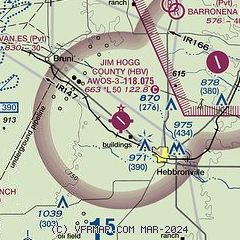
| Sectional chart |
|---|
|
| Airport distance calculator |
|---|
|
|
| Sunrise and sunset |
|---|
|
Times for 04-Jul-2026
| | Local
(UTC-5) | | Zulu
(UTC) |
|---|
| Morning civil twilight | | 06:19 | | 11:19 |
| Sunrise | | 06:46 | | 11:46 |
| Sunset | | 20:33 | | 01:33 |
| Evening civil twilight | | 20:59 | | 01:59 |
|
| Current date and time |
|---|
| Zulu (UTC) | 04-Jul-2026 21:25:45 |
|---|
| Local (UTC-5) | 04-Jul-2026 16:25:45 |
|---|
|
| METAR |
|---|
| KHBV | 042055Z AUTO 12008G16KT 090V180 10SM CLR 35/21 A2994 RMK AO2 T03510205 58017 $
|
|
| TAF |
|---|
KLRD
41nm W | 041720Z 0418/0518 14013G20KT P6SM SKC FM050600 14009KT P6SM SKC
|
MMNL
44nm W | 041727Z 0418/0518 14010KT P6SM SKC FM042000 15010G20KT 6SM HZ SCT020 BKN070 FM050000 15015KT 6SM HZ SCT020 BKN100 FM050600 15010KT 6SM HZ BKN020 TEMPO 0512/0516 3SM BR BKN010
|
KALI
45nm NE | 041720Z 0418/0518 15010G17KT P6SM SCT030 FM042200 13013G20KT P6SM SKC FM050200 14007KT P6SM SKC FM051000 VRB06KT 3SM BR SCT015 TEMPO 0510/0514 1/2SM FG BKN015 FM051500 17010KT P6SM SCT025
|
KNQI
50nm E | 041500Z 0415/0515 14010KT 9999 SCT050 QNH2988INS BECMG 0418/0420 14014G24KT 9999 SCT050 QNH2986INS BECMG 0503/0505 16010KT 9999 SCT050 QNH2985INS BECMG 0510/0512 VRB06KT 6000 BR SCT003 BKN020 QNH2985INS AUTOMATED SENSOR METWATCH 0415 TIL 0607 TX36/0420Z TN25/0510Z RTD 1502 FN00321
|
|
| NOTAMs |
|---|
NOTAMs are issued by the DoD/FAA and will open in a separate window not controlled by AirNav.
|
|

