FAA INFORMATION EFFECTIVE 27 NOVEMBER 2025
Location
| FAA Identifier: | I17 |
| Lat/Long: | 40-09-52.9000N 084-18-30.3000W
40-09.881667N 084-18.505000W
40.1646944,-84.3084167
(estimated) |
| Elevation: | 993.1 ft. / 302.7 m (surveyed) |
| Variation: | 06W (2005) |
| From city: | 3 miles NW of PIQUA, OH |
| Time zone: | UTC -5 (UTC -4 during Daylight Saving Time) |
| Zip code: | 45356 |
Airport Operations
| Airport use: | Open to the public |
| Activation date: | 04/1945 |
| Control tower: | no |
| ARTCC: | INDIANAPOLIS CENTER |
| FSS: | DAYTON FLIGHT SERVICE STATION |
| NOTAMs facility: | DAY (NOTAM-D service available) |
| Attendance: | MON-FRI 0800-1700
UNATNDD MAJOR HOLS. |
| Wind indicator: | lighted |
| Segmented circle: | no |
| Lights: | ACTVT REIL RWY 08 & 26; MIRL RWY 08/26 - CTAF. PAPI RWY 08 & 26 OPR CONSLY. |
| Beacon: | white-green (lighted land airport)
Operates sunset to sunrise. |
Airport Communications
| CTAF/UNICOM: | 123.0 |
| COLUMBUS APPROACH: | 134.45 |
| COLUMBUS DEPARTURE: | 134.45 |
| WX AWOS-3 at SCA (9 nm NE): | 120.425 (937-492-3683) |
| WX AWOS-3PT at VES (11 nm W): | 125.9 (937-526-3154) |
| WX ASOS at DAY (16 nm S): | PHONE 937-419-1421 |
| WX AWOS-3PT at AXV (20 nm N): | 128.325 (419-753-2821) |
Nearby radio navigation aids
| VOR radial/distance | | VOR name | | Freq | | Var |
|---|
| DQNr026/9.8 | | DAYTON VOR/DME | | 114.50 | | 01W |
| RODr244/14.2 | | ROSEWOOD VORTAC | | 117.50 | | 05W |
Airport Services
| Fuel available: | 100LL JET-A+ JET-A1+
100LL:FUEL AVBL H24 VIA CREDIT CARD. |
| Parking: | hangars and tiedowns |
| Airframe service: | MINOR
PROP RPRS. |
| Powerplant service: | MINOR |
| Bottled oxygen: | NONE |
| Bulk oxygen: | NONE |
Runway Information
Runway 8/26
| Dimensions: | 3998 x 75 ft. / 1219 x 23 m |
| Surface: | asphalt, in fair condition |
| Weight bearing capacity: | | Single wheel: | 30.0 | | Double wheel: | 36.0 |
|
| Runway edge lights: | medium intensity |
| RUNWAY 8 | | RUNWAY 26 |
| Latitude: | 40-09.798985N | | 40-09.963593N |
| Longitude: | 084-18.921203W | | 084-18.090302W |
| Elevation: | 993.1 ft. | | 984.7 ft. |
| Traffic pattern: | left | | left |
| Runway heading: | 082 magnetic, 076 true | | 262 magnetic, 256 true |
| Markings: | nonprecision, in fair condition | | nonprecision, in fair condition |
| Visual slope indicator: | 2-light PAPI on left (3.00 degrees glide path)
PAPI UNUSBL BYD 6 DEGS RIGHT OF CNTRLN. | | 2-light PAPI on left (3.00 degrees glide path) |
| Runway end identifier lights: | yes | | yes |
| Touchdown point: | yes, no lights | | yes, no lights |
| Obstructions: | 8 ft. crops, 201 ft. from runway, 200 ft. left and right of centerline
+8 FT CROPS, 0-200 FT DIST, 210 FT L & 200 FT R. | | 3 ft. crops, 201 ft. from runway, 135 ft. left of centerline
+3 FT CROPS, 0-200 FT DIST, 135 FT L. |
Airport Ownership and Management from official FAA records
| Ownership: | Publicly-owned |
| Owner: | CITY OF PIQUA
CITY BUILDING, 201 W WATER ST
PIQUA, OH 45356-2235
Phone 937-778-2051 |
| Manager: | BRADYN RANSDELL
1 PROPELLER PL
PIQUA, OH 45356-2655
Phone 937-778-5742 |
Additional Remarks
| A30A-26 | CALM WIND RWY. |
| - | AEROBATIC BOX LCTD WI 1 NMR OF ARPT, BLW 4500 FT MSL, SR-SS. |
| - | ARPT CONDS UNMON MON-FRI 1600-0800, SAT-SUN, & HOLS. |
| - | FOR CD CTC COLUMBUS APCH AT 614-338-8537. |
Instrument Procedures
NOTE: All procedures below are presented as PDF files. If you need a reader for these files, you should download the free Adobe Reader.NOT FOR NAVIGATION. Please procure official charts for flight.
FAA instrument procedures published for use from 27 November 2025 at 0901Z to 25 December 2025 at 0900Z.
IAPs - Instrument Approach Procedures |
|---|
| RNAV (GPS) RWY 08 | |
download (202KB) |
| RNAV (GPS) RWY 26 | |
download (185KB) |
| VOR RWY 26 | |
download (200KB) |
| VOR-A | |
download (189KB) |
| NOTE: Special Take-Off Minimums/Departure Procedures apply | |
download (460KB) |
Other nearby airports with instrument procedures:
KSCA - Sidney Municipal Airport (9 nm NE)
KVES - Darke County Airport (11 nm W)
3I7 - Dayton/Phillipsburg Airport (16 nm S)
KDAY - James M Cox Dayton International Airport (16 nm S)
KAXV - Neil Armstrong Airport (20 nm N)
|
|

Road maps at:
MapQuest
Bing
Google
| Aerial photo |
|---|
WARNING: Photo may not be current or correct

Do you have a better or more recent aerial photo of Piqua Airport/Hartzell Field that you would like to share? If so, please send us your photo.
|
| Sectional chart |
|---|
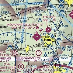
|
| Airport distance calculator |
|---|
|
|
| Sunrise and sunset |
|---|
|
Times for 12-Dec-2025
| | Local
(UTC-5) | | Zulu
(UTC) |
|---|
| Morning civil twilight | | 07:21 | | 12:21 |
| Sunrise | | 07:51 | | 12:51 |
| Sunset | | 17:11 | | 22:11 |
| Evening civil twilight | | 17:41 | | 22:41 |
|
| Current date and time |
|---|
| Zulu (UTC) | 12-Dec-2025 20:07:22 |
|---|
| Local (UTC-5) | 12-Dec-2025 15:07:22 |
|---|
|
| METAR |
|---|
KVES
11nm W | 121955Z AUTO 23005KT 10SM BKN023 BKN028 BKN033 M00/M03 A3007 RMK AO2
|
KDAY
16nm S | 121956Z VRB03KT 10SM OVC021 00/M05 A3008 RMK AO2 SLP196 T00001050
|
KAXV
20nm N | 121955Z AUTO 00000KT 10SM OVC025 00/M05 A3008 RMK AO2
|
|
| TAF |
|---|
KDAY
16nm S | 121731Z 1218/1318 14004KT P6SM SCT015 BKN050 FM122000 16003KT P6SM BKN015 OVC040 FM130200 24007KT P6SM OVC015 FM131000 27012KT P6SM OVC012 FM131600 28012KT 3SM -SN OVC012
|
|
| NOTAMs |
|---|
NOTAMs are issued by the DoD/FAA and will open in a separate window not controlled by AirNav.
|
|


