FAA INFORMATION EFFECTIVE 16 APRIL 2026
Location
| FAA Identifier: | ICL |
| Lat/Long: | 40-43-19.9000N 095-01-35.8000W
40-43.331667N 095-01.596667W
40.7221944,-95.0266111
(estimated) |
| Elevation: | 995.9 ft. / 303.6 m (surveyed) |
| Variation: | 04E (1995) |
| From city: | 1 mile SE of CLARINDA, IA |
| Time zone: | UTC -5 (UTC -6 during Standard Time) |
| Zip code: | 51632 |
Airport Operations
| Airport use: | Open to the public |
| Activation date: | 01/1950 |
| Control tower: | no |
| ARTCC: | MINNEAPOLIS CENTER |
| FSS: | FORT DODGE FLIGHT SERVICE STATION |
| NOTAMs facility: | ICL (NOTAM-D service available) |
| Attendance: | 0800-1700 |
| Wind indicator: | lighted |
| Segmented circle: | yes |
| Lights: | ACTVT MIRL RY 02/20; REIL RY 20 AND PAPI RY 02 & 20 - CTAF. |
| Beacon: | white-green (lighted land airport)
Operates sunset to sunrise. |
Airport Communications
| CTAF/UNICOM: | 122.8 |
| WX AWOS-3: | 132.025 (712-542-3345) |
| WX AWOS-3 at SDA (18 nm W): | 125.525 (712-246-4021) |
- APCH/DEP SVC PRVDD BY MINNEAPOLIS ARTCC ON FREQS 119.6/290.4 (OMAHA RCAG).
Airport Services
| Fuel available: | 100LL JET-A |
| Parking: | tiedowns |
| Airframe service: | MINOR |
| Powerplant service: | MINOR |
| Bottled oxygen: | NONE |
| Bulk oxygen: | NONE |
Runway Information
Runway 2/20
| Dimensions: | 5002 x 75 ft. / 1525 x 23 m |
| Surface: | concrete, in good condition |
| Weight bearing capacity: | | PCN 7 /R/B/W/T | | Single wheel: | 12.0 |
|
| Runway edge lights: | medium intensity |
| RUNWAY 2 | | RUNWAY 20 |
| Latitude: | 40-42.910528N | | 40-43.660705N |
| Longitude: | 095-01.835335W | | 095-01.388707W |
| Elevation: | 990.7 ft. | | 995.0 ft. |
| Traffic pattern: | left | | left |
| Runway heading: | 020 magnetic, 024 true | | 200 magnetic, 204 true |
| Markings: | nonprecision, in good condition | | nonprecision, in good condition |
| Visual slope indicator: | 2-light PAPI on left (3.00 degrees glide path) | | 2-light PAPI on left (3.00 degrees glide path) |
| Runway end identifier lights: | no | | yes |
| Touchdown point: | yes, no lights | | yes, no lights |
| Obstructions: | 13 ft. road, 475 ft. from runway, 280 ft. right of centerline, 21:1 slope to clear | | 99 ft. bldg, 2570 ft. from runway, 155 ft. left of centerline, 23:1 slope to clear |
Runway 13/31
| Dimensions: | 2729 x 280 ft. / 832 x 85 m |
| Surface: | turf, in fair condition |
| Runway edge markings: | MKD WITH YELLOW CONES. |
| RUNWAY 13 | | RUNWAY 31 |
| Latitude: | 40-43.589480N | | 40-43.238283N |
| Longitude: | 095-01.752160W | | 095-01.383673W |
| Elevation: | 995.8 ft. | | 982.5 ft. |
| Traffic pattern: | left | | left |
| Runway heading: | 137 magnetic, 141 true | | 317 magnetic, 321 true |
| Touchdown point: | yes, no lights | | yes, no lights |
Airport Ownership and Management from official FAA records
| Ownership: | Publicly-owned |
| Owner: | CITY OF CLARINDA
P.O. BOX 339
CLARINDA, IA 51632
Phone 712-542-2136
GARY MC CLARNON, CITY MGR, 712-542-2136. |
| Manager: | MILO BEERY
3042 - 210TH STREET
CLARINDA, IA 51632
Phone 712-542-3010 |
Additional Remarks
| - | FOR CD CTC MINNEAPOLIS ARTCC AT 651-463-5588. |
| - | RWY 13/31 - NO SNOW REMOVAL, RWY CLSD WHEN SNOW CONDITIONS EXIST. |
Instrument Procedures
NOTE: All procedures below are presented as PDF files. If you need a reader for these files, you should download the free Adobe Reader.NOT FOR NAVIGATION. Please procure official charts for flight.
FAA instrument procedures published for use from 16 April 2026 at 0901Z to 14 May 2026 at 0900Z.
IAPs - Instrument Approach Procedures |
|---|
| RNAV (GPS) RWY 02 | |
download (227KB) |
| RNAV (GPS) RWY 20 | |
download (212KB) |
| NOTE: Special Alternate Minimums apply | |
download (124KB) |
| NOTE: Special Take-Off Minimums/Departure Procedures apply | |
download (428KB) |
Other nearby airports with instrument procedures:
KSDA - Shenandoah Municipal Airport (18 nm W)
KRDK - Red Oak Municipal Airport (20 nm NW)
KCRZ - Corning Municipal Airport (20 nm NE)
KEVU - Northwest Missouri Regional Airport (23 nm S)
K57 - Gould Peterson Municipal Airport (23 nm SW)
|
|

Road maps at:
MapQuest
Bing
Google
| Aerial photo |
|---|
WARNING: Photo may not be current or correct
 Photo courtesy of AirNav, LLC
Photo taken 09-Nov-2013
looking north.
Photo courtesy of AirNav, LLC
Photo taken 09-Nov-2013
looking north.
Do you have a better or more recent aerial photo of Schenck Field Airport that you would like to share? If so, please send us your photo.
|
| Sectional chart |
|---|
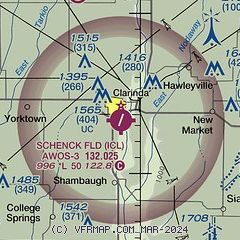
|
| Airport distance calculator |
|---|
|
|
| Sunrise and sunset |
|---|
|
Times for 06-May-2026
| | Local
(UTC-5) | | Zulu
(UTC) |
|---|
| Morning civil twilight | | 05:43 | | 10:43 |
| Sunrise | | 06:13 | | 11:13 |
| Sunset | | 20:20 | | 01:20 |
| Evening civil twilight | | 20:50 | | 01:50 |
|
| Current date and time |
|---|
| Zulu (UTC) | 07-May-2026 02:01:06 |
|---|
| Local (UTC-5) | 06-May-2026 21:01:06 |
|---|
|
| METAR |
|---|
| KICL | 070155Z AUTO 00000KT 10SM CLR 10/00 A3002 RMK AO2
|
KSDA
18nm W | 070155Z AUTO 00000KT 10SM CLR 13/M05 A2999 RMK AO2
|
|
| TAF |
|---|
KOFF
47nm NW | 061800Z 0618/0724 30015G20KT 9999 BKN080 BKN200 QNH2999INS WND 29010G15KT AFT 0700 TEMPO 0618/0620 32015G25KT BECMG 0701/0702 18006KT 9999 FEW120 QNH2994INS BECMG 0707/0708 22009KT 9999 SKC WS015/25040KT QNH2987INS BECMG 0713/0714 24010G15KT 9999 SKC 510204 QNH2982INS BECMG 0719/0720 31010G15KT 9999 FEW070 510204 QNH2978INS TX22/0718Z TN04/0710Z
|
|
| NOTAMs |
|---|
NOTAMs are issued by the DoD/FAA and will open in a separate window not controlled by AirNav.
|
|

