FAA INFORMATION EFFECTIVE 22 JANUARY 2026
Location
| FAA Identifier: | AJO |
| Lat/Long: | 33-53-51.5547N 117-36-08.7831W
33-53.859245N 117-36.146385W
33.8976541,-117.6024398
(estimated) |
| Elevation: | 533 ft. / 162.5 m (surveyed) |
| Variation: | 14E (1980) |
| From city: | 3 miles NW of CORONA, CA |
| Time zone: | UTC -8 (UTC -7 during Daylight Saving Time) |
| Zip code: | 92880 |
Airport Operations
| Airport use: | Open to the public |
| Activation date: | 04/1960 |
| Control tower: | no |
| ARTCC: | LOS ANGELES CENTER |
| FSS: | RIVERSIDE FLIGHT SERVICE STATION |
| NOTAMs facility: | AJO (NOTAM-D service available) |
| Attendance: | MON-FRI 0700-1700 |
| Pattern altitude: | NO TURNS ONTO XW LEG TIL ACFT IS WI 300 FT OF RECOMMENDED TPA. |
| Wind indicator: | lighted |
| Segmented circle: | yes |
| Lights: | ACTVT MIRL RY 07/25 VASI & REIL RY 25 - CTAF. |
| Beacon: | white-green (lighted land airport)
Operates sunset to sunrise. |
Airport Communications
| CTAF/UNICOM: | 122.7 |
| WX AWOS-3PT: | 132.175 (951-340-4764) |
| SOCAL APPROACH: | 135.4 135.4 |
| SOCAL DEPARTURE: | 135.4 135.4 |
| CLASS C: | 127.0 ;NORTH-NE 135.4 ;SOUTH-SW |
| IC: | 135.4 |
| SETER STAR: | 127.0 |
| ZIGGY STAR: | 127.0 |
| WX ASOS at CNO (5 nm N): | PHONE 909-393-5823 |
| WX ASOS at RAL (8 nm NE): | 128.8 (951-352-4392) |
| WX ASOS at ONT (10 nm N): | PHONE 909-937-2186 |
| WX AWOS-3P at CCB (14 nm N): | 119.525 (909-985-4731) |
| WX AWOS-3PT at POC (15 nm NW): | PHONE 909-962-5407 |
| WX ASOS at SNA (19 nm SW): | PHONE 714-338-2330 |
| WX ASOS at FUL (19 nm W): | PHONE 714-870-1372 |
Nearby radio navigation aids
| VOR radial/distance | | VOR name | | Freq | | Var |
|---|
| PDZr236/3.8 | | PARADISE VORTAC | | 112.20 | | 15E |
| RALr232/(8.3) | | RIVERSIDE VOR | | 108.60 | | 14E |
| POMr125/14.2 | | POMONA VORTAC | | 110.40 | | 15E |
| ELBr012/14.8 | | EL TORO VOR/DME | | 117.20 | | 14E |
| HDFr275/(22.0) | | HOMELAND VOR | | 112.05 | | 14E |
| SLIr058/23.6 | | SEAL BEACH VORTAC | | 115.70 | | 15E |
Airport Services
| Fuel available: | 100LL |
| Parking: | tiedowns |
| Airframe service: | MAJOR |
| Powerplant service: | MAJOR |
| Bottled oxygen: | NONE |
| Bulk oxygen: | NONE |
Runway Information
Runway 7/25
| Dimensions: | 3200 x 60 ft. / 975 x 18 m |
| Surface: | asphalt, in fair condition |
| Weight bearing capacity: | |
| Runway edge lights: | medium intensity |
| RUNWAY 7 | | RUNWAY 25 |
| Latitude: | 33-53.855827N | | 33-53.863912N |
| Longitude: | 117-36.462810W | | 117-35.830277W |
| Elevation: | 515.0 ft. | | 533.0 ft. |
| Traffic pattern: | right | | left |
| Runway heading: | 075 magnetic, 089 true | | 255 magnetic, 269 true |
| Displaced threshold: | 194 ft. | | 196 ft. |
| Markings: | basic, in good condition | | basic, in good condition |
| Visual slope indicator: | | | 4-box VASI on left (4.00 degrees glide path) |
| Runway end identifier lights: | | | yes |
| Touchdown point: | yes, no lights | | yes, no lights |
| Obstructions: | 40 ft. trees, 400 ft. from runway, 265 ft. both sides of centerline, 5:1 slope to clear
RWY 07 APCH RATIO TO DSPLCD THR 20:1 | | 6 ft. fence, lighted, 200 ft. from runway
RWY 25 APCH RATIO TO DSPLCD THR 34:1. |
Airport Ownership and Management from official FAA records
| Ownership: | Publicly-owned |
| Owner: | CITY OF CORONA
400 SOUTH VICENTIA AVE
CORONA, CA 92882
Phone 951-736-2289
ON LEASE TO CITY OF CORONA FROM ARMY CORPS OF ENGINEERS. |
| Manager: | MOSES CORTEZ
400 SOUTH VICENTIA AVE, SUITE 225
CORONA, CA 92882
Phone 951-739-4957
AIRPORT ADDRESS: 1900 AVIATION DRIVE, CORONA, CA 92880. |
Additional Remarks
| - | NOISE ABATEMENT PROCEDURES: RY 25 STRAIGHT-IN APCH NOT RECOMMENDED. AVOID FLYING OVER HOUSES ON BLUFF AT EAST END. FLY OVER WASH/CREEK. RY 07 REQUIRES A 15 DEG RIGHT TURN AT DEP END TO FOLLOW WASH/CREEK. |
| - | UNLGTD TWR 828 FT MSL 3 MILES E OF ARPT. |
| - | NO INTERSECTION TAKEOFFS. |
| - | NO TOUCH AND GO OPERATIONS ON WKNDS AND HOLS. |
| - | NO HELICOPTER TRNG AFTER 2000 |
| - | FOR CD CTC SOCAL APCH AT 800-448-3724. |
Instrument Procedures
NOTE: All procedures below are presented as PDF files. If you need a reader for these files, you should download the free Adobe Reader.NOT FOR NAVIGATION. Please procure official charts for flight.
FAA instrument procedures published for use from 22 January 2026 at 0901Z to 19 February 2026 at 0900z.
STARs - Standard Terminal Arrivals |
|---|
| SETER FIVE | |
download (243KB) |
| ZIGGY EIGHT | |
2 pages:
[1] [2] (401KB) |
IAPs - Instrument Approach Procedures |
|---|
| RNAV (GPS)-B | |
download (180KB) |
| VOR-A | |
download (205KB) |
| NOTE: Special Alternate Minimums apply | |
download (141KB) |
| NOTE: Special Take-Off Minimums/Departure Procedures apply | |
download (355KB) |
Other nearby airports with instrument procedures:
KCNO - Chino Airport (5 nm N)
KRAL - Riverside Airport (8 nm NE)
KONT - Ontario International Airport (10 nm N)
KRIR - Flabob Airport (11 nm NE)
KCCB - Cable Airport (14 nm N)
KPOC - Brackett Field Airport (15 nm NW)
KRIV - March Air Reserve Base (17 nm E)
KSNA - John Wayne/Orange County Airport (19 nm SW)
KFUL - Fullerton Municipal Airport (19 nm W)
|
|

Road maps at:
MapQuest
Bing
Google
| Aerial photo |
|---|
WARNING: Photo may not be current or correct
 Photo by Fred Emmert AirViews.com
Photo taken 09-Feb-2015
looking southeast.
Photo by Fred Emmert AirViews.com
Photo taken 09-Feb-2015
looking southeast.
Do you have a better or more recent aerial photo of Corona Municipal Airport that you would like to share? If so, please send us your photo.
|
| Sectional chart |
|---|
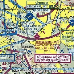
|
CAUTION: Diagram may not be current

| Airport distance calculator |
|---|
|
|
| Sunrise and sunset |
|---|
|
Times for 07-Feb-2026
| | Local
(UTC-8) | | Zulu
(UTC) |
|---|
| Morning civil twilight | | 06:18 | | 14:18 |
| Sunrise | | 06:44 | | 14:44 |
| Sunset | | 17:26 | | 01:26 |
| Evening civil twilight | | 17:52 | | 01:52 |
|
| Current date and time |
|---|
| Zulu (UTC) | 08-Feb-2026 05:38:23 |
|---|
| Local (UTC-8) | 07-Feb-2026 21:38:23 |
|---|
|
| METAR |
|---|
| KAJO | 080456Z AUTO 13006KT 10SM CLR 17/03 A3017 RMK AO2 SLP214 T01720033
|
KCNO
5nm N | 080453Z AUTO 13003KT 10SM CLR 16/11 A3018 RMK AO2 SLP216 LAST T01610106 $
|
KRAL
8nm NE | 080453Z AUTO 07004KT 10SM CLR 17/05 A3017 RMK AO2 SLP206 T01720050 $
|
KONT
9nm N | 080453Z 31006KT 10SM FEW250 18/09 A3017 RMK AO2 SLP212 T01780089 $
|
KCCB
14nm N | 119.525 909-985-4731
080515Z AUTO 00000KT 10SM CLR 18/M02 A3018 RMK AO2
|
KPOC
15nm NW | 080447Z 00000KT 10SM CLR 17/08 A3017 RMK LAST
|
KRIV
17nm E | 080455Z AUTO 00000KT 10SM CLR 17/00 A3016 RMK AO2 SLP208 T01710003
|
KFUL
19nm W | 080453Z AUTO 00000KT 10SM CLR 17/12 A3013 RMK AO2 SLP203 T01670122
|
KSNA
19nm SW | 080453Z 00000KT 10SM FEW020 17/13 A3014 RMK AO2 SLP206 T01720133
|
|
| TAF |
|---|
KONT
9nm N | 071722Z 0718/0824 VRB03KT 6SM HZ SKC FM072100 29008KT P6SM SKC FM080400 VRB04KT P6SM SKC FM081700 03007KT P6SM SKC FM082300 26007KT P6SM SKC
|
KRIV
17nm E | 080400Z 0804/0910 29006KT 9999 FEW250 QNH3015INS BECMG 0806/0807 VRB04KT 9999 FEW250 QNH3014INS TEMPO 0823/0904 32012KT BECMG 0904/0905 32004KT 9999 SKC QNH3014INS BECMG 0909/0910 08004KT 9999 SKC QNH3009INS TX27/0822Z TN04/0814Z
|
KSNA
19nm SW | 071722Z 0718/0818 VRB04KT P6SM FEW022 FM071900 26009KT P6SM SKC FM080200 VRB04KT P6SM SKC
|
|
| NOTAMs |
|---|
NOTAMs are issued by the DoD/FAA and will open in a separate window not controlled by AirNav.
|
|


