FAA INFORMATION EFFECTIVE 09 JULY 2026
Location
| FAA Identifier: | ONT |
| Lat/Long: | 34-03-21.6510N 117-36-04.2750W
34-03.360850N 117-36.071250W
34.0560142,-117.6011875
(estimated) |
| Elevation: | 944.1 ft. / 287.8 m (surveyed) |
| Variation: | 12E (2020) |
| From city: | 2 miles E of ONTARIO, CA |
| Time zone: | UTC -7 (UTC -8 during Standard Time) |
| Zip code: | 91761 |
Airport Operations
| Airport use: | Open to the public |
| Activation date: | 04/1940 |
| Control tower: | yes |
| ARTCC: | LOS ANGELES CENTER |
| FSS: | RIVERSIDE FLIGHT SERVICE STATION |
| NOTAMs facility: | ONT (NOTAM-D service available) |
| Attendance: | CONTINUOUS |
| Wind indicator: | lighted |
| Segmented circle: | no |
| Beacon: | white-green (lighted land airport)
Operates sunset to sunrise. |
| Fire and rescue: | ARFF index D |
| International operations: | US CUSTOMS USER FEE ARPT. |
Airport Communications
| WX ASOS: | PHONE 909-472-0788 |
| ONTARIO GROUND: | 121.9 257.8 |
| ONTARIO TOWER: | 120.6 360.775 |
| SOCAL APPROACH: | 127.0 ;NORTH-NE 134.0 ;NORTHEAST-SOUTH 135.4 ;SOUTH-SW |
| SOCAL DEPARTURE: | 127.0 ;NORTH-NE 134.0 ;NORTHEAST-SOUTH 135.4 ;SOUTH-SW |
| CLEARANCE DELIVERY: | 132.9 |
| CLASS C: | 125.5 ;SW-NORTH 127.0 ;NORTH-NE 134.0 ;NORTHEAST-SOUTH |
| D-ATIS: | 124.25 |
| EMERG: | 121.5 243.0 |
| KARLB STAR: | 127.4 |
| POMONA DP: | 125.5 |
| RAJEE DP: | 135.4 |
| SCBBY STAR: | 126.7 ;EAST 134.0 ;SOUTHEAST |
| SETER STAR: | 127.0 |
| SNSHN DP: | 125.5 |
| ZIGGY STAR: | 127.0 |
| WX ASOS at CNO (5 nm S): | PHONE 909-393-5823 |
| WX AWOS-3P at CCB (5 nm NW): | 119.525 (909-985-4731) |
| WX AWOS-3PT at POC (9 nm W): | PHONE 909-962-5407 |
| WX AWOS-3PT at AJO (10 nm S): | 132.175 (951-340-4764) |
| WX ASOS at RAL (10 nm SE): | 128.8 (951-352-4392) |
| WX AWOS-3 at SBD (18 nm E): | PHONE 909-382-0067 |
Nearby radio navigation aids
| VOR radial/distance | | VOR name | | Freq | | Var |
|---|
| PDZr322/9.0 | | PARADISE VORTAC | | 112.20 | | 15E |
| POMr083/9.3 | | POMONA VORTAC | | 110.40 | | 15E |
| RALr295/(9.7) | | RIVERSIDE VOR | | 108.60 | | 14E |
| ELBr002/23.7 | | EL TORO VOR/DME | | 117.20 | | 14E |
| HDFr295/(26.7) | | HOMELAND VOR | | 112.05 | | 14E |
| SLIr039/27.9 | | SEAL BEACH VORTAC | | 115.70 | | 15E |
| VCVr184/(33.9) | | VICTORVILLE VOR | | 109.05 | | 14E |
| NDB name | | Hdg/Dist | | Freq | | Var | | ID |
|---|
| PETIS | | 256/11.7 | | 397 | | 14E | | SB | ... -... |
Airport Services
| Fuel available: | 100LL JET-A |
| Airframe service: | MAJOR |
| Powerplant service: | MAJOR |
| Bottled oxygen: | HIGH/LOW |
| Bulk oxygen: | NONE |
Runway Information
Runway 8L/26R
| Dimensions: | 12197 x 150 ft. / 3718 x 46 m |
| Surface: | concrete/grooved, in good condition |
| Weight bearing capacity: | | Single wheel: | 30.0 | | Double wheel: | 200.0 | | Double tandem: | 560.0 | | Dual double tandem: | 850.0 |
|
| Runway edge lights: | high intensity |
| RUNWAY 8L | | RUNWAY 26R |
| Latitude: | 34-03.412752N | | 34-03.413765N |
| Longitude: | 117-37.369310W | | 117-34.953428W |
| Elevation: | 943.2 ft. | | 931.8 ft. |
| Traffic pattern: | left | | right |
| Runway heading: | 078 magnetic, 090 true | | 258 magnetic, 270 true |
| Displaced threshold: | 997 ft. | | no |
| Declared distances: | TORA:12197 TODA:12197 ASDA:12197 LDA:11200 | | TORA:12197 TODA:12197 ASDA:12197 LDA:12197 |
| Markings: | precision, in good condition | | precision, in good condition |
| Visual slope indicator: | 4-light PAPI on left (3.00 degrees glide path) | | 4-light PAPI on left (3.00 degrees glide path) |
| RVR equipment: | touchdown, midfield, rollout | | touchdown, midfield, rollout |
| Approach lights: | MALSR: 1,400 foot medium intensity approach lighting system with runway alignment indicator lights | | ALSF2: standard 2,400 foot high intensity approach lighting system with centerline sequenced flashers (category II or III) |
| Runway end identifier lights: | no | | no |
| Centerline lights: | yes | | yes |
| Touchdown point: | yes, lighted | | yes, lighted |
| Instrument approach: | ILS | | ILS/DME |
| Obstructions: | 20 ft. rr, 600 ft. from runway, 250 ft. right of centerline, 20:1 slope to clear
APCH RATIO 50:1 TO DSPLCD THR. | | 40 ft. pole, 2050 ft. from runway, 400 ft. right of centerline, 46:1 slope to clear |
Runway 8R/26L
| Dimensions: | 10200 x 150 ft. / 3109 x 46 m |
| Surface: | concrete/grooved, in good condition |
| Weight bearing capacity: | | Single wheel: | 30.0 | | Double wheel: | 200.0 | | Double tandem: | 560.0 | | Dual double tandem: | 850.0 |
|
| Runway edge lights: | high intensity |
| RUNWAY 8R | | RUNWAY 26L |
| Latitude: | 34-03.297632N | | 34-03.298355N |
| Longitude: | 117-36.973698W | | 117-34.953308W |
| Elevation: | 936.0 ft. | | 926.2 ft. |
| Traffic pattern: | right | | left |
| Runway heading: | 078 magnetic, 090 true | | 258 magnetic, 270 true |
| Declared distances: | TORA:10200 TODA:10200 ASDA:10200 LDA:10200 | | TORA:10200 TODA:10200 ASDA:10200 LDA:10200 |
| Markings: | precision, in good condition | | precision, in good condition |
| Visual slope indicator: | 4-light PAPI on left (3.00 degrees glide path) | | 4-light PAPI on right (3.00 degrees glide path) |
| RVR equipment: | touchdown, midfield, rollout | | touchdown, midfield, rollout |
| Approach lights: | | | ALSF2: standard 2,400 foot high intensity approach lighting system with centerline sequenced flashers (category II or III) |
| Runway end identifier lights: | no | | no |
| Centerline lights: | yes | | yes |
| Touchdown point: | yes, no lights | | yes, lighted |
| Instrument approach: | | | ILS/DME |
| Obstructions: | none | | 40 ft. pole, 2050 ft. from runway, 400 ft. left of centerline, 46:1 slope to clear |
Airport Ownership and Management from official FAA records
| Ownership: | Publicly-owned |
| Owner: | ONTARIO INTL AIRPORT AUTHORITY
1923 EAST AVION STREET
ONTARIO, CA 91761
Phone 909-544-5300 |
| Manager: | ATIF ELKADI
1923 EAST AVION STREET
ONTARIO, CA 91761
Phone 909-544-5300 |
Additional Remarks
| A39-08L/26R | PCR VALUE: 580/R/A/W/T |
| A39-08R/26L | PCR VALUE: 720/R/A/W/T |
| - | FBO ON FREQ 130.75. |
| - | WILDLIFE HAZARD MGT PLAN IN EFFECT; POTENTIAL BIRD HAZARDS MAY EXIST ON AND INVOF ARPT; BE ALERT TO LARGE NUMBERS OF STARLINGS AND CROWS POSSIBLE ON APCH TO RY 26L AND RY 26R, HAWKS, EAGLES, FALCONS AND OWLS SPOTTED ON OCCASION. |
| - | NOISE ABATEMENT PROCEDURES IN EFFECT; FULL-LENGTH TURBOJET DEP ENCOURAGED, NIGHTLY PREFERENTIAL RWY USAGE, 2200-0700. |
| - | ACFT PRKG AND CONTR GND SVCS ARE LTD FOR UNSKED OPS. FOR SCHEDULING INFO CALL AIRFIELD OPS 909-544-5454. |
| - | TWY Y EAST OF TWY W IS A NON-MOVEMENT AREA; ALL ACFT CTC RAMP CTL 131.325 FOR ACCESS. |
| - | ALL MILITARY AND GENERAL AVIATION (FIXED OR ROTOR WING) ACFT OPS ARE RESTRICTED TO FBO FACILITIES WITH ADVANCE COORDINATION; OVERNIGHT TIEDOWN AND PARKING FEE. |
| - | PTNS OF TWY S IN THE VCY OF TWY F ARE NOT VSB FM ATCT; PILOTS USE CTN ENTERING TWY F SOUTH OF TWY S. |
| - | ACFT ACCESS TO TWY R FROM RWY 26R PROHIBITED |
| - | TWY F SOUTH OF TWY S RSTRD TO ACFT WITH 117 FT WINGSPAN AND SMALLER. TWY F SOUTH OF RWY 26L RSTRD TO ACFT WITH 180 FT WINGSPAN. |
Instrument Procedures
NOTE: All procedures below are presented as PDF files. If you need a reader for these files, you should download the free Adobe Reader.NOT FOR NAVIGATION. Please procure official charts for flight.
FAA instrument procedures published for use from 09 July 2026 at 0901Z to 06 August 2026 at 0900Z.
STARs - Standard Terminal Arrivals |
|---|
| JCKIE TWO (RNAV) **NEW** | |
2 pages:
[1] [2] (330KB) |
| JCKIE TWO (RNAV), CONT.2 **NEW** | |
download (183KB) |
| KARLB THREE (RNAV) **NEW** | |
download (205KB) |
| SCBBY TWO (RNAV) **NEW** | |
2 pages:
[1] [2] (512KB) |
| SETER FIVE **NEW** | |
download (243KB) |
| ZIGGY EIGHT **NEW** | |
2 pages:
[1] [2] (399KB) |
IAPs - Instrument Approach Procedures |
|---|
| ILS OR LOC RWY 08L | |
download (303KB) |
| ILS OR LOC RWY 26L | |
download (310KB) |
| ILS OR LOC RWY 26R | |
download (321KB) |
| ILS RWY 26L (CAT II - III) | |
download (245KB) |
| ILS RWY 26R (CAT II - III) | |
download (247KB) |
| RNAV (RNP) Z RWY 08L | |
download (236KB) |
| RNAV (RNP) Z RWY 08R | |
download (262KB) |
| RNAV (RNP) Z RWY 26L | |
download (477KB) |
| RNAV (RNP) Z RWY 26R | |
download (474KB) |
| RNAV (GPS) Y RWY 08L | |
download (326KB) |
| RNAV (GPS) Y RWY 08R | |
download (283KB) |
| RNAV (GPS) Y RWY 26L | |
download (339KB) |
| RNAV (GPS) Y RWY 26R | |
download (316KB) |
| NOTE: Special Alternate Minimums apply | |
download (141KB) |
Departure Procedures |
|---|
| NIKKL ONE | |
download (236KB) |
| POMONA ONE | |
2 pages:
[1] [2] (396KB) |
| RAJEE FOUR (RNAV) | |
2 pages:
[1] [2] (375KB) |
| SNSHN FIVE (RNAV) | |
2 pages:
[1] [2] (366KB) |
| NOTE: Special Take-Off Minimums/Departure Procedures apply | |
download (352KB) |
Other nearby airports with instrument procedures:
KCNO - Chino Airport (5 nm S)
KCCB - Cable Airport (5 nm NW)
KPOC - Brackett Field Airport (9 nm W)
KAJO - Corona Municipal Airport (10 nm S)
KRAL - Riverside Airport (10 nm SE)
KRIR - Flabob Airport (10 nm SE)
KSBD - San Bernardino International Airport (18 nm E)
KRIV - March Air Reserve Base (20 nm SE)
|
|

Road maps at:
MapQuest
Bing
Google
| Aerial photo |
|---|
WARNING: Photo may not be current or correct
 Photo courtesy of Mark Holtzman - West Coast Aerial Photography, Inc.
Photo taken 11-Feb-2019
looking north.
Photo courtesy of Mark Holtzman - West Coast Aerial Photography, Inc.
Photo taken 11-Feb-2019
looking north.
Do you have a better or more recent aerial photo of Ontario International Airport that you would like to share? If so, please send us your photo.
|
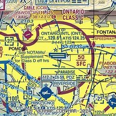
| Sectional chart |
|---|
|
CAUTION: Diagram may not be current
 Download PDF
of official airport diagram from the FAA
| Airport distance calculator |
|---|
|
|
| Sunrise and sunset |
|---|
|
Times for 29-Jul-2026
| | Local
(UTC-7) | | Zulu
(UTC) |
|---|
| Morning civil twilight | | 05:33 | | 12:33 |
| Sunrise | | 06:01 | | 13:01 |
| Sunset | | 19:53 | | 02:53 |
| Evening civil twilight | | 20:21 | | 03:21 |
|
| Current date and time |
|---|
| Zulu (UTC) | 29-Jul-2026 22:54:34 |
|---|
| Local (UTC-7) | 29-Jul-2026 15:54:34 |
|---|
|
| METAR |
|---|
| KONT | 292153Z 24010G17KT 10SM CLR 34/12 A2984 RMK AO2 SLP085 T03440117 $
|
KCNO
4nm S | 292153Z 24012KT 10SM CLR 35/14 A2983 RMK AO2 SLP094 T03500139
|
KCCB
5nm NW | 119.525 909-985-4731
292235Z AUTO 27013KT 10SM CLR 33/12 A2985 RMK AO2
|
KPOC
9nm W | 292147Z 25010KT 10SM CLR 33/14 A2986
|
KAJO
10nm S | 292156Z AUTO 28012G17KT 10SM CLR A2982 RMK AO2 SLPNO FZRANO
|
KRAL
10nm SE | 292153Z 28009G16KT 10SM CLR 35/13 A2982 RMK AO2 SLP080 T03500133
|
KSBD
18nm E | 292153Z 31004KT 10SM CLR 37/03 A2984
|
|
| TAF |
|---|
| KONT | 291720Z 2918/3024 24006KT 6SM HZ SKC FM292000 26010G19KT P6SM SKC FM300400 26006KT P6SM SKC FM301100 VRB03KT 4SM BR OVC007 FM301600 VRB04KT 5SM HZ FEW010 FM302100 26010G18KT P6SM SKC
|
KSBD
18nm E | 291720Z 2918/3018 24006KT 6SM HZ SKC FM292000 26011KT P6SM SKC FM300400 25005KT P6SM SKC FM301200 VRB03KT 4SM BR OVC007 FM301500 VRB04KT 4SM HZ FEW010
|
|
| NOTAMs |
|---|
NOTAMs are issued by the DoD/FAA and will open in a separate window not controlled by AirNav.
|
|


