FAA INFORMATION EFFECTIVE 11 JUNE 2026
Location
| FAA Identifier: | BTP |
| Lat/Long: | 40-46-35.7000N 079-57-03.9000W
40-46.595000N 079-57.065000W
40.7765833,-79.9510833
(estimated) |
| Elevation: | 1248.4 ft. / 380.5 m (surveyed) |
| Variation: | 08W (1985) |
| From city: | 5 miles SW of BUTLER, PA |
| Time zone: | UTC -4 (UTC -5 during Standard Time) |
| Zip code: | 16002 |
Airport Operations
| Airport use: | Open to the public |
| Activation date: | 06/1938 |
| Control tower: | no |
| ARTCC: | CLEVELAND CENTER |
| FSS: | ALTOONA FLIGHT SERVICE STATION |
| NOTAMs facility: | BTP (NOTAM-D service available) |
| Attendance: | MON-FRI 0700-1900, ALL SAT-SUN 0800-1800
UNATNDD CHRISTMAS DAY AND EASTER DAY. |
| Wind indicator: | lighted |
| Segmented circle: | yes |
| Lights: | ACTVT MALSF RWY 08; REIL RWY 26; PAPI RWY 08 & 26; HIRL RWY 08/26 - CTAF. |
| Beacon: | white-green (lighted land airport)
Operates sunset to sunrise. |
| Landing fee: | yes |
Airport Communications
| CTAF/UNICOM: | 123.05 |
| WX AWOS-3PT: | 121.450 (724-586-6434) |
| PITTSBURGH APPROACH: | 124.75 |
| PITTSBURGH DEPARTURE: | 124.75 |
| CLEARANCE DELIVERY: | 119.4 |
| CLASS B: | 124.75 |
| WX AWOS-3PT at PJC (10 nm W): | 118.45 (724-452-5304) |
| WX AWOS-A at 42PN (19 nm S): | PHONE 412-442-2213 |
- COMMUNICATIONS PRVDD BY ALTOONA RADIO ON FREQS 122.1R/115.8T (ELLWOOD CITY RCO).
Nearby radio navigation aids
| VOR radial/distance | | VOR name | | Freq | | Var |
|---|
| EWCr112/12.2 | | ELLWOOD CITY VOR/DME | | 115.80 | | 08W |
| AGCr017/30.2 | | ALLEGHENY VOR/DME | | 110.00 | | 09W |
| FKLr192/(39.9) | | FRANKLIN VOR | | 109.60 | | 06W |
| NDB name | | Hdg/Dist | | Freq | | Var | | ID |
|---|
| CASTLE | | 134/25.7 | | 272 | | 09W | | UCP | ..- -.-. .--. |
Airport Services
| Fuel available: | 100LL JET-A JET-A+
100LL:100LL SELF-SERVE AVBL. |
| Parking: | hangars and tiedowns |
| Airframe service: | MAJOR |
| Powerplant service: | MAJOR |
| Bottled oxygen: | NONE |
| Bulk oxygen: | HIGH/LOW |
Runway Information
Runway 8/26
| Dimensions: | 4801 x 100 ft. / 1463 x 30 m |
| Surface: | asphalt/grooved, in good condition |
| Weight bearing capacity: | | Single wheel: | 37.0 | | Double wheel: | 50.0 |
|
| Runway edge lights: | high intensity |
| RUNWAY 8 | | RUNWAY 26 |
| Latitude: | 40-46.473200N | | 40-46.718085N |
| Longitude: | 079-57.559695W | | 079-56.570728W |
| Elevation: | 1227.7 ft. | | 1243.2 ft. |
| Traffic pattern: | left | | left |
| Runway heading: | 080 magnetic, 072 true | | 260 magnetic, 252 true |
| Markings: | precision, in good condition | | nonprecision, in good condition |
| Visual slope indicator: | 4-light PAPI on left (3.00 degrees glide path) | | 4-light PAPI on left (3.50 degrees glide path) |
| Approach lights: | MALSF: 1,400 foot medium intensity approach lighting system with sequenced flashers | | |
| Runway end identifier lights: | | | yes |
| Touchdown point: | yes, no lights | | yes, no lights |
| Instrument approach: | ILS | | |
| Obstructions: | 52 ft. trees, 957 ft. from runway, 574 ft. right of centerline, 14:1 slope to clear | | 38 ft. trees, 819 ft. from runway, 11 ft. left of centerline, 16:1 slope to clear
RWY 26 PUB ROAD AT THR 455 FT RIGHT. |
Airport Ownership and Management from official FAA records
| Ownership: | Publicly-owned |
| Owner: | BUTLER CO ARPT AUTH
473 AIRPORT RD, SUITE 2
BUTLER, PA 16002
Phone 724-586-6665 |
| Manager: | STEPHANIE SARACCO
473 AIRPORT RD, SUITE 2
BUTLER, PA 16002
Phone 724-586-6665 |
Additional Remarks
| - | NOISE ABATEMENT PROC IN EFCT; CMB TO 2000 FT BFR TURNING. |
| - | DEER AND BIRDS ON AND INVOF ARPT. |
| - | ARPT OFC HRS 0800-1630 M-F, CLSD HOLS. |
Instrument Procedures
NOTE: All procedures below are presented as PDF files. If you need a reader for these files, you should download the free Adobe Reader.NOT FOR NAVIGATION. Please procure official charts for flight.
FAA instrument procedures published for use from 11 June 2026 at 0901Z to 09 July 2026 at 0900z.
IAPs - Instrument Approach Procedures |
|---|
| ILS OR LOC RWY 08 **CHANGED** | |
download (252KB) |
| RNAV (GPS) RWY 08 **CHANGED** | |
download (209KB) |
| RNAV (GPS) RWY 26 **CHANGED** | |
download (202KB) |
| NOTE: Special Alternate Minimums apply | |
download (123KB) |
| NOTE: Special Take-Off Minimums/Departure Procedures apply | |
download (278KB) |
Other nearby airports with instrument procedures:
KPJC - Zelienople Municipal Airport (10 nm W)
6P7 - McVille Airport (16 nm E)
KBVI - Beaver County Airport (20 nm W)
KPIT - Pittsburgh International Airport (21 nm SW)
29D - Grove City Airport (24 nm NW)
|
|

Road maps at:
MapQuest
Bing
Google
| Aerial photo |
|---|
WARNING: Photo may not be current or correct
 Photo by Bill Pixley
Taken in 2017
looking west.
Photo by Bill Pixley
Taken in 2017
looking west.
Do you have a better or more recent aerial photo of Pittsburgh/Butler Regional Airport that you would like to share? If so, please send us your photo.
|
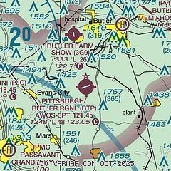
| Sectional chart |
|---|
|
CAUTION: Diagram may not be current

| Airport distance calculator |
|---|
|
|
| Sunrise and sunset |
|---|
|
Times for 26-Jun-2026
| | Local
(UTC-4) | | Zulu
(UTC) |
|---|
| Morning civil twilight | | 05:18 | | 09:18 |
| Sunrise | | 05:51 | | 09:51 |
| Sunset | | 20:54 | | 00:54 |
| Evening civil twilight | | 21:28 | | 01:28 |
|
| Current date and time |
|---|
| Zulu (UTC) | 26-Jun-2026 14:55:10 |
|---|
| Local (UTC-4) | 26-Jun-2026 10:55:10 |
|---|
|
| METAR |
|---|
| KBTP | 261356Z AUTO RMK AO2 SLPNO PWINO FZRANO PNO $
|
|
| TAF |
|---|
KBVI
20nm W | 261130Z 2612/2712 26004KT 2SM BR BKN250 FM261800 VRB04KT P6SM BKN100 FM270200 00000KT 3SM BR OVC018 FM270400 00000KT 3SM -SHRA SCT008 OVC015
|
KPIT
22nm SW | 261130Z 2612/2718 25006KT P6SM BKN150 TEMPO 2612/2614 4SM BR BKN010 FM270300 00000KT 5SM BR OVC025 FM270600 00000KT 3SM -SHRA BR OVC015 FM270900 00000KT 2SM -SHRA SCT008 OVC015
|
|
| NOTAMs |
|---|
NOTAMs are issued by the DoD/FAA and will open in a separate window not controlled by AirNav.
|
|


