FAA INFORMATION EFFECTIVE 09 JULY 2026
Location
| FAA Identifier: | JKA |
| Lat/Long: | 30-17-22.7000N 087-40-18.4000W
30-17.378333N 087-40.306667W
30.2896389,-87.6717778
(estimated) |
| Elevation: | 17.1 ft. / 5.2 m (surveyed) |
| Variation: | 00E (2000) |
| From city: | 2 miles N of GULF SHORES, AL |
| Time zone: | UTC -5 (UTC -6 during Standard Time) |
| Zip code: | 36542 |
Airport Operations
| Airport use: | Open to the public |
| Activation date: | 03/1978 |
| Control tower: | yes |
| ARTCC: | JACKSONVILLE CENTER |
| FSS: | ANNISTON FLIGHT SERVICE STATION |
| NOTAMs facility: | ANB (NOTAM-D service available) |
| Attendance: | 0600-2200
AFT HRS SVC CALL (251) 968-5200. |
| Wind indicator: | lighted |
| Segmented circle: | yes |
| Lights: | WHEN ATCT CLSD ACTVT MALSR RWY 27; PAPI RWYS 09, 27, 17 & 35; HIRL RWY 09/27; MIRL RWY 17/35 - CTAF. |
| Beacon: | white-green (lighted land airport)
Operates sunset to sunrise. |
| Fire and rescue: | ARFF index A |
| Airline operations: | INDEX B AVAILABLE UPON REQUEST CTC ARPT MGMT 850-501-5257. |
| International operations: | customs landing rights airport |
Airport Communications
| CTAF: | 118.65 |
| UNICOM: | 122.7 |
| ATIS: | 134.525 |
| WX AWOS-3PT: | PHONE 251-923-5615 |
| GULF SHORES GROUND: | 121.7 [0700-2100] |
| GULF SHORES TOWER: | 118.65 [0700-2100] |
| PENSACOLA APPROACH: | 120.65 |
| PENSACOLA DEPARTURE: | 120.65 |
| CLEARANCE DELIVERY: | 121.7 124.55 ;WHEN TWR CLSD |
| WX AWOS-3PT at CQF (15 nm NW): | 118.425 (251-928-3242) |
Nearby radio navigation aids
| VOR radial/distance | | VOR name | | Freq | | Var |
|---|
| NUNr237/(20.5) | | SAUFLEY VOR | | 112.25 | | 01E |
| BFMr130/27.7 | | BROOKLEY VORTAC | | 116.35 | | 04E |
Airport Services
| Fuel available: | 100LL JET-A+ |
| Parking: | hangars and tiedowns |
| Airframe service: | MAJOR |
| Powerplant service: | MAJOR |
| Bottled oxygen: | HIGH |
| Bulk oxygen: | HIGH |
Runway Information
Runway 9/27
| Dimensions: | 6962 x 100 ft. / 2122 x 30 m |
| Surface: | asphalt/grooved, in good condition |
| Weight bearing capacity: | | Single wheel: | 80.0 | | Double wheel: | 100.0 |
|
| Runway edge lights: | high intensity |
| RUNWAY 9 | | RUNWAY 27 |
| Latitude: | 30-17.417055N | | 30-17.419230N |
| Longitude: | 087-40.814635W | | 087-39.491140W |
| Elevation: | 15.6 ft. | | 16.1 ft. |
| Traffic pattern: | left | | left |
| Runway heading: | 090 | | 270 |
| Displaced threshold: | 462 ft. | | no |
| Declared distances: | TORA:6962 TODA:6962 ASDA:6962 LDA:6500 | | TORA:6500 TODA:6500 ASDA:6500 LDA:6500 |
| Markings: | nonprecision, in fair condition | | precision, in good condition |
| Visual slope indicator: | 4-light PAPI on left (3.00 degrees glide path) | | 4-light PAPI on left (3.00 degrees glide path) |
| Approach lights: | | | MALSR: 1,400 foot medium intensity approach lighting system with runway alignment indicator lights |
| Touchdown point: | yes, no lights | | yes, no lights |
| Instrument approach: | | | ILS/DME |
| Obstructions: | 84 ft. trees, 2039 ft. from runway, 140 ft. left of centerline, 21:1 slope to clear | | none |
Runway 17/35
| Dimensions: | 3596 x 75 ft. / 1096 x 23 m |
| Surface: | asphalt, in good condition |
| Weight bearing capacity: | | PCN 23 /F/B/X/T | | Single wheel: | 80.0 | | Double wheel: | 100.0 |
|
| Runway edge lights: | medium intensity |
| RUNWAY 17 | | RUNWAY 35 |
| Latitude: | 30-17.595315N | | 30-17.004207N |
| Longitude: | 087-40.634128W | | 087-40.575727W |
| Elevation: | 16.7 ft. | | 11.3 ft. |
| Traffic pattern: | left | | left |
| Runway heading: | 175 | | 355 |
| Displaced threshold: | no | | 320 ft. |
| Declared distances: | TORA:3276 TODA:3276 ASDA:3276 LDA:3276 | | TORA:3596 TODA:3596 ASDA:3596 LDA:3276 |
| Markings: | basic, in good condition | | basic, in good condition |
| Visual slope indicator: | 2-light PAPI on left (3.63 degrees glide path) | | 2-light PAPI on left (4.00 degrees glide path) |
| Touchdown point: | yes, no lights | | yes, no lights |
| Obstructions: | 148 ft. trees, 1427 ft. from runway, 234 ft. left of centerline, 8:1 slope to clear | | 53 ft. tree, 436 ft. from runway, 212 ft. left of centerline, 4:1 slope to clear |
Airport Ownership and Management from official FAA records
| Ownership: | Publicly-owned |
| Owner: | GULF SHORES AIRPORT AUTHORITY
PO BOX 919
GULF SHORES, AL 36547
Phone 251-967-3968 |
| Manager: | JESSE FOSNAUGH
PO BOX 919
GULF SHORES, AL 36547
Phone 251-967-3968 |
Additional Remarks
| A39-09/27 | PCR VALUE: 440/F/B/X/T |
| - | ACR OPNS INVOLVING ACFT WITH MORE THAN 9 PAX SEATS ARE NA IN EXCESS OF 15 MINS BFR OR AFT SKED ARR OR DEP TIMES WO PRIOR CDN WITH ARPT MGMT OR THE ARPT SAFETY DEPT AND CFM THAT ARFF SVCS ARE AVBL PRIOR TO LDG OR TKOF. UNSKED ACR OPNS WITH MORE THAN 30 PAX SEATS SHOULD CTC AMGR (251) 967-3968. |
| - | EXTSV BANNER TOWING, HEL AND PARA-SAIL OPS ALONG COASTLINE 15 NM MILES W TO 20 NM E OF GULF SHORES/ORANGE BEACH, AND 15 NM WSW TO 20 NM ESE OF JKA. |
| - | CAUTION: HOP AT OR BLW 300 FT MSL WI 1 NM OF JKA WHEN LNDG/DEP HELIPAD LCTD 1.6 NM E, DIRECTLY UNDER RWY 27 FINAL. NOLF BARIN LCTD 6 MILES NE OF AP MAY BE MISTAKEN FOR JACK EDWARDS NTL AP. HI VOL OF MIL TFC WILL BE OPRG IN THE BARIN FIELD TFC PAT FROM SFC TO 3000 FT AGL. |
| - | FREQ 122.7 FOR UNICOM USE ONLY. |
Instrument Procedures
NOTE: All procedures below are presented as PDF files. If you need a reader for these files, you should download the free Adobe Reader.NOT FOR NAVIGATION. Please procure official charts for flight.
FAA instrument procedures published for use from 09 July 2026 at 0901Z to 06 August 2026 at 0900Z.
IAPs - Instrument Approach Procedures |
|---|
| ILS OR LOC RWY 27 | |
download (350KB) |
| RNAV (GPS) RWY 09 | |
download (285KB) |
| RNAV (GPS) RWY 27 | |
download (284KB) |
| NOTE: Special Alternate Minimums apply | |
download (153KB) |
| NOTE: Special Take-Off Minimums/Departure Procedures apply | |
download (479KB) |
Other nearby airports with instrument procedures:
5R4 - Holk Field at Foley Municipal Airport (8 nm N)
KCQF - H L Sonny Callahan Airport (15 nm NW)
KNPA - Pensacola Naval Air Station (Forrest Sherman Field) Airport (19 nm E)
KPNS - Pensacola International Airport (27 nm NE)
KBFM - Mobile International Airport (29 nm NW)
|
|

Road maps at:
MapQuest
Bing
Google
| Aerial photo |
|---|
WARNING: Photo may not be current or correct
 Taken in June 2017
looking east.
Taken in June 2017
looking east.
Do you have a better or more recent aerial photo of Gulf Shores International Airport/Jack Edwards Field that you would like to share? If so, please send us your photo.
|
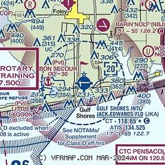
| Sectional chart |
|---|
|
CAUTION: Diagram may not be current

| Airport distance calculator |
|---|
|
|
| Sunrise and sunset |
|---|
|
Times for 25-Jul-2026
| | Local
(UTC-5) | | Zulu
(UTC) |
|---|
| Morning civil twilight | | 05:39 | | 10:39 |
| Sunrise | | 06:06 | | 11:06 |
| Sunset | | 19:48 | | 00:48 |
| Evening civil twilight | | 20:15 | | 01:15 |
|
| Current date and time |
|---|
| Zulu (UTC) | 25-Jul-2026 16:24:14 |
|---|
| Local (UTC-5) | 25-Jul-2026 11:24:14 |
|---|
|
| METAR |
|---|
| KJKA | 251556Z VRB04KT 10SM CLR 33/25 A3012
|
KNBJ
6nm N | 251554Z AUTO 30005KT 10SM CLR 32/24 A3012 RMK AO2 SLP197 T03170239 $
|
KCQF
15nm NW | 251555Z AUTO 32003KT 10SM CLR 30/23 A3014 RMK AO2
|
KNPA
19nm E | 251556Z 34006KT 10SM FEW025 BKN250 32/24 A3012 RMK AO2 SLP199 T03220239 $
|
|
| TAF |
|---|
| KJKA | 251129Z 2512/2612 33003KT P6SM SKC FM251800 26007KT P6SM FEW045 FM252100 22010KT P6SM FEW045 SCT250 FM260200 24005KT P6SM SCT060 SCT250
|
KNPA
19nm E | 2423/2523 21010KT 9999 FEW040 BKN250 QNH3005INS FM250100 VRB03KT 9999 BKN250 QNH3006INS FM251200 32005KT 9999 FEW015 SCT250 QNH3007INS FM251700 16009KT 9999 FEW025 SCT250 QNH3011INS FM252000 21010KT 9999 SCT035 BKN250 QNH3005INS LAST NO AMDS AFT 2423 NEXT 2707 AUTOMATED SENSOR METWATCH TX33/2519Z TN25/2511Z FN20034
|
|
| NOTAMs |
|---|
NOTAMs are issued by the DoD/FAA and will open in a separate window not controlled by AirNav.
|
|


