FAA INFORMATION EFFECTIVE 09 JULY 2026
Location
| FAA Identifier: | MQJ |
| Lat/Long: | 39-50-35.2960N 085-53-51.8480W
39-50.588267N 085-53.864133W
39.8431378,-85.8977356
(estimated) |
| Elevation: | 862.3 ft. / 262.8 m (surveyed) |
| Variation: | 02W (1985) |
| From city: | 12 miles E of INDIANAPOLIS, IN |
| Time zone: | UTC -4 (UTC -5 during Standard Time) |
| Zip code: | 46140 |
Airport Operations
| Airport use: | Open to the public |
| Activation date: | 11/1977 |
| Control tower: | no |
| ARTCC: | INDIANAPOLIS CENTER |
| FSS: | TERRE HAUTE FLIGHT SERVICE STATION |
| NOTAMs facility: | MQJ (NOTAM-D service available) |
| Attendance: | 0600-2200
AVBL AFT HR - 317-335-3371. |
| Wind indicator: | lighted |
| Segmented circle: | yes
LCTD AT MID-FIELD WIND SOCK. |
| Lights: | DUSK-DAWN; ACTVT MALSR RWY 25; HIRL RWY 07/25 - CTAF. |
| Beacon: | white-green (lighted land airport)
Operates sunset to sunrise. |
Airport Communications
| CTAF/UNICOM: | 122.975 |
| WX AWOS-3PT: | 127.950 (317-335-3037) |
| INDIANAPOLIS APPROACH: | 127.15 |
| INDIANAPOLIS DEPARTURE: | 127.15 |
| CLEARANCE DELIVERY: | 119.25 |
| CLANG RNAV STAR: | 128.175 |
| RACYR STAR: | 128.175 |
| WX AWOS-3PT at UMP (9 nm NW): | 119.375 (317-842-3911) |
| WX AWOS-3 at 8A4 (12 nm W): | 135.525 (317-955-3160) |
| WX AWOS-3P at HFY (16 nm SW): | 118.525 (317-882-5862) |
| WX ASOS at GEZ (16 nm S): | 121.55 (317-398-0246) |
| WX ASOS at EYE (18 nm W): | 121.575 (317-329-1754) |
| WX AWOS-3PT at TYQ (20 nm NW): | 120.725 (317-769-3154) |
| WX ASOS at IND (20 nm W): | PHONE 317-220-6243 |
Nearby radio navigation aids
| VOR radial/distance | | VOR name | | Freq | | Var |
|---|
| SHBr344/13.1 | | SHELBYVILLE VOR/DME | | 116.15 | | 01E |
| VHPr084/21.7 | | BRICKYARD VORTAC | | 116.30 | | 01E |
| NDB name | | Hdg/Dist | | Freq | | Var | | ID |
|---|
| NEW CASTLE | | 271/26.8 | | 385 | | 06W | | UWL | ..- .-- .-.. |
Airport Services
| Fuel available: | 100LL JET-A JET-A+ |
| Parking: | hangars and tiedowns |
| Airframe service: | MAJOR |
| Powerplant service: | MAJOR |
| Bottled oxygen: | HIGH/LOW |
Runway Information
Runway 7/25
| Dimensions: | 6005 x 100 ft. / 1830 x 30 m |
| Surface: | asphalt/grooved, in excellent condition |
| Weight bearing capacity: | | Single wheel: | 30.0 | | Double wheel: | 75.0 |
|
| Runway edge lights: | high intensity |
| RUNWAY 7 | | RUNWAY 25 |
| Latitude: | 39-50.195067N | | 39-50.533058N |
| Longitude: | 085-54.670513W | | 085-53.464878W |
| Elevation: | 862.2 ft. | | 858.0 ft. |
| Traffic pattern: | left | | left |
| Runway heading: | 072 magnetic, 070 true | | 252 magnetic, 250 true |
| Markings: | nonprecision, in good condition | | precision, in good condition |
| Visual slope indicator: | 4-light PAPI on left (3.00 degrees glide path) | | 4-light PAPI on left (3.00 degrees glide path) |
| Approach lights: | | | MALSR: 1,400 foot medium intensity approach lighting system with runway alignment indicator lights |
| Runway end identifier lights: | yes | | |
| Touchdown point: | yes, no lights | | yes, no lights |
| Instrument approach: | | | ILS |
Runway 16/34
| Dimensions: | 3902 x 75 ft. / 1189 x 23 m |
| Surface: | concrete, in good condition |
| Weight bearing capacity: | |
| Runway edge lights: | medium intensity |
| RUNWAY 16 | | RUNWAY 34 |
| Latitude: | 39-51.235263N | | 39-50.631282N |
| Longitude: | 085-53.693138W | | 085-53.408412W |
| Elevation: | 857.7 ft. | | 856.9 ft. |
| Traffic pattern: | left | | left |
| Runway heading: | 162 magnetic, 160 true | | 342 magnetic, 340 true |
| Markings: | nonprecision, in good condition | | nonprecision, in good condition |
| Visual slope indicator: | 2-light PAPI on left (3.00 degrees glide path) | | 2-light PAPI on left (3.00 degrees glide path) |
| Runway end identifier lights: | | | yes |
| Touchdown point: | yes, no lights | | yes, no lights |
Helipad H1
| Dimensions: | 40 x 40 ft. / 12 x 12 m |
| Surface: | asphalt, in excellent condition |
| Runway edge lights: | PERI |
| Latitude: | 39-50.673500N | | |
| Longitude: | 085-54.387833W | | |
| Elevation: | 855.0 ft. | | |
| Traffic pattern: | left | | left |
Airport Ownership and Management from official FAA records
| Ownership: | Publicly-owned |
| Owner: | INDIANAPOLIS ARPT AUTHORITY
7800 COL. H. WEIR COOK MEMORIAL DR.
INDIANAPOLIS, IN 46241
Phone 317-487-5022 |
| Manager: | KEITH BERLEN
7800 COL. H. WEIR COOK MEMORIAL DR.
INDIANAPOLIS, IN 46241
Phone 317-487-5022 |
Additional Remarks
| A58-07 | CROPS 250 FT S OF RWY END. |
| A58-16 | CROPS 155 FT FM & 175 FT W OF RWY END. |
| - | RWY 16/34 & TWY B NOT AVBL TO ACR WITH MORE THAN 30 PAX SEATS. |
| - | FOR FUEL & SVC - 131.5 |
| - | FOR CD CTC INDIANAPOLIS APCH AT 317-227-5743. |
Instrument Procedures
NOTE: All procedures below are presented as PDF files. If you need a reader for these files, you should download the free Adobe Reader.NOT FOR NAVIGATION. Please procure official charts for flight.
FAA instrument procedures published for use from 09 July 2026 at 0901Z to 06 August 2026 at 0900Z.
STARs - Standard Terminal Arrivals |
|---|
| CLANG ONE (RNAV) **NEW** | |
download (138KB) |
| RACYR SIX **NEW** | |
download (203KB) |
IAPs - Instrument Approach Procedures |
|---|
| ILS OR LOC RWY 25 **CHANGED** | |
download (255KB) |
| RNAV (GPS) RWY 07 **CHANGED** | |
download (245KB) |
| RNAV (GPS) RWY 16 **CHANGED** | |
download (229KB) |
| RNAV (GPS) RWY 25 **CHANGED** | |
download (281KB) |
| RNAV (GPS) RWY 34 **CHANGED** | |
download (249KB) |
| VOR RWY 34 **CHANGED** | |
download (211KB) |
| NOTE: Special Alternate Minimums apply | |
download (150KB) |
Departure Procedures |
|---|
| DAWNN ONE **CHANGED** | |
2 pages:
[1] [2] (282KB) |
| HOOSIER FIVE **CHANGED** | |
download (216KB) |
| MAREO ONE (RNAV) | |
download (152KB) |
| MEARZ SEVEN **CHANGED** | |
2 pages:
[1] [2] (276KB) |
| ROCKY ONE **CHANGED** | |
download (226KB) |
| NOTE: Special Take-Off Minimums/Departure Procedures apply | |
download (500KB) |
Other nearby airports with instrument procedures:
KUMP - Indianapolis Metro Airport (9 nm NW)
KHFY - Indy South Greenwood Airport (16 nm SW)
KGEZ - Shelbyville Municipal Airport (16 nm S)
KEYE - Eagle Creek Airpark (18 nm W)
KTYQ - Indianapolis Executive Airport (20 nm NW)
KIND - Indianapolis International Airport (20 nm W)
|
|

Road maps at:
MapQuest
Bing
Google
| Aerial photo |
|---|
WARNING: Photo may not be current or correct
 Photo courtesy of Above All Ohio
www.aboveallohio.com
Taken early April 2007
looking NNW
Do you have a better or more recent aerial photo of Indianapolis Regional Airport that you would like to share? If so, please send us your photo.
|
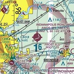
| Sectional chart |
|---|
|
CAUTION: Diagram may not be current

| Airport distance calculator |
|---|
|
|
| Sunrise and sunset |
|---|
|
Times for 24-Jul-2026
| | Local
(UTC-4) | | Zulu
(UTC) |
|---|
| Morning civil twilight | | 06:05 | | 10:05 |
| Sunrise | | 06:36 | | 10:36 |
| Sunset | | 21:04 | | 01:04 |
| Evening civil twilight | | 21:35 | | 01:35 |
|
| Current date and time |
|---|
| Zulu (UTC) | 24-Jul-2026 05:16:52 |
|---|
| Local (UTC-4) | 24-Jul-2026 01:16:52 |
|---|
|
| METAR |
|---|
| KMQJ | 240455Z AUTO 00000KT 10SM SCT055 14/14 A3017 RMK AO2 T01390139 $
|
KUMP
9nm NW | 240455Z AUTO 00000KT 8SM FEW055 16/14 A3018 RMK AO2 T01570142 $
|
KHFY
16nm SW | 240455Z AUTO 00000KT 7SM CLR 15/12 A3017 RMK AO2 T01450115
|
KGEZ
16nm S | 240453Z AUTO 03004KT 10SM BKN055 14/12 A3016 RMK AO2 SLP210 T01440122 402500111
|
KEYE
19nm W | 240453Z AUTO 00000KT 10SM SCT060 17/12 A3016 RMK AO2 SLP209 T01720117 402560128
|
KIND
19nm SW | 240454Z 05004KT 10SM SCT055 BKN250 19/11 A3016 RMK AO2 SLP208 T01940111 402560139
|
KTYQ
20nm NW | 240455Z AUTO 00000KT 10SM BKN060 15/12 A3018 RMK AO2 T01480120
|
|
| TAF |
|---|
KIND
19nm SW | 240250Z 2403/2506 05006KT P6SM SCT250 FM242000 34005KT P6SM BKN250
|
|
| NOTAMs |
|---|
NOTAMs are issued by the DoD/FAA and will open in a separate window not controlled by AirNav.
|
|


