FAA INFORMATION EFFECTIVE 25 DECEMBER 2025
Location
| FAA Identifier: | HFY |
| Lat/Long: | 39-37-39.4000N 086-05-16.9000W
39-37.656667N 086-05.281667W
39.6276111,-86.0880278
(estimated) |
| Elevation: | 822.1 ft. / 250.6 m (surveyed) |
| Variation: | 02W (1990) |
| From city: | 10 miles SE of INDIANAPOLIS, IN |
| Time zone: | UTC -5 (UTC -4 during Daylight Saving Time) |
| Zip code: | 46143 |
Airport Operations
| Airport use: | Open to the public |
| Activation date: | 09/1947 |
| Control tower: | no |
| ARTCC: | INDIANAPOLIS CENTER |
| FSS: | TERRE HAUTE FLIGHT SERVICE STATION |
| NOTAMs facility: | HUF (NOTAM-D service available) |
| Attendance: | MON-SAT 0700-1900, ALL SUN 0800-1700
AFT HR - 317-760-4047. |
| Pattern altitude: | 1622.1 ft. MSL |
| Wind indicator: | lighted |
| Segmented circle: | no |
| Lights: | ACTVT REIL RWY 01; MIRL RWY 01/19 - CTAF. |
| Beacon: | white-green (lighted land airport)
Operates sunset to sunrise. |
Airport Communications
| CTAF/UNICOM: | 123.0 |
| WX AWOS-3P: | 118.525 (317-882-5862) |
| INDIANAPOLIS APPROACH: | 124.95 |
| INDIANAPOLIS DEPARTURE: | 124.95 |
| RACYR STAR: | 128.175 |
| WX AWOS-3 at 8A4 (9 nm N): | 135.525 (317-955-3160) |
| WX ASOS at IND (11 nm NW): | PHONE 317-220-6243 |
| WX ASOS at GEZ (13 nm E): | 121.55 (317-398-0246) |
| WX ASOS at EYE (15 nm NW): | 121.575 (317-329-1754) |
| WX AWOS-3PT at MQJ (16 nm NE): | 124.175 (317-335-3037) |
| WX AWOS-3PT at UMP (19 nm N): | 119.375 (317-842-3911) |
| WX AWOS-3PT at 2R2 (19 nm W): | 118.025 (317-718-4872) |
- APCH/DEP SVC PRVDD BY IND APCH ON 124.95.
Nearby radio navigation aids
| VOR radial/distance | | VOR name | | Freq | | Var |
|---|
| SHBr268/12.2 | | SHELBYVILLE VOR/DME | | 116.15 | | 01E |
| VHPr130/17.1 | | BRICKYARD VORTAC | | 116.30 | | 01E |
| OOMr042/37.9 | | HOOSIER VORTAC | | 110.20 | | 02W |
| NDB name | | Hdg/Dist | | Freq | | Var | | ID |
|---|
| NEW CASTLE | | 253/38.6 | | 385 | | 06W | | UWL | ..- .-- .-.. |
Airport Services
| Fuel available: | 100LL JET-A |
| Parking: | hangars and tiedowns |
| Airframe service: | MAJOR |
| Powerplant service: | MAJOR |
| Bottled oxygen: | HIGH/LOW |
| Bulk oxygen: | HIGH/LOW |
Runway Information
Runway 1/19
| Dimensions: | 5102 x 75 ft. / 1555 x 23 m |
| Surface: | asphalt/grooved, in excellent condition |
| Runway edge lights: | medium intensity |
| Operational restrictions: | 10 FT DITCH 125 FT R & L OF CNTRLN. |
| RUNWAY 1 | | RUNWAY 19 |
| Latitude: | 39-37.240030N | | 39-38.072923N |
| Longitude: | 086-05.353878W | | 086-05.209362W |
| Elevation: | 821.3 ft. | | 819.6 ft. |
| Traffic pattern: | left | | left |
| Runway heading: | 010 magnetic, 008 true | | 190 magnetic, 188 true |
| Displaced threshold: | 102 ft. | | 100 ft. |
| Markings: | nonprecision, in good condition | | nonprecision, in good condition |
| Visual slope indicator: | 4-light PAPI on left (3.00 degrees glide path) | | 4-light PAPI on left (3.00 degrees glide path) |
| Approach lights: | | | ODALS: omnidirectional approach lighting system |
| Runway end identifier lights: | yes | | no |
| Touchdown point: | yes, no lights | | yes, no lights |
| Obstructions: | 36 ft. tree, 1125 ft. from runway, 25:1 slope to clear
APCH RATIO 34:1 AT DTHR. | | 13 ft. road, 570 ft. from runway, 280 ft. right of centerline, 28:1 slope to clear
APCH RATIO 47:1 AT DTHR. |
Airport Ownership and Management from official FAA records
| Ownership: | Publicly-owned |
| Owner: | GREENWOOD BOAC
300 S. MADISON AVE
GREENWOOD, IN 46142
Phone 317-881-0887 |
| Manager: | RICK FERRILL
897 AIRPORT PKWY
GREENWOOD, IN 46143
Phone 317-881-0887 |
Additional Remarks
| - | STUDENT TRNG INVOF ARPT. |
| - | GCO AVBL ON FREQ 121.725 THRU INDIANAPOLIS CLNC AND FLIGHT SERVICES - TO ACTVT 4 SLOW CLICKS. IF UNAVBL CALL 317-227-5743. |
| - | SELF SVC FUEL H24. |
Instrument Procedures
NOTE: All procedures below are presented as PDF files. If you need a reader for these files, you should download the free Adobe Reader.NOT FOR NAVIGATION. Please procure official charts for flight.
FAA instrument procedures published for use from 25 December 2025 at 0901z to 22 January 2026 at 0900z.
STARs - Standard Terminal Arrivals |
|---|
| RACYR SIX | |
download (203KB) |
IAPs - Instrument Approach Procedures |
|---|
| RNAV (GPS) RWY 01 | |
download (231KB) |
| RNAV (GPS) RWY 19 | |
download (238KB) |
| VOR-A | |
download (178KB) |
| NOTE: Special Alternate Minimums apply | |
download (168KB) |
Departure Procedures |
|---|
| DAWNN ONE | |
2 pages:
[1] [2] (280KB) |
| HOOSIER FIVE | |
download (205KB) |
| MAREO FIVE | |
download (196KB) |
| MEARZ SEVEN | |
2 pages:
[1] [2] (266KB) |
| ROCKY ONE | |
download (216KB) |
| NOTE: Special Take-Off Minimums/Departure Procedures apply | |
download (271KB) |
Other nearby airports with instrument procedures:
8A4 - Indianapolis Downtown Heliport (9 nm N)
KIND - Indianapolis International Airport (11 nm NW)
KGEZ - Shelbyville Municipal Airport (13 nm E)
KEYE - Eagle Creek Airpark (15 nm NW)
KMQJ - Indianapolis Regional Airport (16 nm NE)
KUMP - Indianapolis Metro Airport (19 nm N)
2R2 - Hendricks County Airport-Gordon Graham Field (19 nm W)
|
|

Road maps at:
MapQuest
Bing
Google
| Aerial photo |
|---|
WARNING: Photo may not be current or correct
 Photo by Mike Proctor
Photo taken 15-Jun-2007
Photo by Mike Proctor
Photo taken 15-Jun-2007
Do you have a better or more recent aerial photo of Indy South Greenwood Airport that you would like to share? If so, please send us your photo.
|
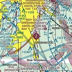
| Sectional chart |
|---|
|
CAUTION: Diagram may not be current

| Airport distance calculator |
|---|
|
|
| Sunrise and sunset |
|---|
|
Times for 19-Jan-2026
| | Local
(UTC-5) | | Zulu
(UTC) |
|---|
| Morning civil twilight | | 07:33 | | 12:33 |
| Sunrise | | 08:03 | | 13:03 |
| Sunset | | 17:48 | | 22:48 |
| Evening civil twilight | | 18:17 | | 23:17 |
|
| Current date and time |
|---|
| Zulu (UTC) | 19-Jan-2026 21:32:46 |
|---|
| Local (UTC-5) | 19-Jan-2026 16:32:46 |
|---|
|
| METAR |
|---|
| KHFY | 192115Z AUTO 27013G26KT 10SM CLR M10/M19 A3030 RMK AO2 T10981192
|
KIND
10nm NW | 192054Z 29016KT 10SM FEW030 M10/M19 A3030 RMK AO2 PK WND 29026/1959 SLP273 T11001189 53015 $
|
KGEZ
14nm E | 192053Z AUTO 29017KT 10SM CLR M09/M19 A3028 RMK AO2 PK WND 28026/2014 SLP267 T10941194 53015
|
KMQJ
16nm NE | 192115Z AUTO 29014KT 10SM FEW036 M11/M18 A3028 RMK AO2 T11071179 $
|
KEYE
16nm NW | 192053Z AUTO 28011G25KT 10SM FEW034 M11/M19 A3029 RMK AO2 SLP272 T11111189 53015
|
KUMP
19nm N | 192115Z AUTO 31014KT 10SM SCT032 M11/M19 A3030 RMK AO2 T11111185
|
|
| TAF |
|---|
KIND
10nm NW | 191741Z 1918/2024 28017G28KT P6SM VCSH SCT030 FM191900 28016G24KT P6SM VCSH FEW020 FM192300 28011KT P6SM FEW140 FEW250 FM200600 26007KT P6SM BKN120 BKN130 FM201200 23005KT P6SM FEW150 FEW250 FM201600 23007KT P6SM FEW170 FEW230
|
|
| NOTAMs |
|---|
NOTAMs are issued by the DoD/FAA and will open in a separate window not controlled by AirNav.
|
|


