FAA INFORMATION EFFECTIVE 09 JULY 2026
Location
| FAA Identifier: | NEW |
| Lat/Long: | 30-02-32.7000N 090-01-41.7000W
30-02.545000N 090-01.695000W
30.0424167,-90.0282500
(estimated) |
| Elevation: | 7.3 ft. / 2.2 m (surveyed) |
| Variation: | 02E (1995) |
| From city: | 4 miles NE of NEW ORLEANS, LA |
| Time zone: | UTC -5 (UTC -6 during Standard Time) |
| Zip code: | 70126 |
Airport Operations
| Airport use: | Open to the public |
| Activation date: | 04/1940 |
| Control tower: | yes |
| ARTCC: | HOUSTON CENTER |
| FSS: | DE RIDDER FLIGHT SERVICE STATION |
| NOTAMs facility: | NEW (NOTAM-D service available) |
| Attendance: | CONTINUOUS |
| Wind indicator: | lighted |
| Segmented circle: | yes |
| Lights: | WHEN TWR CLSD ACTVT MALSR RWY 18R; MIRL RWY 18R/36L; TWY B, C, D, E, F, H, EAST HNGRLN - PRESET LOW INTST. ACTVT 5 CLICKS FOR MED AND 7 CLICKS FOR HIGH - CTAF. |
| Beacon: | white-green (lighted land airport)
FOR ARPT BCN CTC ATCT. |
| International operations: | customs landing rights airport |
Airport Communications
| CTAF: | 118.95 |
| ATIS: | 124.9 |
| WX ASOS: | PHONE 504-245-4366 |
| LAKEFRONT GROUND: | 121.7 335.575 [0700-2100] |
| LAKEFRONT TOWER: | 118.95 [0700-2100] |
| NEW ORLEANS APPROACH: | 123.85 ;SOUTH 133.15 ;NORTH |
| NEW ORLEANS DEPARTURE: | 123.85 ;SOUTH 133.15 ;NORTH |
| CLEARANCE DELIVERY: | 127.4 127.4 ;WHEN NEW TWR CLSD |
| AWDAD STAR: | 125.5 ;WEST |
| MNSTR STAR: | 133.15 ;EAST |
| OLEDD STAR: | 125.5 ;WEST |
| WX ASOS at MSY (12 nm W): | PHONE 504-471-4486 |
- TA35 BASIC RADAR SVC OUTSIDE OF NEW ORLEANS CLASS B BOUNDARIES AVBL.
Nearby radio navigation aids
| VOR radial/distance | | VOR name | | Freq | | Var |
|---|
| HRVr352/11.6 | | HARVEY VORTAC | | 114.10 | | 02E |
| RQRr093/29.2 | | RESERVE VOR/DME | | 110.80 | | 02E |
| PCUr201/34.7 | | PICAYUNE VOR/DME | | 113.95 | | 05E |
Airport Services
| Fuel available: | 100LL JET-A |
| Parking: | hangars and tiedowns |
| Airframe service: | MAJOR |
| Powerplant service: | MAJOR |
| Bottled oxygen: | HIGH |
| Bulk oxygen: | HIGH |
Runway Information
Runway 18R/36L
| Dimensions: | 6879 x 150 ft. / 2097 x 46 m |
| Surface: | asphalt/grooved, in good condition
FEW LOW SPOTS NEAR INTERSECTION OF RY 09/27-HOLDING WATER. |
| Weight bearing capacity: | | Single wheel: | 60.0 | | Double wheel: | 175.0 | | Double tandem: | 200.0 | | Dual double tandem: | 350.0 |
|
| Runway edge lights: | medium intensity |
| RUNWAY 18R | | RUNWAY 36L |
| Latitude: | 30-03.168837N | | 30-02.034073N |
| Longitude: | 090-01.795157W | | 090-01.778350W |
| Elevation: | 5.7 ft. | | 5.7 ft. |
| Traffic pattern: | right | | left |
| Runway heading: | 177 magnetic, 179 true | | 357 magnetic, 359 true |
| Displaced threshold: | 239 ft. | | 820 ft. |
| Declared distances: | TORA:6880 TODA:6880 ASDA:6035 LDA:5510 | | TORA:6880 TODA:6880 ASDA:5955 LDA:5135 |
| Markings: | precision, in good condition | | nonprecision, in good condition |
| Visual slope indicator: | 4-light PAPI on left (3.00 degrees glide path) | | 4-light PAPI on left (3.00 degrees glide path) |
| Approach lights: | MALSR: 1,400 foot medium intensity approach lighting system with runway alignment indicator lights | | |
| Runway end identifier lights: | | | yes |
| Touchdown point: | yes, no lights | | yes, no lights |
| Instrument approach: | ILS/DME | | |
| Obstructions: | 6 ft. other, lighted, 300 ft. from runway, 16:1 slope to clear
APCH RATIO 50:1 FM DSPLCD THR. | | 7 ft. berm, 200 ft. from runway
+7 FT WALL 150 FT FM RY END. |
Runway 18L/36R
| Dimensions: | 3697 x 75 ft. / 1127 x 23 m |
| Surface: | asphalt, in good condition |
| Weight bearing capacity: | | Single wheel: | 35.0 | | Double wheel: | 55.0 | | Double tandem: | 80.0 |
|
| Runway edge lights: | medium intensity |
| RUNWAY 18L | | RUNWAY 36R |
| Latitude: | 30-03.011097N | | 30-02.401223N |
| Longitude: | 090-01.660290W | | 090-01.650973W |
| Elevation: | 5.2 ft. | | 6.7 ft. |
| Traffic pattern: | left | | right |
| Runway heading: | 177 magnetic, 179 true | | 357 magnetic, 359 true |
| Declared distances: | TORA:3697 TODA:3697 ASDA:3697 LDA:3697 | | TORA:3697 TODA:3697 ASDA:3697 LDA:3697 |
| Markings: | basic, in good condition | | basic, in good condition |
| Visual slope indicator: | | | 4-light PAPI on left (3.00 degrees glide path)
RWY 36R PAPI UNUSBL BTN 2100 AND 0700 LOCAL |
| Runway end identifier lights: | yes | | yes |
| Touchdown point: | yes, no lights | | yes, no lights |
| Obstructions: | none | | 54 ft. bldg, lighted, 2035 ft. from runway, 35 ft. left of centerline, 33:1 slope to clear |
Runway 9/27
| Dimensions: | 3114 x 75 ft. / 949 x 23 m |
| Surface: | asphalt, in fair condition |
| Weight bearing capacity: | | Single wheel: | 50.0 | | Double wheel: | 80.0 | | Double tandem: | 100.0 |
|
| Runway edge lights: | medium intensity |
| RUNWAY 9 | | RUNWAY 27 |
| Latitude: | 30-02.222937N | | 30-02.230278N |
| Longitude: | 090-01.837077W | | 090-01.246788W |
| Elevation: | 4.9 ft. | | 4.7 ft. |
| Traffic pattern: | left | | right |
| Runway heading: | 087 magnetic, 089 true | | 267 magnetic, 269 true |
| Declared distances: | TORA:3113 TODA:3113 ASDA:3113 LDA:3113 | | TORA:3113 TODA:3113 ASDA:3113 LDA:3113 |
| Markings: | basic, in good condition | | basic, in fair condition |
| Visual slope indicator: | 4-light PAPI on left (3.00 degrees glide path) | | 4-light PAPI on right (3.20 degrees glide path) |
| Runway end identifier lights: | yes | | |
| Touchdown point: | yes, no lights | | yes, no lights |
| Obstructions: | 4 ft. berm, lighted, 267 ft. from runway, 16:1 slope to clear | | 14 ft. road, 543 ft. from runway, 161 ft. right of centerline, 24:1 slope to clear |
Airport Ownership and Management from official FAA records
| Ownership: | Publicly-owned |
| Owner: | ORLEANS LEVEE DISTRICT
6001 STARS AND STRIPES BLVD, SUITE 204
NEW ORLEANS, LA 70126
Phone 504-243-4010 |
| Manager: | BRUCE MARTIN
6001 STARS & STRIPES BLVD, SUITE 204
NEW ORLEANS, LA 70126
Phone 504-243-4010 |
Additional Remarks
| - | PPR REQUIRED FOR ACFT TRNSPG ANY ITEMS LISTED IN PART 175 TITLE 49. CONTACT 504-606-9264 |
| - | TWY A UNEVEN PAVEMENT. |
| - | FOR ASSTNC AFTER 2100 LOCAL CTC AMGR 504-874-0459 |
| - | FOR FICONS AFTER HRS CALL ARFF 504-606-9264. |
| - | BOAT MASTS UP TO 80 FT WI 0.5NM OF AER RWY 27. |
| - | ARPT WINDCONE FOR BALL PARK RAMP LGTS OTS PERMLY. |
| - | CAUTION TWY F BTN TRML RAMP AND FLT LN FST RAMP IREG SFC. |
| - | FOR CD WHEN ATCT IS CLSD CTC MSY APCH AT 504-471-4350 OR 127.4 |
| - | CTC ARPT MGR FOR DSGND RAMP SPACE FOR PUB USE AT ARPT |
| - | BIRDS ON & INVOF ARPT. |
| - | BOATS AS HIGH AS 80 FT PASS WI 400 FT OF RWY 09 THLD. |
| - | ARFF CPBLTY EQUIVALENT TO INDEX B. |
| - | FUEL NOT AVAILABLE WITHIN 100' OF TERMINAL BUILDING |
Instrument Procedures
NOTE: All procedures below are presented as PDF files. If you need a reader for these files, you should download the free Adobe Reader.NOT FOR NAVIGATION. Please procure official charts for flight.
FAA instrument procedures published for use from 09 July 2026 at 0901Z to 06 August 2026 at 0900Z.
STARs - Standard Terminal Arrivals |
|---|
| AWDAD ONE **NEW** | |
download (209KB) |
| MNSTR TWO (RNAV) **NEW** | |
2 pages:
[1] [2] (342KB) |
| OLEDD FOUR **NEW** | |
download (149KB) |
| TRSSH TWO (RNAV) **NEW** | |
2 pages:
[1] [2] (297KB) |
| TRSSH TWO (RNAV), CONT.2 **NEW** | |
download (199KB) |
IAPs - Instrument Approach Procedures |
|---|
| ILS OR LOC RWY 18R | |
download (297KB) |
| RNAV (GPS) RWY 18R | |
download (297KB) |
| RNAV (GPS) RWY 36L | |
download (306KB) |
| VOR/DME RWY 36L | |
download (282KB) |
| NOTE: Special Alternate Minimums apply | |
download (158KB) |
| NOTE: Special Take-Off Minimums/Departure Procedures apply | |
download (301KB) |
Other nearby airports with instrument procedures:
KMSY - Louis Armstrong New Orleans International Airport (12 nm W)
KNBG - New Orleans Naval Air Station Joint Reserve Base - Alvin Callender Field (13 nm S)
KASD - Slidell Airport (21 nm NE)
KAPS - Port of South Louisiana Executive Regional Airport (29 nm W)
KMJD - Picayune Municipal Airport (33 nm NE)
|
|

Road maps at:
MapQuest
Bing
Google
| Aerial photo |
|---|
WARNING: Photo may not be current or correct
 Photo by Tom Gresham
Photo taken 25-Apr-2020
looking northeast.
Photo by Tom Gresham
Photo taken 25-Apr-2020
looking northeast.
Do you have a better or more recent aerial photo of Lakefront Airport that you would like to share? If so, please send us your photo.
|
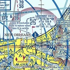
| Sectional chart |
|---|
|
CAUTION: Diagram may not be current
 Download PDF
of official airport diagram from the FAA
| Airport distance calculator |
|---|
|
|
| Sunrise and sunset |
|---|
|
Times for 24-Jul-2026
| | Local
(UTC-5) | | Zulu
(UTC) |
|---|
| Morning civil twilight | | 05:49 | | 10:49 |
| Sunrise | | 06:15 | | 11:15 |
| Sunset | | 19:58 | | 00:58 |
| Evening civil twilight | | 20:24 | | 01:24 |
|
| Current date and time |
|---|
| Zulu (UTC) | 25-Jul-2026 00:37:24 |
|---|
| Local (UTC-5) | 24-Jul-2026 19:37:24 |
|---|
|
| METAR |
|---|
| KNEW | 242353Z 16007KT 10SM CLR 31/24 A3008 RMK AO1 SLP180 T03110239 10328 20278 53001
|
KMSY
12nm W | 242353Z 17003KT 10SM SCT040 SCT075 BKN250 31/24 A3007 RMK AO2 RAE2256 SLP187 P0000 60000 T03060239 10339 20300 53005
|
KNBG
14nm S | 242355Z 16005KT 10SM SCT036 BKN044 BKN250 31/23 A3008 RMK AO2 SLP184 T03110233 10333 20311 53006
|
KASD
18nm NE | 242353Z AUTO 21004KT 10SM CLR 31/22 A3006 RMK AO2 SLP180 T03110222 10339 20311 56000
|
|
| TAF |
|---|
| KNEW | 241720Z 2418/2518 VRB05KT P6SM SCT030
|
KMSY
12nm W | 241720Z 2418/2524 19005KT P6SM FEW030 SCT250
|
KNBG
14nm S | TAF KNBG 2423/2523 18006KT 9999 SCT022 SCT250 QNH3000INS BECMG 2504/2506 VRB04KT 9999 SCT030 SCT250 QNH3003INS BECMG 2511/2513 29005KT 9999 BKN030 BKN250 QNH2999INS AUTOMATED SENSOR METWATCH 2504 TIL 2510 TX34/2519Z TN23/2511Z FN20093
|
KASD
18nm NE | 241720Z 2418/2518 VRB04KT P6SM SKC
|
|
| NOTAMs |
|---|
NOTAMs are issued by the DoD/FAA and will open in a separate window not controlled by AirNav.
|
|


