FAA INFORMATION EFFECTIVE 09 JULY 2026
Location
| FAA Identifier: | PYP |
| Lat/Long: | 34-05-23.7000N 085-36-36.3000W
34-05.395000N 085-36.605000W
34.0899167,-85.6100833
(estimated) |
| Elevation: | 594.6 ft. / 181 m (estimated) |
| Variation: | 04W (2010) |
| From city: | 5 miles S of CENTRE, AL |
| Time zone: | UTC -5 (UTC -6 during Standard Time) |
| Zip code: | 35960 |
Airport Operations
| Airport use: | Open to the public |
| Activation date: | 09/2007 |
| Control tower: | no |
| ARTCC: | ATLANTA CENTER |
| FSS: | ANNISTON FLIGHT SERVICE STATION |
| NOTAMs facility: | ANB (NOTAM-D service available) |
| Attendance: | MON-FRI 0800-1600 |
| Wind indicator: | lighted |
| Segmented circle: | yes |
| Lights: | ACTVT MIRL RWY 07/25 - CTAF. |
| Beacon: | white-green (lighted land airport)
Operates sunset to sunrise. |
Airport Communications
- APCH/DEP SVC PRVDD BY ATLANTA ARTCC ON FREQS 124.5/270.325 (GADSDEN RCAG).
Nearby radio navigation aids
| VOR radial/distance | | VOR name | | Freq | | Var |
|---|
| GADr072/24.5 | | GADSDEN VOR/DME | | 112.30 | | 02E |
| RMGr259/24.8 | | ROME VORTAC | | 115.40 | | 01E |
| NDB name | | Hdg/Dist | | Freq | | Var | | ID |
|---|
| CARROLLTON | | 327/39.5 | | 278 | | 04W | | GPQ | --. .--. --.- |
Airport Services
| Fuel available: | 100LL |
| Parking: | tiedowns |
Runway Information
Runway 7/25
| Dimensions: | 5500 x 100 ft. / 1676 x 30 m |
| Surface: | asphalt/aggregate friction seal coat, in fair condition |
| Runway edge lights: | medium intensity |
| Runway edge markings: | RWY IDENTIFIER, CENTERLINE FADED |
| RUNWAY 7 | | RUNWAY 25 |
| Latitude: | 34-05.189240N | | 34-05.601052N |
| Longitude: | 085-37.089855W | | 085-36.118890W |
| Elevation: | 584.4 ft. | | 594.6 ft. |
| Traffic pattern: | left | | left |
| Runway heading: | 067 magnetic, 063 true | | 247 magnetic, 243 true |
| Markings: | nonprecision, in fair condition | | nonprecision, in poor condition |
| Touchdown point: | yes, no lights | | yes, no lights |
| Obstructions: | 75 ft. trees, 2777 ft. from runway, 43 ft. left of centerline, 34:1 slope to clear | | none |
Airport Ownership and Management from official FAA records
| Ownership: | Publicly-owned |
| Owner: | CPCCR AIRPORT AUTHORITY
P.O. BOX 466, 8850 ALABAMA HWY 9 S
CENTRE, AL 35960
Phone 256-927-8009 |
| Manager: | DONNIE FREE
P.O. 466, 8850 ALABAMA HWY 9 S
CENTRE, AL 35960
Phone 256-927-8009 |
Additional Remarks
| A39-07/25 | PCR VALUE: 90/F/D/X/T |
| - | FOR CD CTC ATLANTA ARTCC AT 770-210-7692. |
Instrument Procedures
NOTE: All procedures below are presented as PDF files. If you need a reader for these files, you should download the free Adobe Reader.NOT FOR NAVIGATION. Please procure official charts for flight.
FAA instrument procedures published for use from 09 July 2026 at 0901Z to 06 August 2026 at 0900Z.
IAPs - Instrument Approach Procedures |
|---|
| RNAV (GPS) RWY 07 | |
download (230KB) |
| RNAV (GPS) RWY 25 | |
download (204KB) |
| NOTE: Special Take-Off Minimums/Departure Procedures apply | |
download (517KB) |
Other nearby airports with instrument procedures:
4A4 - Polk County Airport/Cornelius Moore Field (24 nm E)
4A9 - Isbell Field Airport (24 nm N)
KGAD - Northeast Alabama Regional Airport (25 nm W)
KRMG - Richard B. Russell Regional Airport - J.H. Towers Field (27 nm NE)
KANB - Anniston Regional Airport (33 nm S)
|
|

Road maps at:
MapQuest
Bing
Google
| Aerial photo |
|---|
WARNING: Photo may not be current or correct
 Photo by Harley McGatha
Photo taken 10-Nov-2007
from a PA24-260B Comanche
Photo by Harley McGatha
Photo taken 10-Nov-2007
from a PA24-260B Comanche
Do you have a better or more recent aerial photo of Centre Piedmont/Cherokee County Regional Airport that you would like to share? If so, please send us your photo.
|
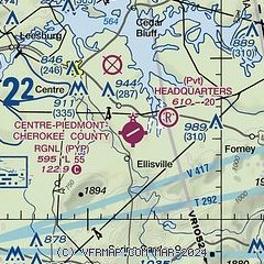
| Sectional chart |
|---|
|
| Airport distance calculator |
|---|
|
|
| Sunrise and sunset |
|---|
|
Times for 01-Aug-2026
| | Local
(UTC-5) | | Zulu
(UTC) |
|---|
| Morning civil twilight | | 05:27 | | 10:27 |
| Sunrise | | 05:55 | | 10:55 |
| Sunset | | 19:43 | | 00:43 |
| Evening civil twilight | | 20:10 | | 01:10 |
|
| Current date and time |
|---|
| Zulu (UTC) | 01-Aug-2026 15:00:47 |
|---|
| Local (UTC-5) | 01-Aug-2026 10:00:47 |
|---|
|
| METAR |
|---|
K4A9
24nm N | 011435Z AUTO 24006KT 7SM OVC012 25/24 A2988 RMK AO2 LTG DSNT NE AND NW T02480238
|
KRMG
27nm NE | 011453Z AUTO 00000KT 8SM BKN041 OVC060 24/23 A2987 RMK AO2 RAB33E51 SLP104 P0002 60002 T02440228 58003
|
KANB
33nm S | 011453Z AUTO 00000KT 10SM OVC055 24/23 A2988 RMK AO2 LTG DSNT S RAE14 TSE1355 SLP109 P0002 60007 T02440233 58007
|
KBFZ
33nm W | 011435Z AUTO 22010KT 10SM BKN013 OVC017 27/25 A2987 RMK AO2
|
KPUJ
35nm E | 011435Z AUTO VRB04KT 10SM SCT100 25/23 A2991 RMK AO2
|
KCTJ
36nm SE | 011435Z AUTO 00000KT 10SM BKN010 BKN120 25/22 A2995 RMK AO2 T02510224
|
KVPC
38nm E | 011435Z AUTO 00000KT 10SM 27/22 A2989 RMK AO2
|
KASN
38nm SW | 011435Z AUTO VRB04KT 10SM OVC050 25/25 A2986 RMK AO2
|
K9A5
39nm NE | 011435Z AUTO 24004KT 4SM BR BKN013 OVC037 24/23 A2988 RMK AO2 T02370225
|
KCZL
40nm NE | 011435Z AUTO 16005KT 10SM SCT050 SCT080 BKN100 27/22 A2987 RMK AO2
|
|
| NOTAMs |
|---|
NOTAMs are issued by the DoD/FAA and will open in a separate window not controlled by AirNav.
|
|

