FAA INFORMATION EFFECTIVE 19 FEBRUARY 2026
Location
| FAA Identifier: | LZU |
| Lat/Long: | 33-58-41.1310N 083-57-44.5100W
33-58.685517N 083-57.741833W
33.9780919,-83.9623639
(estimated) |
| Elevation: | 1061.5 ft. / 323.5 m (surveyed) |
| Variation: | 05W (2010) |
| From city: | 2 miles NE of LAWRENCEVILLE, GA |
| Time zone: | UTC -5 (UTC -4 during Daylight Saving Time) |
| Zip code: | 30045 |
Airport Operations
| Airport use: | Open to the public |
| Activation date: | 10/1963 |
| Control tower: | yes |
| ARTCC: | ATLANTA CENTER |
| FSS: | MACON FLIGHT SERVICE STATION |
| NOTAMs facility: | LZU (NOTAM-D service available) |
| Attendance: | CONTINUOUS |
| Pattern altitude: | 2100.5 ft. MSL
TPA FOR LIGHT ACFT 1039 FT; TPA FOR JET & TURBO PROP ACFT 1539 FT. |
| Wind indicator: | lighted, SECONDARY WIND ANEMOMETER SENSOR ON FIELD SUPPORTING ATCT OPS. |
| Segmented circle: | yes |
| Lights: | WHEN ATCT CLSD ACTVT MALSR RWY 25; HIRL RWY 07/25 - CTAF. PAPI RWY 07 & 25 OPR CONSLY. |
| Beacon: | white-green (lighted land airport)
Operates sunset to sunrise. |
Airport Communications
| CTAF: | 124.1 |
| UNICOM: | 123.05 |
| ATIS: | 132.275 |
| WX AWOS-3PT: | PHONE 770-339-7753 |
| GWINNETT GROUND: | 121.8 [0700-2100] |
| GWINNETT TOWER: | 124.1 [0700-2100] |
| ATLANTA APPROACH: | 126.975 |
| ATLANTA DEPARTURE: | 126.975 |
| CLEARANCE DELIVERY: | 121.8 134.0 ;WHEN TWR CLSD |
| BOKRT STAR: | 119.8 |
| WRGNZ STAR: | 128.575 |
| WX AWOS-3 at WDR (15 nm E): | 118.575 (770-868-0642) |
| WX AWOS-3PT at D73 (18 nm SE): | 120.825 (678-635-3668) |
| WX ASOS at PDK (18 nm W): | 128.4 (770-457-1691) |
| WX ASOS at GVL (19 nm N): | 126.475 (770-532-4687) |
Nearby radio navigation aids
| VOR radial/distance | | VOR name | | Freq | | Var |
|---|
| AHNr273/31.8 | | ATHENS VOR/DME | | 116.95 | | 00E |
| NDB name | | Hdg/Dist | | Freq | | Var | | ID |
|---|
| GWNET | | 248/5.5 | | 419 | | 05W | | TX | - -..- |
| BARROW COUNTY | | 283/18.7 | | 404 | | 05W | | BMW | -... -- .-- |
Airport Services
| Fuel available: | 100LL JET-A+ |
| Parking: | tiedowns |
| Airframe service: | MAJOR |
| Powerplant service: | MAJOR |
| Bottled oxygen: | LOW |
| Bulk oxygen: | LOW |
Runway Information
Runway 7/25
| Dimensions: | 6001 x 100 ft. / 1829 x 30 m |
| Surface: | asphalt/grooved, in good condition |
| Weight bearing capacity: | | PCN 37 /F/D/W/T | | Single wheel: | 93.0 | | Double wheel: | 120.0 |
|
| Runway edge lights: | high intensity |
| RUNWAY 7 | | RUNWAY 25 |
| Latitude: | 33-58.466287N | | 33-58.904710N |
| Longitude: | 083-58.274090W | | 083-57.209522W |
| Elevation: | 1061.5 ft. | | 1031.3 ft. |
| Traffic pattern: | left | | left |
| Runway heading: | 069 magnetic, 064 true | | 249 magnetic, 244 true |
| Markings: | precision, in good condition | | precision, in good condition |
| Visual slope indicator: | 2-light PAPI on left (3.00 degrees glide path) | | 2-light PAPI on left (3.00 degrees glide path) |
| Approach lights: | | | MALSR: 1,400 foot medium intensity approach lighting system with runway alignment indicator lights |
| Touchdown point: | yes, no lights | | yes, no lights |
| Instrument approach: | | | ILS |
| Obstructions: | 48 ft. pole, 1160 ft. from runway, 511 ft. right of centerline, 20:1 slope to clear | | 10 ft. trees, 301 ft. from runway, 505 ft. left of centerline, 10:1 slope to clear |
Airport Ownership and Management from official FAA records
| Ownership: | Publicly-owned |
| Owner: | GWINNETT COUNTY
75 LANGELY DR
LAWRENCEVILLE, GA 30046
Phone 770-822-7000 |
| Manager: | MATTHEW SMITH
600 BRISCOE BLVD
LAWRENCEVILLE, GA 30046
Phone 770-822-5196 |
Additional Remarks
| - | TWY T HAS NSTD MARKING. |
Instrument Procedures
NOTE: All procedures below are presented as PDF files. If you need a reader for these files, you should download the free Adobe Reader.NOT FOR NAVIGATION. Please procure official charts for flight.
FAA instrument procedures published for use from 19 February 2026 at 0901Z to 19 March 2026 at 0900Z.
STARs - Standard Terminal Arrivals |
|---|
| BOKRT THREE (RNAV) | |
download (186KB) |
| BUKHD THREE (RNAV) | |
download (190KB) |
| DEHAN THREE (RNAV) | |
2 pages:
[1] [2] (327KB) |
| SWTEE TWO (RNAV) | |
download (142KB) |
| WRGNZ THREE (RNAV) | |
download (246KB) |
IAPs - Instrument Approach Procedures |
|---|
| ILS OR LOC RWY 25 | |
download (253KB) |
| RNAV (GPS) RWY 07 | |
download (222KB) |
| RNAV (GPS) RWY 25 | |
download (243KB) |
| NOTE: Special Alternate Minimums apply | |
download (157KB) |
| NOTE: Special Take-Off Minimums/Departure Procedures apply | |
download (479KB) |
Other nearby airports with instrument procedures:
KWDR - Barrow County Airport (15 nm E)
D73 - Cy Nunnally Memorial Airport (18 nm SE)
KPDK - Dekalb-Peachtree Airport (18 nm W)
KGVL - Lee Gilmer Memorial Airport (19 nm N)
KCVC - Covington Municipal Airport (22 nm S)
|
|

Road maps at:
MapQuest
Bing
Google
| Aerial photo |
|---|
WARNING: Photo may not be current or correct
 Photo courtesy of AirNav, LLC
Photo taken 02-Mar-2017
looking northeast.
Photo courtesy of AirNav, LLC
Photo taken 02-Mar-2017
looking northeast.
Do you have a better or more recent aerial photo of Gwinnett County Airport-Briscoe Field that you would like to share? If so, please send us your photo.
|
| Sectional chart |
|---|
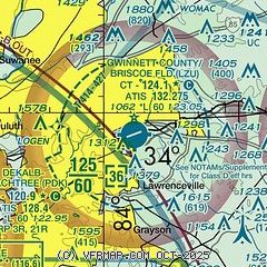
|
CAUTION: Diagram may not be current
 Download PDF
of official airport diagram from the FAA
| Airport distance calculator |
|---|
|
|
| Sunrise and sunset |
|---|
|
Times for 16-Mar-2026
| | Local
(UTC-4) | | Zulu
(UTC) |
|---|
| Morning civil twilight | | 07:21 | | 11:21 |
| Sunrise | | 07:46 | | 11:46 |
| Sunset | | 19:43 | | 23:43 |
| Evening civil twilight | | 20:08 | | 00:08 |
|
| Current date and time |
|---|
| Zulu (UTC) | 16-Mar-2026 18:21:10 |
|---|
| Local (UTC-4) | 16-Mar-2026 14:21:10 |
|---|
|
| METAR |
|---|
| KLZU | 161756Z 28015G21KT 10SM -RA BKN012 BKN070 05/04 A2974 RMK AO2 SLP080 P0000 60001 T00500039 10144 20050 51017 $
|
KWDR
15nm E | 161555Z 10SM OVC012 10/08 A2972 RMK AO2 P0001 LTG DSNT SE AND S
|
KPDK
18nm W | 161753Z 27012G20KT 10SM BKN013 OVC075 05/02 A2977 RMK AO2 RAB15E46 SLP080 P0000 60001 T00500017 51015
|
KD73
18nm SE | 161555Z AUTO 4SM -RA BR OVC007 10/ A2971 RMK AO2 P0002 T0104////
|
KGVL
18nm N | 161801Z AUTO 27011G21KT 5SM -RA SCT010 OVC017 06/03 A2972 RMK AO2 P0000 T00610033
|
|
| TAF |
|---|
KPDK
18nm W | 161729Z 1618/1718 29018G28KT P6SM BKN020 BKN035 PROB30 1618/1620 6SM -SNPL FM162100 29017G27KT P6SM BKN045 FM170100 31011G21KT P6SM SCT250 FM170400 30011KT P6SM SCT060 FM171600 29011KT P6SM FEW250
|
|
| NOTAMs |
|---|
NOTAMs are issued by the DoD/FAA and will open in a separate window not controlled by AirNav.
|
|


