FAA INFORMATION EFFECTIVE 11 JUNE 2026
Location
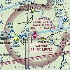
| FAA Identifier: | RSV |
| Lat/Long: | 39-00-57.7000N 087-38-59.2000W
39-00.961667N 087-38.986667W
39.0160278,-87.6497778
(estimated) |
| Elevation: | 461.3 ft. / 140.6 m (surveyed) |
| Variation: | 03W (2015) |
| From city: | 4 miles E of ROBINSON, IL |
| Time zone: | UTC -5 (UTC -6 during Standard Time) |
| Zip code: | 62451 |
Airport Operations
| Airport use: | Open to the public |
| Activation date: | 10/1951 |
| Control tower: | no |
| ARTCC: | INDIANAPOLIS CENTER |
| FSS: | SAINT LOUIS FLIGHT SERVICE STATION |
| NOTAMs facility: | RSV (NOTAM-D service available) |
| Attendance: | MON-FRI 0900-1700 |
| Pattern altitude: | 1261.3 ft. MSL |
| Wind indicator: | lighted |
| Segmented circle: | yes |
| Lights: | MIRL RY 09/27 PRESET ON LOW INTST; TO INCR INTST & ACTVT MIRL RY 17/35 , REIL RYS 09, 27 & 17 PVASI RYS 09 & 27 - CTAF. |
| Beacon: | white-green (lighted land airport)
Operates sunset to sunrise. |
Airport Communications
| CTAF/UNICOM: | 123.0 |
| WX AWOS-3: | 120.50 (618-586-2772) |
| HULMAN APPROACH: | 135.35 |
| HULMAN DEPARTURE: | 135.35 |
| WX ASOS at LWV (15 nm S): | 118.0 (618-943-5252) |
Nearby radio navigation aids
| VOR radial/distance | | VOR name | | Freq | | Var |
|---|
| TTHr211/33.9 | | TERRE HAUTE VORTAC | | 115.30 | | 02E |
| BIBr079/39.2 | | BIBLE GROVE VORTAC | | 109.00 | | 03E |
| NDB name | | Hdg/Dist | | Freq | | Var | | ID |
|---|
| OLNEY | | 057/30.3 | | 272 | | 03W | | OLY | --- .-.. -.-- |
Airport Services
| Fuel available: | 100LL JET-A |
| Parking: | hangars and tiedowns |
| Airframe service: | MAJOR |
| Powerplant service: | MAJOR |
| Bottled oxygen: | NONE |
| Bulk oxygen: | NONE |
Runway Information
Runway 9/27
| Dimensions: | 5108 x 100 ft. / 1557 x 30 m |
| Surface: | asphalt, in good condition |
| Weight bearing capacity: | | Single wheel: | 35.0 | | Double wheel: | 50.0 | | Double tandem: | 65.0 |
|
| Runway edge lights: | medium intensity |
| RUNWAY 9 | | RUNWAY 27 |
| Latitude: | 39-00.998477N | | 39-00.971877N |
| Longitude: | 087-39.659542W | | 087-38.581415W |
| Elevation: | 461.3 ft. | | 454.5 ft. |
| Traffic pattern: | left | | left |
| Runway heading: | 095 magnetic, 092 true | | 275 magnetic, 272 true |
| Markings: | nonprecision, in good condition | | nonprecision, in good condition |
| Visual slope indicator: | pulsating/steady burning VASI on left (3.00 degrees glide path) | | pulsating/steady burning VASI on left (3.00 degrees glide path) |
| Runway end identifier lights: | yes | | yes |
| Touchdown point: | yes, no lights | | yes, no lights |
Runway 17/35
| Dimensions: | 3398 x 75 ft. / 1036 x 23 m |
| Surface: | asphalt, in good condition |
| Weight bearing capacity: | |
| Runway edge lights: | medium intensity |
| RUNWAY 17 | | RUNWAY 35 |
| Latitude: | 39-01.198290N | | 39-00.655550N |
| Longitude: | 087-38.874592W | | 087-38.698660W |
| Elevation: | 455.3 ft. | | 452.0 ft. |
| Traffic pattern: | left | | left |
| Runway heading: | 169 magnetic, 166 true | | 349 magnetic, 346 true |
| Markings: | nonprecision, in good condition | | nonprecision, in good condition |
| Runway end identifier lights: | yes | | no |
| Touchdown point: | yes, no lights | | yes, no lights |
Airport Ownership and Management from official FAA records
| Ownership: | Publicly-owned |
| Owner: | CRAWFORD COUNTY ARPT AUTHORITY
10748 NORTH 1650 ST
PALESTINE, IL 62451
Phone 618-586-2121 |
| Manager: | HOWARD HUNT
10748 NORTH 1650 ST
PALESTINE, IL 62451
Phone 217-932-2078 |
Additional Remarks
| - | FOR CD CTC HULMAN APCH AT 812-877-7581. |
Instrument Procedures
NOTE: All procedures below are presented as PDF files. If you need a reader for these files, you should download the free Adobe Reader.NOT FOR NAVIGATION. Please procure official charts for flight.
FAA instrument procedures published for use from 11 June 2026 at 0901Z to 09 July 2026 at 0900z.
IAPs - Instrument Approach Procedures |
|---|
| RNAV (GPS) RWY 09 | |
download (235KB) |
| RNAV (GPS) RWY 17 | |
download (206KB) |
| RNAV (GPS) RWY 27 | |
download (232KB) |
| NOTE: Special Alternate Minimums apply | |
download (163KB) |
| NOTE: Special Take-Off Minimums/Departure Procedures apply | |
download (478KB) |
Other nearby airports with instrument procedures:
KSIV - Sullivan County Airport (11 nm NE)
KLWV - Lawrenceville-Vincennes International Airport (15 nm S)
1H8 - Casey Municipal Airport (24 nm NW)
KAJG - Mount Carmel Municipal Airport (25 nm S)
KOLY - Olney-Noble Airport (30 nm SW)
|
|

Road maps at:
MapQuest
Bing
Google
| Aerial photo |
|---|

|
| Sectional chart |
|---|
|
| Airport distance calculator |
|---|
|
|
| Sunrise and sunset |
|---|
|
Times for 21-Jun-2026
| | Local
(UTC-5) | | Zulu
(UTC) |
|---|
| Morning civil twilight | | 04:54 | | 09:54 |
| Sunrise | | 05:26 | | 10:26 |
| Sunset | | 20:19 | | 01:19 |
| Evening civil twilight | | 20:51 | | 01:51 |
|
| Current date and time |
|---|
| Zulu (UTC) | 21-Jun-2026 09:45:33 |
|---|
| Local (UTC-5) | 21-Jun-2026 04:45:33 |
|---|
|
| METAR |
|---|
| KRSV | 210935Z AUTO 09002KT 10SM OVC060 17/17 A2994 RMK AO2
|
KLWV
15nm S | 210853Z AUTO 06003KT 10SM BKN055 BKN080 19/17 A2994 RMK AO2 SLP135 T01940172 55002
|
|
| TAF |
|---|
KHUF
30nm NE | 210525Z 2106/2206 VRB02KT P6SM BKN250 FM211300 13005KT P6SM BKN120 FM211700 14009KT P6SM BKN060 FM212000 15011KT 6SM -SHRA BR BKN050 TEMPO 2120/2124 3SM TSRA BR OVC020CB FM220000 16011KT 5SM -SHRA BR VCTS BKN030CB
|
|
| NOTAMs |
|---|
NOTAMs are issued by the DoD/FAA and will open in a separate window not controlled by AirNav.
|
|

