FAA INFORMATION EFFECTIVE 22 JANUARY 2026
Location
| FAA Identifier: | VGT |
| Lat/Long: | 36-12-38.5305N 115-11-39.9955W
36-12.642175N 115-11.666592W
36.2107029,-115.1944432
(estimated) |
| Elevation: | 2205 ft. / 672.1 m (surveyed) |
| Variation: | 14E (1995) |
| From city: | 3 miles NW of LAS VEGAS, NV |
| Time zone: | UTC -8 (UTC -7 during Daylight Saving Time) |
| Zip code: | 89032 |
Airport Operations
| Airport use: | Open to the public |
| Activation date: | 01/1942 |
| Control tower: | yes |
| ARTCC: | LOS ANGELES CENTER |
| FSS: | RENO FLIGHT SERVICE STATION |
| NOTAMs facility: | VGT (NOTAM-D service available) |
| Attendance: | 0500-2230 |
| Pattern altitude: | 3005 ft. MSL |
| Wind indicator: | lighted |
| Segmented circle: | yes |
| Lights: | WHEN ATCT CLSD ACTVT REIL RWY 07 & 25, 12L & 30R, 12R & 30L; PAPI RWY 07 & 25, 12L & 30R, 12R & 30L; MIRL RWY 07/25, 12L/30R, 12R/30L; TWY LGTS - CTAF. |
| Beacon: | white-green (lighted land airport)
Operates sunset to sunrise. |
| Airline operations: | ARFF INDEX A, 139.315 (E) |
Airport Communications
| CTAF: | 125.7 |
| UNICOM: | 122.95 |
| ATIS: | 118.05 |
| WX ASOS: | 118.05 (702-648-6633) |
| NORTH LAS VEGAS GROUND: | 121.7 [0600-2000 OCT-MAR; 0600-2100 APR-SEP] |
| NORTH LAS VEGAS TOWER: | 125.7 360.75 119.15 [0600-2000 OCT-MAR; 0600-2100 APR-SEP] |
| LAS VEGAS APPROACH: | 119.4 118.125 ;RWY 12 |
| LAS VEGAS DEPARTURE: | 119.4 |
| CLEARANCE DELIVERY: | 124.0 |
| NTNDO RNAV STAR: | 125.475 |
| WX ASOS at LAS (8 nm S): | PHONE 702-582-5334 |
| WX AWOS-3PT at HND (15 nm S): | 120.775 (702-614-4537) |
- VGT TWR FREQUENCY 119.15 MAY BE USED FOR RWT 12L/30R OPS.
- ALL IFR VISUAL APCH GO-AROUNDS EXPCET CLSD TFC AT VGT.
Nearby radio navigation aids
| VOR radial/distance | | VOR name | | Freq | | Var |
|---|
| LASr333/8.0 | | LAS VEGAS VORTAC | | 116.90 | | 15E |
| BLDr294/20.6 | | BOULDER CITY VORTAC | | 116.70 | | 15E |
Airport Services
| Fuel available: | 100LL JET-A |
| Parking: | tiedowns |
| Airframe service: | MAJOR |
| Powerplant service: | MAJOR |
| Bulk oxygen: | HIGH |
Runway Information
Runway 7/25
| Dimensions: | 5005 x 75 ft. / 1526 x 23 m |
| Surface: | asphalt, in good condition |
| Weight bearing capacity: | | PCN 58 /F/C/X/T | | Single wheel: | 30.0 |
|
| Runway edge lights: | medium intensity |
| RUNWAY 7 | | RUNWAY 25 |
| Latitude: | 36-12.797712N | | 36-12.817910N |
| Longitude: | 115-12.202430W | | 115-11.184988W |
| Elevation: | 2204.2 ft. | | 2172.5 ft. |
| Traffic pattern: | left | | left |
| Runway heading: | 074 magnetic, 088 true | | 254 magnetic, 268 true |
| Declared distances: | TORA:5005 TODA:5005 ASDA:5005 LDA:5005 | | TORA:5005 TODA:5005 ASDA:5005 LDA:5005 |
| Markings: | basic, in good condition | | basic, in good condition |
| Visual slope indicator: | 4-light PAPI on left (3.00 degrees glide path) | | 4-light PAPI on left (3.00 degrees glide path) |
| Runway end identifier lights: | yes | | yes |
| Touchdown point: | yes, no lights | | yes, no lights |
| Obstructions: | 50 ft. pole, 1434 ft. from runway, 24:1 slope to clear | | none |
Runway 12R/30L
| Dimensions: | 5000 x 75 ft. / 1524 x 23 m |
| Surface: | asphalt, in good condition |
| Weight bearing capacity: | | PCN 48 /F/C/X/T | | Single wheel: | 30.0 |
|
| Runway edge lights: | medium intensity |
| RUNWAY 12R | | RUNWAY 30L |
| Latitude: | 36-12.880637N | | 36-12.304867N |
| Longitude: | 115-12.159957W | | 115-11.432563W |
| Elevation: | 2205.0 ft. | | 2163.0 ft. |
| Traffic pattern: | left | | left |
| Runway heading: | 120 magnetic, 134 true | | 300 magnetic, 314 true |
| Declared distances: | TORA:5000 TODA:5000 ASDA:5000 LDA:5000 | | TORA:5000 TODA:5000 ASDA:5000 LDA:5000 |
| Markings: | nonprecision, in good condition | | nonprecision, in good condition |
| Visual slope indicator: | 4-light PAPI on left (3.00 degrees glide path) | | 4-light PAPI on left (3.00 degrees glide path) |
| Runway end identifier lights: | yes | | yes |
| Touchdown point: | yes, no lights | | yes, no lights |
| Obstructions: | 45 ft. bldg, 1500 ft. from runway, 28:1 slope to clear | | none |
Runway 12L/30R
| Dimensions: | 4199 x 75 ft. / 1280 x 23 m |
| Surface: | asphalt, in good condition |
| Weight bearing capacity: | | PCN 15 /F/C/X/T | | Single wheel: | 30.0 |
|
| Runway edge lights: | medium intensity |
| RUNWAY 12L | | RUNWAY 30R |
| Latitude: | 36-12.745343N | | 36-12.261780N |
| Longitude: | 115-11.785152W | | 115-11.174485W |
| Elevation: | 2188.6 ft. | | 2145.1 ft. |
| Traffic pattern: | left | | left |
| Runway heading: | 120 magnetic, 134 true | | 300 magnetic, 314 true |
| Displaced threshold: | no | | 199 ft. |
| Declared distances: | TORA:4199 TODA:4199 ASDA:4199 LDA:4199 | | TORA:4199 TODA:4199 ASDA:4199 LDA:4000 |
| Markings: | precision, in good condition | | basic, in good condition |
| Visual slope indicator: | 4-light PAPI on left (3.20 degrees glide path) | | 4-light PAPI on left (3.00 degrees glide path) |
| Runway end identifier lights: | yes | | yes |
| Touchdown point: | yes, no lights | | yes, no lights |
| Instrument approach: | ILS/DME | | |
| Obstructions: | 45 ft. bldg, 2019 ft. from runway, 45:1 slope to clear | | none |
Airport Ownership and Management from official FAA records
| Ownership: | Publicly-owned |
| Owner: | CLARK COUNTY
2730 AIRPORT DR SUITE 101
NORTH LAS VEGAS, NV 89032
Phone 702-261-3803 |
| Manager: | KARINA TARNOWSKA
2730 AIRPORT DR SUITE 101
NORTH LAS VEGAS, NV 89032
Phone 702-261-3804
MGR. ALSO 702-261-3802. 702.261.3804, NORTH LAS VEGAS AIRPORT 2730 AIRPORT DRIVE, SUITE 101 NORTH LAS VEGAS, NV 89032 |
Additional Remarks
| - | AIMING POINT MKD AT 1000 FT - ALL RWYS. |
| - | RWY GUARD LGTS AT ALL INTXNS. |
| - | FOR CD WHEN ATCT IS CLSD CTC LAS APCH ON 124.0 OR PH 725-200-4432. |
| - | WHEN SPL EVENT PRKG PPR PROGRAM NOTAM IS ACTV, TSNT ACFT OPERS NOT PERM BASED NEED TO OBTAIN A PPR NR FM AN FBO FOR EA LDG. PPR APPVL & CONFIRMATION NRS CAN BE OBTAINED FM THE SEL FBO AT 702-261-7775. PPR CONFIRMATION NRS SHOULD BE ENTERED IN THE RMKS SECTION OF EACH FLT PLAN. |
| - | RWY 12R CALM WIND RWY. |
Instrument Procedures
NOTE: All procedures below are presented as PDF files. If you need a reader for these files, you should download the free Adobe Reader.NOT FOR NAVIGATION. Please procure official charts for flight.
FAA instrument procedures published for use from 22 January 2026 at 0901Z to 19 February 2026 at 0900z.
STARs - Standard Terminal Arrivals |
|---|
| FLCHR ONE (RNAV) | |
download (134KB) |
| NTNDO ONE (RNAV) | |
download (185KB) |
| WYLND ONE (RNAV) | |
download (142KB) |
IAPs - Instrument Approach Procedures |
|---|
| ILS OR LOC RWY 12L | |
download (409KB) |
| RNAV (GPS) RWY 12R | |
download (403KB) |
| NOTE: Special Alternate Minimums apply | |
download (141KB) |
Departure Procedures |
|---|
| NORTHTOWN FIVE | |
download (224KB) |
|
|---|
| BOULDER CITY ONE (OBSTACLE) | |
download (357KB) |
| NOTE: Special Take-Off Minimums/Departure Procedures apply | |
download (113KB) |
Other nearby airports with instrument procedures:
KLSV - Nellis Air Force Base (8 nm E)
KLAS - Harry Reid International Airport (8 nm S)
KHND - Henderson Executive Airport (15 nm S)
KBVU - Boulder City Municipal Airport (23 nm SE)
67L - Mesquite Airport (66 nm NE)
|
|

Road maps at:
MapQuest
Bing
Google
| Aerial photo |
|---|
WARNING: Photo may not be current or correct
 Photo taken 10-Mar-2007
Do you have a better or more recent aerial photo of North Las Vegas Airport that you would like to share? If so, please send us your photo.
|
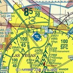
| Sectional chart |
|---|
|
CAUTION: Diagram may not be current
 Download PDF
of official airport diagram from the FAA
| Airport distance calculator |
|---|
|
|
| Sunrise and sunset |
|---|
|
Times for 28-Jan-2026
| | Local
(UTC-8) | | Zulu
(UTC) |
|---|
| Morning civil twilight | | 06:19 | | 14:19 |
| Sunrise | | 06:46 | | 14:46 |
| Sunset | | 17:02 | | 01:02 |
| Evening civil twilight | | 17:29 | | 01:29 |
|
| Current date and time |
|---|
| Zulu (UTC) | 28-Jan-2026 10:56:35 |
|---|
| Local (UTC-8) | 28-Jan-2026 02:56:35 |
|---|
|
| METAR |
|---|
| KVGT | 280953Z AUTO 30003KT 10SM CLR 05/M09 A3031 RMK AO2 SLP284 T00501089
|
KLAS
8nm S | 280956Z 23004KT 10SM BKN230 06/M12 A3032 RMK AO2 SLP266 T00611117
|
KLSV
9nm E | 280955Z 00000KT 10SM BKN220 03/M10 A3029 RMK AO2A SLP257 T00271096 $
|
KHND
14nm S | 280956Z AUTO 17008KT 10SM CLR 04/M12 A3033 RMK AO2 SLP290 T00391122 $
|
|
| TAF |
|---|
| KVGT | 280520Z 2806/2906 32006KT P6SM SCT150 BKN200 FM281500 VRB06KT P6SM FEW120 BKN150 FM282200 12006KT P6SM FEW200 SCT250 FM290300 28006KT P6SM FEW150 SCT200
|
KLAS
8nm S | 280833Z 2809/2912 24005KT P6SM SCT150 BKN200 FM281400 VRB05KT P6SM FEW120 BKN150 FM282000 10006KT P6SM FEW200 SCT250 FM290300 25006KT P6SM FEW150 SCT200
|
KLSV
9nm E | 280700Z 2807/2913 VRB06KT 9999 BKN160 QNH3026INS BECMG 2821/2822 15008KT 9999 BKN220 QNH3024INS BECMG 2904/2905 33009KT 9999 FEW250 QNH3025INS TX17/2823Z TN03/2815Z
|
KHND
14nm S | 280520Z 2806/2906 18007KT P6SM SCT150 BKN200 FM281500 VRB05KT P6SM FEW120 BKN150 FM282100 03006KT P6SM FEW200 SCT250 FM290200 18006KT P6SM FEW150 SCT200
|
|
| NOTAMs |
|---|
NOTAMs are issued by the DoD/FAA and will open in a separate window not controlled by AirNav.
|
|


