FAA INFORMATION EFFECTIVE 19 MARCH 2026
Location
| FAA Identifier: | W00 |
| Lat/Long: | 38-56-28.8670N 076-46-20.5790W
38-56.481117N 076-46.342983W
38.9413519,-76.7723831
(estimated) |
| Elevation: | 168.1 ft. / 51.2 m (surveyed) |
| Variation: | 10W (1995) |
| From city: | 2 miles NW of BOWIE, MD |
| Time zone: | UTC -4 (UTC -5 during Standard Time) |
| Zip code: | 20721 |
Airport Operations
| Airport use: | Open to the public |
| Activation date: | 06/1961 |
| Control tower: | no |
| ARTCC: | WASHINGTON CENTER |
| FSS: | LEESBURG FLIGHT SERVICE STATION |
| NOTAMs facility: | DCA (NOTAM-D service available) |
| Attendance: | 0800-1700
UNATNDD MAJOR HOLIDAYS. |
| Wind indicator: | lighted |
| Segmented circle: | yes |
| Lights: | ACTVT PAPI RWYS 18 & 36; MIRL RWY 18/36 - CTAF. |
| Beacon: | white-green (lighted land airport)
Operates sunset to sunrise. |
Airport Communications
| CTAF/UNICOM: | 123.075 |
| POTOMAC APPROACH: | 128.0 ;DC SFRA |
| POTOMAC DEPARTURE: | 128.0 ;DC SFRA |
| IRONS STAR: | 126.4 |
| TIKEE STAR: | 120.45 |
| WX AWOS-3 at CGS (7 nm W): | 121.225 (301-864-5497) |
| WX AWOS-3 at FME (9 nm N): | 123.925 |
| WX ASOS at DCA (14 nm SW): | 132.65 (276-200-0159) |
| WX ASOS at BWI (15 nm N): | PHONE 227-217-0474 |
Nearby radio navigation aids
| VOR radial/distance | | VOR name | | Freq | | Var |
|---|
| ADWr039/9.2 | | ANDREWS VORTAC | | 113.10 | | 10W |
| DCAr077/13.3 | | WASHINGTON VOR/DME | | 111.00 | | 09W |
| BALr212/14.7 | | BALTIMORE VORTAC | | 115.10 | | 11W |
| AMLr097/32.4 | | ARMEL VOR/DME | | 113.50 | | 08W |
| EMIr172/34.6 | | WESTMINSTER VORTAC | | 117.90 | | 08W |
| FDKr143/39.8 | | FREDERICK VOR/DME | | 116.85 | | 08W |
| NDB name | | Hdg/Dist | | Freq | | Var | | ID |
|---|
| OXONN | | 060/15.9 | | 332 | | 11W | | VQK | ...- --.- -.- |
| GEORGETOWN | | 097/16.4 | | 323 | | 09W | | GTN | --. - -. |
| ELLICOTT | | 190/20.8 | | 371 | | 11W | | FND | ..-. -. -.. |
Airport Services
| Fuel available: | 100LL
100LL:100LL AVBL WHEN ATNDD. |
| Parking: | tiedowns |
| Airframe service: | MAJOR |
| Powerplant service: | MAJOR |
| Bottled oxygen: | NONE |
| Bulk oxygen: | NONE |
Runway Information
Runway 18/36
| Dimensions: | 2420 x 40 ft. / 738 x 12 m |
| Surface: | asphalt, in fair condition |
| Runway edge lights: | medium intensity |
| RUNWAY 18 | | RUNWAY 36 |
| Latitude: | 38-56.678667N | | 38-56.285833N |
| Longitude: | 076-46.386167W | | 076-46.299667W |
| Elevation: | 168.1 ft. | | 151.6 ft. |
| Traffic pattern: | left | | right |
| Runway heading: | 180 magnetic, 170 true | | 000 magnetic, 350 true |
| Displaced threshold: | no | | 230 ft. |
| Markings: | nonprecision, in fair condition | | nonprecision, in fair condition |
| Visual slope indicator: | 2-light PAPI on right (6.00 degrees glide path) | | 2-light PAPI on left (5.50 degrees glide path) |
| Touchdown point: | yes, no lights | | yes, no lights |
| Obstructions: | 67 ft. trees, marked and lighted, 848 ft. from runway, 164 ft. left of centerline, 9:1 slope to clear
+7 FT ROAD AT 115 FT OUT, OB. | | 48 ft. trees, 569 ft. from runway, 90 ft. left of centerline, 7:1 slope to clear
+18 FT TREES AT 175 FT OUT, 22 FT R. |
Airport Ownership and Management from official FAA records
| Ownership: | Privately-owned |
| Owner: | FREEWAY AIRPORT INC.
3900 CHURCH RD
BOWIE, MD 20721
Phone 301-390-6424 |
| Manager: | MATTHEW LINDQUIST
3900 CHURCH RD
MITCHELLVILLE, MD 20716
Phone 301-390-6424 |
Additional Remarks
| - | TPA 1000 FT MSL (832 FT AGL) FOR ACFT LESS THAN 4000 LBS MAX GWT; TPA 1200 FT MSL (1032 FT AGL) FOR ACFT GREATER THAN 4000 LBS. |
| - | -15 FT DROP 80 FT FROM APCH TO RWY 36. |
| - | -7 FT DROP 50 FT FM APCH END RWY 18. |
| - | UNLGTD ANTENNA 135 FT AGL 600 FT NW AER 18. |
| - | FOR CD CTC POTOMAC APCH AT 866-599-3874. |
| - | TWY RUNUP AREA FOR RWY 36 CLSD. |
Instrument Procedures
NOTE: All procedures below are presented as PDF files. If you need a reader for these files, you should download the free Adobe Reader.NOT FOR NAVIGATION. Please procure official charts for flight.
FAA instrument procedures published for use from 19 March 2026 at 0901Z to 16 April 2026 at 0900Z.
STARs - Standard Terminal Arrivals |
|---|
| TIKEE FOUR (RNAV) | |
download (216KB) |
IAPs - Instrument Approach Procedures |
|---|
| RNAV (GPS) RWY 18 | |
download (208KB) |
| RNAV (GPS) RWY 36 | |
download (214KB) |
| NOTE: Special Take-Off Minimums/Departure Procedures apply | |
download (245KB) |
Other nearby airports with instrument procedures:
KCGS - College Park Airport (7 nm W)
KFME - Fort Meade Executive Airport (9 nm N)
KADW - Joint Base Andrews (9 nm SW)
KANP - Lee Airport (10 nm E)
KDCA - Ronald Reagan Washington National Airport (14 nm SW)
KVKX - Potomac Airfield (14 nm SW)
KBWI - Baltimore/Washington International Thurgood Marshall Airport (15 nm N)
|
|

Road maps at:
MapQuest
Bing
Google
| Aerial photo |
|---|
WARNING: Photo may not be current or correct
 Photo taken 19-Oct-2016
looking northeast.
Photo taken 19-Oct-2016
looking northeast.
Do you have a better or more recent aerial photo of Freeway Airport that you would like to share? If so, please send us your photo.
|
| Sectional chart |
|---|
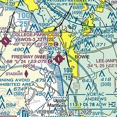
|
| Airport distance calculator |
|---|
|
|
| Sunrise and sunset |
|---|
|
Times for 25-Mar-2026
| | Local
(UTC-4) | | Zulu
(UTC) |
|---|
| Morning civil twilight | | 06:37 | | 10:37 |
| Sunrise | | 07:04 | | 11:04 |
| Sunset | | 19:23 | | 23:23 |
| Evening civil twilight | | 19:49 | | 23:49 |
|
| Current date and time |
|---|
| Zulu (UTC) | 25-Mar-2026 06:06:23 |
|---|
| Local (UTC-4) | 25-Mar-2026 02:06:23 |
|---|
|
| METAR |
|---|
KCGS
7nm W | 250555Z AUTO 17007KT 10SM CLR 06/M02 A3038 RMK AO2 T00611019 10080 20047
|
KFME
9nm N | 250555Z AUTO 17003KT 10SM CLR 03/M01 A3040 RMK AO1
|
KADW
9nm SW | 250555Z AUTO 19010KT 10SM CLR 05/M01 A3037 RMK AO2 SLP292 T00491011 10081 20041 58001 $
|
KDCA
13nm SW | 250552Z 20013KT 10SM BKN120 OVC200 06/M01 A3038 RMK AO2 SLP285 T00611006 10094 20061 58001
|
KNAK
14nm E | 250554Z AUTO 18006KT 10SM CLR 06/M02 A3039 RMK AO2 SLP292 T00561017 10067 20056 58001 $
|
KBWI
14nm N | 250554Z 20004KT 10SM BKN120 OVC150 05/M03 A3037 RMK AO2 SLP284 T00501033 10067 20044 58001 $
|
|
| TAF |
|---|
KADW
9nm SW | 241700Z 2417/2523 VRB06KT 9999 FEW040 QNH3044INS BECMG 2421/2422 18010KT 9999 SCT100 BKN180 QNH3043INS BECMG 2503/2504 18010G18KT 9999 BKN080 OVC150 QNH3037INS BECMG 2518/2519 17010KT 9999 OVC100 QNH3026INS TX12/2516Z TN02/2510Z
|
KDCA
13nm SW | 250250Z 2503/2606 17011KT P6SM BKN250 FM250400 18005KT P6SM SCT120 BKN250 FM251600 18008KT P6SM SCT200
|
KBWI
14nm N | 250250Z 2503/2606 14003KT P6SM SCT200 FM250400 17002KT P6SM SCT120 BKN250 FM251600 18008KT P6SM SCT200
|
|
| NOTAMs |
|---|
NOTAMs are issued by the DoD/FAA and will open in a separate window not controlled by AirNav.
|
|

