FAA INFORMATION EFFECTIVE 09 JULY 2026
Location
| FAA Identifier: | X51 |
| Lat/Long: | 25-29-57.2170N 080-33-15.2880W
25-29.953617N 080-33.254800W
25.4992269,-80.5542467
(estimated) |
| Elevation: | 7 ft. / 2.1 m (surveyed) |
| Variation: | 06W (2010) |
| From city: | 4 miles NW of HOMESTEAD, FL |
| Time zone: | UTC -4 (UTC -5 during Standard Time) |
| Zip code: | 33030 |
Airport Operations
| Airport use: | Open to the public |
| Activation date: | 04/1963 |
| Control tower: | no |
| ARTCC: | MIAMI CENTER |
| FSS: | MIAMI FLIGHT SERVICE STATION |
| NOTAMs facility: | MIA (NOTAM-D service available) |
| Attendance: | 0800-1800 |
| Wind indicator: | lighted |
| Segmented circle: | yes |
| Lights: | SS-SR |
| Beacon: | white-green (lighted land airport)
Operates sunset to sunrise. |
Airport Communications
| CTAF/UNICOM: | 122.8 |
| WX AWOS-3: | 118.375 (321-385-0383) |
| MIAMI APPROACH: | 125.5 [0700-2300] |
| MIAMI DEPARTURE: | 125.5 [0700-2300] |
| ALTNN DP: | 125.5 |
| BNFSH STAR: | 124.85 |
| BNGOS DP: | 125.5 |
| CSTAL STAR: | 124.85 |
| DORRL DP: | 125.5 |
| FLMGO DP: | 125.5 |
| FOLZZ DP: | 125.5 |
| FOWEE STAR: | 120.5 |
| FROGZ STAR: | 120.5 |
| HURCN DP: | 125.5 |
| LIFRR DP: | 125.5 |
| LUUCE STAR: | 126.05 ;9000 FT 133.775 ;7000 FT |
| MAYNR DP: | 125.5 |
| MELLZ DP: | 125.5 |
| PALMZ STAR: | 120.5 |
| SNDBR STAR: | 120.5 |
| TARPN STAR: | 126.05 ;9000 FT 133.775 ;7000 FT 124.6 ;12000 FT |
| VACAY DP: | 125.5 |
| VIICE STAR: | 120.5 |
| WX ASOS at TMB (11 nm NE): | 124.0 (305-235-1332) |
| WX AWOS-3T at 07FA (18 nm SE): | 119.025 (305-367-3013) |
Nearby radio navigation aids
| VOR radial/distance | | VOR name | | Freq | | Var |
|---|
| DHPr216/21.2 | | DOLPHIN VORTAC | | 113.90 | | 04W |
| VKZr239/26.4 | | VIRGINIA KEY VOR/DME | | 117.10 | | 04W |
Airport Services
| Fuel available: | 100LL JET-A |
| Parking: | hangars and tiedowns |
| Airframe service: | MAJOR |
| Powerplant service: | MAJOR |
| Bottled oxygen: | LOW |
Runway Information
Runway 18/36
| Dimensions: | 4001 x 100 ft. / 1220 x 30 m |
| Surface: | asphalt, in good condition |
| Weight bearing capacity: | | PCN 12 /F/A/Y/T | | Single wheel: | 40.0 | | Double wheel: | 65.0 | | Double tandem: | 110.0 |
|
| Runway edge lights: | medium intensity |
| RUNWAY 18 | | RUNWAY 36 |
| Latitude: | 25-30.125280N | | 25-29.464865N |
| Longitude: | 080-33.423990W | | 080-33.417450W |
| Elevation: | 6.9 ft. | | 7.0 ft. |
| Traffic pattern: | right | | left |
| Runway heading: | 185 magnetic, 179 true | | 005 magnetic, 359 true |
| Markings: | basic, in fair condition | | basic, in fair condition |
| Visual slope indicator: | | | 4-light PAPI on right (3.00 degrees glide path) |
| Touchdown point: | yes, no lights | | yes, no lights |
Runway 10/28
| Dimensions: | 3000 x 75 ft. / 914 x 23 m |
| Surface: | asphalt/grooved, in excellent condition |
| Weight bearing capacity: | | PCN 5 /F/A/Y/T | | Single wheel: | 20.0 |
|
| Runway edge lights: | medium intensity |
| RUNWAY 10 | | RUNWAY 28 |
| Latitude: | 25-30.163920N | | 25-30.166612N |
| Longitude: | 080-33.305860W | | 080-32.760742W |
| Elevation: | 6.0 ft. | | 6.9 ft. |
| Traffic pattern: | left | | right |
| Runway heading: | 096 magnetic, 090 true | | 276 magnetic, 270 true |
| Markings: | nonprecision, in good condition | | nonprecision, in good condition |
| Visual slope indicator: | 2-light PAPI on left (3.00 degrees glide path) | | |
| Touchdown point: | yes, no lights | | yes, no lights |
| Obstructions: | 22 ft. tree, 1270 ft. from runway, 225 ft. right of centerline | | none |
Runway 9U/27U
| Dimensions: | 2500 x 150 ft. / 762 x 46 m |
| Surface: | turf, in fair condition |
| Runway edge markings: | MKD WITH WHITE CONES. |
| RUNWAY 9U | | RUNWAY 27U |
| Traffic pattern: | left | | left |
| Markings: | NSTD, in fair condition | | NSTD, in fair condition |
| Obstructions: | 46 ft. trees, 2270 ft. from runway, 40 ft. left of centerline | | none |
Airport Ownership and Management from official FAA records
| Ownership: | Publicly-owned |
| Owner: | MIAMI-DADE COUNTY
MIAMI-DADE AVIATION DEPT, P.O. BOX 025504
MIAMI, FL 33102-5504
Phone 305-876-7038
CONTACT PERSON: LIONEL BECKLES |
| Manager: | JOSEPH KINNEBREW
12800 SOUTHWEST 145TH AVENUE
MIAMI, FL 33186
Phone 305-876-7484 |
Additional Remarks
| - | PAJA SE CORNER OF ARPT . |
| - | 24 HR PPR FOR ACFT EQUIPPED WITH WEATHER MODIFICATION OR GEOENGINEERING EQPT 305-247-4883 |
| - | AEROBATIC BOX S OF ARPT & E OF RWY 18/36. |
| - | REMOTE CTL MODEL FLYING FLDS 1.8 NM N RWY 18. |
| - | GLIDER ACT 8000 FT & BLW & CROP DUSTING INVOF ARPT. |
| - | FOR CD CTC MIAMI APCH AT 305-869-5432. |
Instrument Procedures
NOTE: All procedures below are presented as PDF files. If you need a reader for these files, you should download the free Adobe Reader.NOT FOR NAVIGATION. Please procure official charts for flight.
FAA instrument procedures published for use from 09 July 2026 at 0901Z to 06 August 2026 at 0900Z.
STARs - Standard Terminal Arrivals |
|---|
| BNFSH THREE (RNAV) **NEW** | |
2 pages:
[1] [2] (513KB) |
| BNFSH THREE (RNAV), CONT.2 **NEW** | |
download (262KB) |
| CSTAL THREE (RNAV) **NEW** | |
2 pages:
[1] [2] (417KB) |
| CSTAL THREE (RNAV), CONT.2 **NEW** | |
download (353KB) |
| FOWEE TWO **NEW** | |
download (181KB) |
| FROGZ FIVE (RNAV) **NEW** | |
2 pages:
[1] [2] (535KB) |
| FROGZ FIVE (RNAV), CONT.2 **NEW** | |
download (406KB) |
| PALMZ TWO **NEW** | |
download (185KB) |
| SNDBR THREE (RNAV) **NEW** | |
2 pages:
[1] [2] (467KB) |
| TARPN THREE (RNAV) **NEW** | |
download (213KB) |
| VIICE TWO (RNAV) **NEW** | |
2 pages:
[1] [2] (368KB) |
| VIICE TWO (RNAV), CONT.2 **NEW** | |
download (159KB) |
IAPs - Instrument Approach Procedures |
|---|
| RNAV (GPS) RWY 10 | |
download (231KB) |
| RNAV (GPS) RWY 28 | |
download (195KB) |
Departure Procedures |
|---|
| ALTNN TWO (RNAV) | |
download (240KB) |
| BNGOS FOUR (RNAV) | |
download (260KB) |
| DORRL TWO (RNAV) | |
download (236KB) |
| FLMGO TWO (RNAV) | |
download (244KB) |
| FOLZZ THREE (RNAV) | |
download (286KB) |
| HURCN FOUR (RNAV) | |
2 pages:
[1] [2] (310KB) |
| LIFRR TWO (RNAV) | |
download (233KB) |
| MAYNR THREE (RNAV) | |
2 pages:
[1] [2] (296KB) |
| MELLZ TWO (RNAV) | |
download (240KB) |
| NOTE: Special Take-Off Minimums/Departure Procedures apply | |
download (264KB) |
Other nearby airports with instrument procedures:
KHST - Homestead Air Reserve Base (9 nm E)
KTMB - Miami Executive Airport (11 nm NE)
07FA - Ocean Reef Club Airport (18 nm SE)
KMIA - Miami International Airport (23 nm NE)
KTNT - Dade-Collier Training and Transition Airport (29 nm NW)
|
|

Road maps at:
MapQuest
Bing
Google
| Aerial photo |
|---|
WARNING: Photo may not be current or correct
 Photo by Sue Folkringa.
Photo taken 27-Jun-2009
1500 ft above the airport, looking SE.
Photo by Sue Folkringa.
Photo taken 27-Jun-2009
1500 ft above the airport, looking SE.
Do you have a better or more recent aerial photo of Miami Homestead General Aviation Airport that you would like to share? If so, please send us your photo.
|
| Sectional chart |
|---|
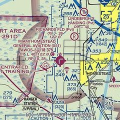
|
CAUTION: Diagram may not be current

| Airport distance calculator |
|---|
|
|
| Sunrise and sunset |
|---|
|
Times for 29-Jul-2026
| | Local
(UTC-4) | | Zulu
(UTC) |
|---|
| Morning civil twilight | | 06:24 | | 10:24 |
| Sunrise | | 06:48 | | 10:48 |
| Sunset | | 20:09 | | 00:09 |
| Evening civil twilight | | 20:34 | | 00:34 |
|
| Current date and time |
|---|
| Zulu (UTC) | 30-Jul-2026 03:50:35 |
|---|
| Local (UTC-4) | 29-Jul-2026 23:50:35 |
|---|
|
| METAR |
|---|
KHST
10nm E | 300255Z AUTO 22004KT 10SM CLR 28/24 A2999 RMK AO2 SLP159 T02750237 52017 $
|
KTMB
11nm NE | 300253Z AUTO 21005KT 10SM CLR 28/23 A3000 RMK AO2 SLP156 T02780228 53017 $
|
|
| TAF |
|---|
KHST
10nm E | 291900Z 2919/3101 23012G18KT 9999 FEW032 SCT050 BKN250 QNH2994INS BECMG 2923/2924 23006KT 9999 FEW025 QNH2995INS BECMG 3014/3015 21010G15KT 9999 SCT035 QNH2998INS BECMG 3023/3024 24006KT 9999 FEW027 QNH3001INS TX35/2919Z TN26/3011Z
|
KTMB
11nm NE | 292104Z 2921/3018 24011G21KT P6SM SCT030 SCT050 BKN250 FM300000 21007KT P6SM FEW030 SCT050 BKN250 FM300200 VRB04KT P6SM FEW050 SCT250 FM301700 23009KT P6SM SCT030 SCT050
|
|
| NOTAMs |
|---|
NOTAMs are issued by the DoD/FAA and will open in a separate window not controlled by AirNav.
|
|


