FAA INFORMATION EFFECTIVE 09 JULY 2026
Location
| FAA Identifier: | 08R |
| Lat/Long: | 41-29-22.2000N 071-37-14.3000W
41-29.370000N 071-37.238333W
41.4895000,-71.6206389
(estimated) |
| Elevation: | 130.4 ft. / 40 m (estimated) |
| Variation: | 15W (1985) |
| From city: | 3 miles W of WEST KINGSTON, RI |
| Time zone: | UTC -4 (UTC -5 during Standard Time) |
| Zip code: | 02892 |
Airport Operations
| Airport use: | Open to the public |
| Activation date: | 06/1955 |
| Control tower: | no |
| ARTCC: | BOSTON CENTER |
| FSS: | BRIDGEPORT FLIGHT SERVICE STATION |
| NOTAMs facility: | BDR (NOTAM-D service available) |
| Attendance: | 0900-1700 |
| Wind indicator: | lighted |
| Segmented circle: | no |
| Lights: | ACTVT LIRL RWY 11/29; WINDSOCK LGTS - CTAF. |
| Beacon: | ROTG BCN OTS INDEFLY. |
Airport Communications
| CTAF/UNICOM: | 122.8 |
| WX AWOS-3PT at OQU (11 nm NE): | PHONE 401-294-2197 |
| WX ASOS at WST (12 nm SW): | 132.375 (401-596-9543) |
| WX ASOS at UUU (15 nm E): | 132.075 (401-846-5910) |
| WX ASOS at PVD (16 nm NE): | 124.2 (401-734-2818) |
| WX AWOS-3PT at BID (19 nm S): | 134.775 (401-466-5495) |
Nearby radio navigation aids
| VOR radial/distance | | VOR name | | Freq | | Var |
|---|
| PVDr225/16.5 | | PROVIDENCE VOR/DME | | 115.60 | | 14W |
| ORWr117/17.5 | | NORWICH VOR/DME | | 110.00 | | 14W |
| SEYr009/19.4 | | SANDY POINT VOR/DME | | 117.80 | | 15W |
| GONr078/21.6 | | GROTON VOR/DME | | 110.85 | | 14W |
| PUTr174/29.7 | | PUTNAM VOR/DME | | 117.40 | | 14W |
Airport Services
| Fuel available: | 100LL |
| Parking: | hangars and tiedowns |
| Airframe service: | MAJOR |
| Powerplant service: | MAJOR |
Runway Information
Runway 11/29
| Dimensions: | 2129 x 30 ft. / 649 x 9 m |
| Surface: | asphalt, in excellent condition |
| Runway edge lights: | non-standard
NSTD LIRL LCTD 30 FT FM EDGE OF PAVEMENT. |
| Runway edge markings: | DSPLCD THR LGTD & MKD WITH WHITE BAR & NR. |
| RUNWAY 11 | | RUNWAY 29 |
| Latitude: | 41-29.394915N | | 41-29.345610N |
| Longitude: | 071-37.469095W | | 071-37.007455W |
| Elevation: | 130.4 ft. | | 127.1 ft. |
| Traffic pattern: | left | | left |
| Runway heading: | 113 magnetic, 098 true | | 293 magnetic, 278 true |
| Displaced threshold: | no | | 130 ft. |
| Markings: | numbers only, in good condition | | numbers only, in good condition |
| Visual slope indicator: | | | tri-color VASI on left (5.50 degrees glide path) |
| Touchdown point: | yes, no lights | | yes, no lights |
| Obstructions: | 45 ft. trees, 600 ft. from runway, 45 ft. right of centerline, 8:1 slope to clear
RWY 11, +23 FT TREES 150 FT FM THLD, 50 FT LEFT; +27 FT TREES 160 FT FM THLD, 110 FT RIGHT. | | 65 ft. tree, 200 ft. from runway, 45 ft. right of centerline
RWY 29, 11 FT WIDE ROAD 90 FT FM THLD, ON CNTRLN; +40 FT TREES 125 FT FM THLD, 110 FT LEFT; +65 FT TREES 200 FT FM THLD, 45 FT RIGHT. |
Airport Ownership and Management from official FAA records
| Ownership: | Privately-owned |
| Owner: | GORDON REALTY, INC
23 HEATON ORCHARD RD
WEST KINGSTON, RI 02892
Phone 401-783-1498 |
| Manager: | JACK GORDON
23 HEATON ORCHARD RD
WEST KINGSTON, RI 02892
Phone 401-783-1498 |
Additional Remarks
| - | ULTRALIGHTS ON & INVOF ARPT. |
| - | DEER & BIRDS ON & INVOF ARPT. |
| - | RWY 11 CLSD NGTS. |
| - | +40 FT DROPOFF, 150 FT FM RWY 29 END; +10 FT DROPOFF, 200 FT FM RWY 11 END. |
| - | IREG HRS OF OPN. CALL 401 783-1498 FOR ACFT RQRG FUEL. |
| - | FOR CD CTC PROVIDENCE APCH AT 401-738-8945, WHEN APCH CLSD CTC BOSTON ARTCC AT 603-879-6859. |
| - | RWY HAS NON-STD SAFETY AREA, CTC AMGR FOR DTLS. |
Instrument Procedures
There are no published instrument procedures at 08R.
Some nearby airports with instrument procedures:
KOQU - Quonset State Airport (11 nm NE)
KWST - Westerly State Airport (12 nm SW)
KUUU - Newport State Airport (15 nm E)
KPVD - Rhode Island TF Green International Airport (16 nm NE)
KBID - Block Island State Airport (19 nm S)
|
|

Road maps at:
MapQuest
Bing
Google
| Aerial photo |
|---|
WARNING: Photo may not be current or correct

Do you have a better or more recent aerial photo of Richmond Airport that you would like to share? If so, please send us your photo.
|
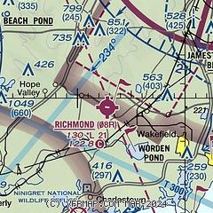
| Sectional chart |
|---|
|
| Airport distance calculator |
|---|
|
|
| Sunrise and sunset |
|---|
|
Times for 19-Jul-2026
| | Local
(UTC-4) | | Zulu
(UTC) |
|---|
| Morning civil twilight | | 04:57 | | 08:57 |
| Sunrise | | 05:30 | | 09:30 |
| Sunset | | 20:15 | | 00:15 |
| Evening civil twilight | | 20:48 | | 00:48 |
|
| Current date and time |
|---|
| Zulu (UTC) | 19-Jul-2026 21:00:41 |
|---|
| Local (UTC-4) | 19-Jul-2026 17:00:41 |
|---|
|
| METAR |
|---|
KOQU
11nm NE | 191950Z 32012G18KT 10SM FEW040 27/11 A2977
|
KWST
12nm SW | 192053Z AUTO VRB03KT 10SM CLR 26/12 A2980 RMK AO2 SLP090 T02610117 50004
|
KUUU
15nm E | 192053Z AUTO 31009KT 10SM CLR 26/12 A2979 RMK AO2 SLP085 T02560117 51006 TSNO
|
KPVD
16nm NE | 192051Z 29011G20KT 10SM FEW065 26/09 A2979 RMK AO2 SLP087 T02610094 50007 $
|
KBID
20nm S | 191956Z AUTO 27008KT 10SM CLR 24/14 A2981 RMK AO2 SLP094 T02440144 PNO $
|
KGON
21nm SW | 191956Z 30010KT 10SM FEW060 26/12 A2980 RMK AO2 SLP090 T02560122
|
|
| TAF |
|---|
KPVD
16nm NE | 191720Z 1918/2018 33013G21KT P6SM SKC FM192300 32007KT P6SM SKC
|
|
| NOTAMs |
|---|
NOTAMs are issued by the DoD/FAA and will open in a separate window not controlled by AirNav.
|
|

