FAA INFORMATION EFFECTIVE 20 MARCH 2025
Location
| FAA Identifier: | 0B7 |
| Lat/Long: | 44-07-02.6000N 072-49-37.2000W
44-07.043333N 072-49.620000W
44.1173889,-72.8270000
(estimated) |
| Elevation: | 1470 ft. / 448 m (estimated) |
| Variation: | 16W (1985) |
| From city: | 2 miles E of WARREN, VT |
| Time zone: | UTC -4 (UTC -5 during Standard Time) |
| Zip code: | 05674 |
Airport Operations
| Airport use: | Open to the public |
| Activation date: | 08/1966 |
| Control tower: | no |
| ARTCC: | BOSTON CENTER |
| FSS: | BURLINGTON FLIGHT SERVICE STATION |
| NOTAMs facility: | BTV (NOTAM-D service available) |
| Attendance: | MAY-OCT 0900-1800 |
| Wind indicator: | yes |
| Segmented circle: | yes
SEGMENTED CIRCLE NSTD. |
Airport Communications
| CTAF/UNICOM: | 123.0 |
| WX ASOS at MPV (13 nm NE): | 132.675 (802-229-2037) |
| WX AWOS-3 at 6B0 (14 nm SW): | 118.575 (802-388-0255) |
Nearby radio navigation aids
| VOR radial/distance | | VOR name | | Freq | | Var |
|---|
| MPVr293/16.4 | | MONTPELIER VOR/DME | | 116.90 | | 16W |
| BTVr153/22.7 | | BURLINGTON VOR/DME | | 117.50 | | 15W |
| NDB name | | Hdg/Dist | | Freq | | Var | | ID |
|---|
| SMUTO | | 028/25.3 | | 221 | | 15W | | DYO | -.. -.-- --- |
| HANOVER | | 327/37.5 | | 276 | | 15W | | LAH | .-.. .- .... |
Airport Services
| Fuel available: | 100LL
100LL:SELF SERVE ONLY DURING HOURS AIRPORT IS OPEN |
| Parking: | tiedowns |
Runway Information
Runway 4/22
| Dimensions: | 2575 x 30 ft. / 785 x 9 m |
| Surface: | asphalt, in excellent condition |
| Weight bearing capacity: | |
| RUNWAY 4 | | RUNWAY 22 |
| Latitude: | 44-06.861855N | | 44-07.225130N |
| Longitude: | 072-49.770925W | | 072-49.467638W |
| Elevation: | 1452.0 ft. | | 1440.0 ft. |
| Traffic pattern: | right | | left |
| Runway heading: | 047 magnetic, 031 true | | 227 magnetic, 211 true |
| Markings: | basic, in good condition | | basic, in good condition |
| Runway end identifier lights: | no | | no |
| Obstructions: | 50 ft. trees, 213 ft. from runway, 50 ft. right of centerline, 1:1 slope to clear
RW04 HAS 50 FOOT TREES 50 FEET RIGHT AND LEFT, 200 FEET FROM RW END | | 49 ft. trees, 395 ft. from runway, 122 ft. left of centerline, 3:1 slope to clear
RWY 22 +56 FT TREES 198 FT FROM THE RWY END AND 119 FT LEFT |
Airport Ownership and Management from official FAA records
| Ownership: | Privately-owned |
| Owner: | GRANITE INTERSECTION INC
BOX ONE
WAITSFIELD, VT 05673
Phone 802-496-2290 |
| Manager: | TOM ANDERSON
PO BOX 123
WARREN, VT 05674
Phone 802-496-2290 |
Additional Remarks
| - | EXTENSIVE GLIDER ACTIVITY ON ARPT SFC TO 18000 FT DALGT HOURS. |
| - | ARPT CLSD NOV-APR. |
| - | NO LINE OF SIGHT BTN RY ENDS. |
| - | TOUCH & GO LDGS NOT PERMITTED. |
| - | OCCASIONAL AEROBATIC ACTIVITY; ARPT MAY BE CLSD DURG THIS ACTIVITY; CHECK NOTAMS. |
| - | GRASS AREAS NOT AUTHORIZED FOR TAXI, TAKEOFFS & LDGS WITHOUT FIRST CHECKING UNICOM OR MANAGEMENT FOR FIELD CONDS. |
| - | FOR CD CTC BURLINGTON APCH AT 802-657-4413, WHEN APCH CLSD CTC BOSTON ARTCC AT 603-879-6859. |
Instrument Procedures
There are no published instrument procedures at 0B7.
Some nearby airports with instrument procedures:
KMPV - Edward F Knapp State Airport (13 nm NE)
KBTV - Patrick Leahy Burlington International Airport (25 nm NW)
KMVL - Morrisville-Stowe State Airport (27 nm N)
4B6 - Ticonderoga Municipal Airport (29 nm SW)
5B9 - Dean Memorial Airport (35 nm E)
|
|

Road maps at:
MapQuest
Bing
Google
| Aerial photo |
|---|
WARNING: Photo may not be current or correct
 Photo by Carl Johnson
Taken in the Summer of 2017
looking southwest.
Do you have a better or more recent aerial photo of Warren-Sugarbush Airport that you would like to share? If so, please send us your photo.
|
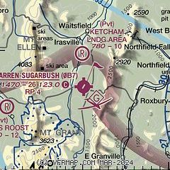
| Sectional chart |
|---|

|
| Airport distance calculator |
|---|
|
|
| Sunrise and sunset |
|---|
|
Times for 07-Apr-2025
| | Local
(UTC-4) | | Zulu
(UTC) |
|---|
| Morning civil twilight | | 05:53 | | 09:53 |
| Sunrise | | 06:23 | | 10:23 |
| Sunset | | 19:24 | | 23:24 |
| Evening civil twilight | | 19:54 | | 23:54 |
|
| Current date and time |
|---|
| Zulu (UTC) | 08-Apr-2025 03:46:15 |
|---|
| Local (UTC-4) | 07-Apr-2025 23:46:15 |
|---|
|
| METAR |
|---|
KMPV
12nm NE | 080251Z AUTO 18006KT 8SM SCT017 OVC036 01/M01 A2967 RMK AO2 RAB15E24UPB24E34 SLP059 P0000 60000 T00111011 58013
|
K6B0
14nm SW | 080335Z AUTO 00000KT 10SM OVC029 03/00 A2962 RMK AO2 T00271003
|
|
| TAF |
|---|
KMPV
12nm NE | 071720Z 0718/0818 VRB04KT P6SM SCT060 BKN200 FM072200 16007KT P6SM BKN035 FM080300 16006KT P6SM BKN025 FM080600 16007KT P6SM OVC012 PROB30 0808/0811 2SM -SHSN BR FM081100 17008G20KT 2SM -SHSN BR OVC015 FM081400 24010KT P6SM BKN035
|
|
| NOTAMs |
|---|
NOTAMs are issued by the DoD/FAA and will open in a separate window not controlled by AirNav.
|
|


