FAA INFORMATION EFFECTIVE 19 FEBRUARY 2026
Location
| FAA Identifier: | 0S7 |
| Lat/Long: | 48-57-32.3000N 119-24-43.1000W
48-57.538333N 119-24.718333W
48.9589722,-119.4119722
(estimated) |
| Elevation: | 1069 ft. / 325.8 m (surveyed) |
| Variation: | 21E (1985) |
| From city: | 2 miles NE of OROVILLE, WA |
| Time zone: | UTC -8 (UTC -7 during Daylight Saving Time) |
| Zip code: | 98844 |
Airport Operations
| Airport use: | Open to the public |
| Activation date: | 08/1937 |
| Control tower: | no |
| ARTCC: | SEATTLE CENTER |
| FSS: | SEATTLE FLIGHT SERVICE STATION |
| NOTAMs facility: | SEA (NOTAM-D service available) |
| Attendance: | DAWN - DUSK
ON CALL FOR SERVICE ALTERNATE NUMBER, 509-322-2887 |
| Wind indicator: | lighted |
| Segmented circle: | yes |
| Lights: | ACTVT MIRL RWY 15/33 - CTAF. |
| Beacon: | white-green (lighted land airport)
ARPT ROTG BCN LCTD 1500 FT EAST OF CNTRLN OF ARPT ON TOP OF HILL APRX 900 FT ABOVE ARPT ELEV. Operates sunset to sunrise. |
| International operations: | international airport of entry |
Airport Communications
Airport Services
| Fuel available: | 100LL |
| Parking: | tiedowns |
| Airframe service: | MAJOR |
| Powerplant service: | MAJOR |
| Bottled oxygen: | NONE |
| Bulk oxygen: | NONE |
Runway Information
Runway 15/33
| Dimensions: | 4017 x 50 ft. / 1224 x 15 m |
| Surface: | asphalt, in fair condition
RWY 15/33 CRACKS IN TWY PAVEMENT. |
| Weight bearing capacity: | |
| Runway edge lights: | medium intensity |
| Runway edge markings: | FADED. |
| RUNWAY 15 | | RUNWAY 33 |
| Latitude: | 48-57.858900N | | 48-57.216805N |
| Longitude: | 119-24.835203W | | 119-24.600128W |
| Elevation: | 1068.5 ft. | | 1062.6 ft. |
| Traffic pattern: | right | | left |
| Runway heading: | 145 magnetic, 166 true | | 325 magnetic, 346 true |
| Markings: | basic, in poor condition | | basic, in poor condition |
| Touchdown point: | yes, no lights | | yes, no lights |
| Obstructions: | 18 ft. bldg, 850 ft. from runway, 130 ft. right of centerline, 36:1 slope to clear | | 13 ft. trees, 474 ft. from runway, 21:1 slope to clear |
Airport Ownership and Management from official FAA records
| Ownership: | Publicly-owned |
| Owner: | CITY OF OROVILLE
PO BOX 2200
OROVILLE, WA 98844
Phone 509-476-2926 |
| Manager: | STEVE THOMPSON
PO BOX 1002
OROVILLE, WA 98844
Phone 509-476-2345 |
Additional Remarks
| - | CUSTOMS TELEPHONE 509-476-2955. |
| - | BRUSH, ROADS & TIE DOWNS IN PRIMARY SFC. |
| - | FLIGHT NOTIFICTION SERVICE (ADCUS) AVBL. |
| - | WILDLIFE ADJ TO RY/TWY. |
| - | FOR CD CTC SEATTLE ARTCC AT 253-351-3694. |
Instrument Procedures
There are no published instrument procedures at 0S7.
Some nearby airports with instrument procedures:
KOMK - Omak Airport (30 nm S)
3W7 - Grand Coulee Dam Airport (64 nm S)
2S8 - Wilbur Airport (77 nm S)
KDEW - Deer Park Airport (99 nm SE)
KEAT - Pangborn Memorial Airport (99 nm S)
|
|

Road maps at:
MapQuest
Bing
Google
| Aerial photo |
|---|
WARNING: Photo may not be current or correct
 Photo taken 25-Apr-2018
looking northeast.
Photo taken 25-Apr-2018
looking northeast.
Do you have a better or more recent aerial photo of Dorothy Scott International Airport that you would like to share? If so, please send us your photo.
|
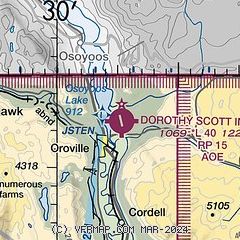
| Sectional chart |
|---|
|
| Airport distance calculator |
|---|
|
|
| Sunrise and sunset |
|---|
|
Times for 14-Mar-2026
| | Local
(UTC-7) | | Zulu
(UTC) |
|---|
| Morning civil twilight | | 06:42 | | 13:42 |
| Sunrise | | 07:14 | | 14:14 |
| Sunset | | 19:00 | | 02:00 |
| Evening civil twilight | | 19:31 | | 02:31 |
|
| Current date and time |
|---|
| Zulu (UTC) | 14-Mar-2026 23:49:46 |
|---|
| Local (UTC-7) | 14-Mar-2026 16:49:46 |
|---|
|
| METAR |
|---|
CWYY
3nm N | 142300Z AUTO 32007KT 07/M11 RMK AO1 PK WND 34017/2208 SLP238 T00711106 53020
|
|
| TAF |
|---|
CYYF
31nm N | 141840Z 1419/1507 35015G25KT P6SM FEW050 SCT100 BECMG 1501/1503 VRB03KT RMK NXT FCST BY 150100Z
|
|
| NOTAMs |
|---|
NOTAMs are issued by the DoD/FAA and will open in a separate window not controlled by AirNav.
|
|

