FAA INFORMATION EFFECTIVE 30 OCTOBER 2025
Location
| FAA Identifier: | 15G |
| Lat/Long: | 41-01-41.4650N 081-47-53.3300W
41-01.691083N 081-47.888833W
41.0281847,-81.7981472
(estimated) |
| Elevation: | 1210 ft. / 369 m (estimated) |
| Variation: | 06W (1985) |
| From city: | 3 miles W of WADSWORTH, OH |
| Time zone: | UTC -5 (UTC -4 during Daylight Saving Time) |
| Zip code: | 44281 |
Airport Operations
| Airport use: | Open to the public |
| Activation date: | 07/1967 |
| Control tower: | no |
| ARTCC: | CLEVELAND CENTER |
| FSS: | CLEVELAND FLIGHT SERVICE STATION |
| NOTAMs facility: | CLE (NOTAM-D service available) |
| Attendance: | DAWN TO DUSK |
| Pattern altitude: | 2000 ft. MSL |
| Wind indicator: | lighted |
| Segmented circle: | no |
| Lights: | ACTVT NSTD LIRL RWY 03/21 - CTAF. |
| Beacon: | white-green (lighted land airport)
Operates sunset to sunrise. |
Airport Communications
| CTAF/UNICOM: | 123.05 |
| WX ASOS at BJJ (10 nm SW): | 118.075 (330-669-9105) |
| WX ASOS at AKR (15 nm E): | 126.825 (330-724-4237) |
| WX ASOS at CAK (17 nm SE): | PHONE 330-227-8682 |
| WX AWOS-2 at 1G3 (19 nm NE): | 119.15 (330-346-1497) |
Nearby radio navigation aids
| VOR radial/distance | | VOR name | | Freq | | Var |
|---|
| BSVr320/23.9 | | BRIGGS VOR/DME | | 114.05 | | 04W |
| DJBr145/25.7 | | DRYER VOR/DME | | 113.60 | | 05W |
| ACOr264/27.4 | | AKRON VOR/DME | | 114.40 | | 04W |
Airport Services
| Fuel available: | 100LL |
| Parking: | hangars and tiedowns |
| Airframe service: | MAJOR |
| Powerplant service: | MAJOR |
| Bottled oxygen: | NONE |
| Bulk oxygen: | NONE |
Runway Information
Runway 3/21
| Dimensions: | 2410 x 37 ft. / 735 x 11 m |
| Surface: | asphalt, in fair condition |
| Weight bearing capacity: | | Single wheel: | LTD TO 6500 LBS PER AMGR. |
|
| Runway edge lights: | non-standard
NSTD LIRL DUE TO INCOR COLORS & MOUNTING ON 6 IN PVC PIPE. |
| RUNWAY 3 | | RUNWAY 21 |
| Latitude: | 41-01.510667N | | 41-01.871500N |
| Longitude: | 081-47.997833W | | 081-47.779833W |
| Elevation: | 1210.0 ft. | | 1210.0 ft. |
| Traffic pattern: | left | | left |
| Runway heading: | 031 magnetic, 025 true | | 211 magnetic, 205 true |
| Displaced threshold: | 178 ft. | | 50 ft. |
| Markings: | basic, in fair condition | | basic, in fair condition |
| Visual slope indicator: | pulsating/steady burning VASI on left | | pulsating/steady burning VASI on left |
| Runway end identifier lights: | no | | no |
| Obstructions: | 8 ft. crops, 201 ft. from runway, 85 ft. right of centerline
15 FT ROAD, 0 FT DIST, 55 FT R; +8 FT SIGN, 85 FT L; 25 FT PLINE, 105 FT L/R. | | 55 ft. trees, 385 ft. from runway, 145 ft. both sides of centerline, 3:1 slope to clear
10-15 FT BRUSH & TREES, 0 FT DIST FM RWY END; 25-30 FT TREES, L/R; 1 FT GUARD RAIL, ACRS RWY END. |
Airport Ownership and Management from official FAA records
| Ownership: | Privately-owned |
| Owner: | SKYPARK INC
3071 GREENWICH RD
WADSWORTH, OH 44281-9516
Phone 330-573-6437
WELTZIENSKYPARK@GMAIL.COM. |
| Manager: | JOEL KULL
3071 GREENWICH RD
WADSWORTH, OH 44281-9516
Phone 330-573-6437 |
Additional Remarks
| - | TGL PROHIBITED. |
| - | OCNL BIRDS & WILDLIFE ON & INVOF ARPT. |
| - | FOR CD CTC CLEVELAND APCH AT 216-352-2323. |
Instrument Procedures
There are no published instrument procedures at 15G.
Some nearby airports with instrument procedures:
3G3 - Wadsworth Municipal Airport (2 nm SE)
1G5 - Medina Municipal Airport (6 nm N)
KBJJ - Wayne County Airport (10 nm SW)
KAKR - Akron Fulton International Airport (15 nm E)
KCAK - Akron-Canton Regional Airport (17 nm SE)
1G3 - Kent State University Airport (19 nm NE)
|
|

Road maps at:
MapQuest
Bing
Google
| Aerial photo |
|---|
WARNING: Photo may not be current or correct

Do you have a better or more recent aerial photo of Weltzien Skypark Airport that you would like to share? If so, please send us your photo.
|
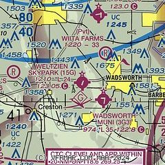
| Sectional chart |
|---|
|
| Airport distance calculator |
|---|
|
|
| Sunrise and sunset |
|---|
|
Times for 06-Nov-2025
| | Local
(UTC-5) | | Zulu
(UTC) |
|---|
| Morning civil twilight | | 06:36 | | 11:36 |
| Sunrise | | 07:05 | | 12:05 |
| Sunset | | 17:17 | | 22:17 |
| Evening civil twilight | | 17:46 | | 22:46 |
|
| Current date and time |
|---|
| Zulu (UTC) | 06-Nov-2025 17:02:47 |
|---|
| Local (UTC-5) | 06-Nov-2025 12:02:47 |
|---|
|
| METAR |
|---|
KBJJ
10nm S | 061656Z AUTO 10SM CLR 10/M02 A3025 RMK AO2 SLP248 T01001022 PWINO $
|
KAKR
15nm E | 061654Z AUTO VRB04KT 10SM FEW046 10/M02 A3023 RMK AO2 SLP240 T01001017 PWINO $
|
KCAK
17nm SE | 061651Z 30008KT 10SM SCT040 09/M01 A3023 RMK AO2 SLP242 T00941006 $
|
|
| TAF |
|---|
KCAK
17nm SE | 061138Z 0612/0712 27005KT P6SM SKC FM070000 16005KT P6SM SKC FM071000 17012KT P6SM OVC250 WS020/20040KT
|
|
| NOTAMs |
|---|
NOTAMs are issued by the DoD/FAA and will open in a separate window not controlled by AirNav.
|
|


