FAA INFORMATION EFFECTIVE 26 DECEMBER 2024
Location
| FAA Identifier: | 1D6 |
| Lat/Long: | 44-43-51.9691N 094-42-49.6296W
44-43.866152N 094-42.827160W
44.7311025,-94.7137860
(estimated) |
| Elevation: | 1078 ft. / 329 m (estimated) |
| Variation: | 04E (1985) |
| From city: | 1 mile S of HECTOR, MN |
| Time zone: | UTC -6 (UTC -5 during Daylight Saving Time) |
| Zip code: | 55342 |
Airport Operations
| Airport use: | Open to the public |
| Activation date: | 03/1942 |
| Control tower: | no |
| ARTCC: | MINNEAPOLIS CENTER |
| FSS: | PRINCETON FLIGHT SERVICE STATION |
| NOTAMs facility: | PNM (NOTAM-D service available) |
| Attendance: | UNATNDD
CALL 320-848-2745. |
| Wind indicator: | lighted |
| Segmented circle: | no |
| Lights: | SS-SR |
Airport Communications
| CTAF/UNICOM: | 122.8 |
| WX AWOS-3 at OVL (14 nm W): | 119.275 (320-523-5924) |
| WX AWOS-3 at HCD (16 nm NE): | 118.525 (320-587-3343) |
| WX ASOS at RWF (19 nm SW): | 126.575 (507-644-3564) |
Nearby radio navigation aids
| VOR radial/distance | | VOR name | | Freq | | Var |
|---|
| RWFr041/23.8 | | REDWOOD FALLS VOR/DME | | 113.30 | | 07E |
| BDHr139/29.1 | | WILLMAR VOR/DME | | 113.70 | | 04E |
Airport Services
| Fuel available: | 100LL
100LL:FUEL SVC CALL 320-848-2745. |
| Parking: | tiedowns |
| Airframe service: | NONE |
| Powerplant service: | NONE |
| Bottled oxygen: | NONE |
| Bulk oxygen: | NONE |
Runway Information
Runway 12/30
| Dimensions: | 2776 x 50 ft. / 846 x 15 m |
| Surface: | asphalt, in fair condition |
| Runway edge lights: | non-standard
LGTS MOUNTED IN YELLOW CONES. |
| RUNWAY 12 | | RUNWAY 30 |
| Latitude: | 44-44.006167N | | 44-43.738333N |
| Longitude: | 094-42.973333W | | 094-42.454500W |
| Elevation: | 1078.0 ft. | | 1077.0 ft. |
| Traffic pattern: | left | | left |
| Runway heading: | 122 magnetic, 126 true | | 302 magnetic, 306 true |
| Markings: | basic, in good condition | | basic, in good condition |
| Runway end identifier lights: | no | | no |
| Touchdown point: | yes, no lights | | yes, no lights |
| Obstructions: | 17 ft. road, 504 ft. from runway, 150 ft. right of centerline, 17:1 slope to clear | | none |
Runway 5/23
| Dimensions: | 2395 x 185 ft. / 730 x 56 m |
| Surface: | turf, in good condition |
| Runway edge markings: | YELLOW CONES. |
| Operational restrictions: | NOT PLOWED WINTER MONTHS. |
| RUNWAY 5 | | RUNWAY 23 |
| Latitude: | 44-43.741333N | | 44-43.976833N |
| Longitude: | 094-43.180000W | | 094-42.736833W |
| Elevation: | 1077.1 ft. | | 1076.9 ft. |
| Traffic pattern: | left | | left |
| Runway heading: | 049 magnetic, 053 true | | 229 magnetic, 233 true |
| Runway end identifier lights: | no | | no |
| Touchdown point: | yes, no lights | | yes, no lights |
| Obstructions: | 19 ft. road, 397 ft. from runway, 20:1 slope to clear | | 5 ft. crops, 96 ft. from runway, 85 ft. left of centerline, 19:1 slope to clear |
Airport Ownership and Management from official FAA records
| Ownership: | Publicly-owned |
| Owner: | CITY OF HECTOR
301 MAIN ST N
HECTOR, MN 55342
Phone 320-848-2122 |
| Manager: | GINA SCHELLENBERG
78980 STATE HIGHWAY 4
HECTOR, MN 55342-1235
Phone 320-522-1966 |
Additional Remarks
| - | +8 FT CROPS IN PRI SFC OF ALL RWYS. |
| - | FOR CD CTC MINNEAPOLIS ARTCC AT 651-463-5588. |
Instrument Procedures
There are no published instrument procedures at 1D6.
Some nearby airports with instrument procedures:
KOVL - Olivia Regional Airport (14 nm W)
KHCD - Hutchinson Municipal Airport-Butler Field (16 nm NE)
KRWF - Redwood Falls Municipal Airport (19 nm SW)
KLJF - Litchfield Municipal Airport (24 nm N)
KULM - New Ulm Municipal Airport (26 nm S)
|
|

Road maps at:
MapQuest
Bing
Google
| Aerial photo |
|---|
WARNING: Photo may not be current or correct
 Photo by Gary Bipes
Photo taken 16-Sep-2007
Photo by Gary Bipes
Photo taken 16-Sep-2007
Do you have a better or more recent aerial photo of Hector Municipal Airport that you would like to share? If so, please send us your photo.
|
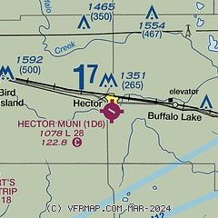
| Sectional chart |
|---|
|
| Airport distance calculator |
|---|
|
|
| Sunrise and sunset |
|---|
|
Times for 20-Jan-2025
| | Local
(UTC-6) | | Zulu
(UTC) |
|---|
| Morning civil twilight | | 07:18 | | 13:18 |
| Sunrise | | 07:51 | | 13:51 |
| Sunset | | 17:09 | | 23:09 |
| Evening civil twilight | | 17:42 | | 23:42 |
|
| Current date and time |
|---|
| Zulu (UTC) | 20-Jan-2025 12:34:31 |
|---|
| Local (UTC-6) | 20-Jan-2025 06:34:31 |
|---|
|
| METAR |
|---|
KOVL
14nm W | 201216Z AUTO 00000KT 10SM CLR M25/M28 A3043 RMK AO2
|
KHCD
17nm NE | 201215Z AUTO 30005KT 10SM CLR M24/M28 A3041 RMK AO2 T12401282
|
KRWF
19nm SW | 201153Z AUTO 30007KT 8SM FEW016 FEW038 M24/M28 A3043 RMK AO2 SLP337 T12441278 11228 21250 53005 $
|
KLJF
24nm N | 201208Z AUTO 30003KT 10SM CLR M26/M29 A3039 RMK AO2
|
KULM
26nm S | 201215Z AUTO 28006KT 10SM CLR M25/M29 A3042 RMK AO2
|
KGYL
27nm E | 201215Z AUTO 00000KT 10SM CLR M24/M28 A3041 RMK AO2 T12441277
|
|
| TAF |
|---|
KRWF
19nm SW | 201140Z 2012/2112 30008KT P6SM SCT020 BKN040 FM201500 31012G23KT P6SM SCT020 BKN040 FM202300 31011G20KT P6SM SCT040 FM210400 30008KT P6SM SKC FM211000 24006KT P6SM FEW250
|
|
| NOTAMs |
|---|
NOTAMs are issued by the DoD/FAA and will open in a separate window not controlled by AirNav.
|
|


