FAA INFORMATION EFFECTIVE 30 OCTOBER 2025
Location
| FAA Identifier: | 1D7 |
| Lat/Long: | 45-17-35.2000N 097-30-49.0000W
45-17.586667N 097-30.816667W
45.2931111,-97.5136111
(estimated) |
| Elevation: | 1857.6 ft. / 566.2 m (surveyed) |
| Variation: | 07E (1985) |
| From city: | 2 miles S of WEBSTER, SD |
| Time zone: | UTC -5 (UTC -6 during Standard Time) |
| Zip code: | 57274 |
Airport Operations
| Airport use: | Open to the public |
| Control tower: | no |
| ARTCC: | MINNEAPOLIS CENTER |
| FSS: | HURON FLIGHT SERVICE STATION |
| NOTAMs facility: | HON (NOTAM-D service available) |
| Attendance: | UNATNDD |
| Wind indicator: | lighted |
| Segmented circle: | yes |
| Lights: | ACTVT MIRL RWY 12/30; PAPI RWY 12 & 30 - CTAF. |
| Beacon: | white-green (lighted land airport)
Operates sunset to sunrise. |
Airport Communications
Nearby radio navigation aids
| VOR radial/distance | | VOR name | | Freq | | Var |
|---|
| ABRr095/36.8 | | ABERDEEN VOR/DME | | 113.00 | | 07E |
Airport Services
| Fuel available: | 100LL
100LL:FUEL AVBL 24 HRS WITH CREDIT CARD. |
| Oil available: | AUTOMATED UNICOM. ADZY ALSO AVBL BY CALLING 617-262-3825. |
| Parking: | tiedowns |
| Airframe service: | NONE |
| Powerplant service: | NONE |
| Bottled oxygen: | NONE |
| Bulk oxygen: | NONE |
Runway Information
Runway 12/30
| Dimensions: | 3705 x 60 ft. / 1129 x 18 m |
| Surface: | asphalt, in excellent condition |
| Weight bearing capacity: | |
| Runway edge lights: | medium intensity |
| RUNWAY 12 | | RUNWAY 30 |
| Latitude: | 45-17.737540N | | 45-17.405378N |
| Longitude: | 097-31.065800W | | 097-30.341558W |
| Elevation: | 1856.6 ft. | | 1845.1 ft. |
| Traffic pattern: | left | | left |
| Runway heading: | 116 magnetic, 123 true | | 296 magnetic, 303 true |
| Markings: | nonprecision, in good condition | | nonprecision, in good condition |
| Visual slope indicator: | 2-light PAPI on left (3.00 degrees glide path) | | 2-light PAPI on left (3.00 degrees glide path) |
| Runway end identifier lights: | no | | no |
| Touchdown point: | yes, no lights | | yes, no lights |
| Obstructions: | 19 ft. road, 600 ft. from runway, 21:1 slope to clear | | none |
Runway 1/19
| Dimensions: | 2221 x 125 ft. / 677 x 38 m |
| Surface: | turf, in good condition |
| Runway edge markings: | RWY 01/19 MKD WITH WHITE BLACK TIPPED MKR CONES. |
| Operational restrictions: | CLSD WINTER MONTHS. |
| RUNWAY 1 | | RUNWAY 19 |
| Latitude: | 45-17.432135N | | 45-17.796240N |
| Longitude: | 097-31.028780W | | 097-30.983732W |
| Elevation: | 1851.1 ft. | | 1857.6 ft. |
| Traffic pattern: | left | | left |
| Runway end identifier lights: | no | | no |
| Touchdown point: | yes, no lights | | yes, no lights |
| Obstructions: | 5 ft. fence, 100 ft. from runway, 20:1 slope to clear | | 22 ft. trees, 450 ft. from runway, 50 ft. right of centerline, 20:1 slope to clear |
Airport Ownership and Management from official FAA records
| Ownership: | Publicly-owned |
| Owner: | CITY OF WEBSTER
PO BOX 539
WEBSTER, SD 57274
Phone 605-345-3241
AFTER HOURS PHONE (605) 345-4040 |
| Manager: | CITY OF WEBSTER
PO BOX 539
WEBSTER, SD 57274
Phone 605-345-3241 |
Additional Remarks
| - | RY 19 +4' FENCE 306' FM THR; 17 ROAD 340' FM THR. |
| - | BIRDS AND WATERFOWL ON AND INVOF ARPT. |
| - | FOR CD CTC MINNEAPOLIS ARTCC AT 651-463-5588. |
Instrument Procedures
There are no published instrument procedures at 1D7.
Some nearby airports with instrument procedures:
8D7 - Clark County Airport (25 nm S)
KATY - Watertown Regional Airport (27 nm SE)
8D3 - Sisseton Municipal Airport (31 nm NE)
KBTN - Britton Municipal Airport (33 nm N)
KABR - Aberdeen Regional Airport (39 nm W)
|
|

Road maps at:
MapQuest
Bing
Google
| Aerial photo |
|---|
WARNING: Photo may not be current or correct
 Photo courtesy of Al Machmiller
Do you have a better or more recent aerial photo of The Sigurd Anderson Airport that you would like to share? If so, please send us your photo.
|
| Sectional chart |
|---|
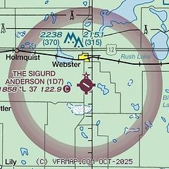
|
| Airport distance calculator |
|---|
|
|
| Sunrise and sunset |
|---|
|
Times for 31-Oct-2025
| | Local
(UTC-5) | | Zulu
(UTC) |
|---|
| Morning civil twilight | | 07:38 | | 12:38 |
| Sunrise | | 08:09 | | 13:09 |
| Sunset | | 18:19 | | 23:19 |
| Evening civil twilight | | 18:49 | | 23:49 |
|
| Current date and time |
|---|
| Zulu (UTC) | 01-Nov-2025 01:55:26 |
|---|
| Local (UTC-5) | 31-Oct-2025 20:55:26 |
|---|
|
| TAF |
|---|
KATY
28nm SE | 010027Z 0100/0124 34011G20KT P6SM -SHRA OVC014 TEMPO 0100/0102 5SM -SHRA BKN035 FM010200 34012G21KT P6SM -SHRA OVC008 FM010800 35009KT P6SM BKN020 FM011500 34006KT P6SM BKN035 FM011900 30004KT P6SM BKN050
|
|
| NOTAMs |
|---|
NOTAMs are issued by the DoD/FAA and will open in a separate window not controlled by AirNav.
|
|

