FAA INFORMATION EFFECTIVE 27 NOVEMBER 2025
Location
| FAA Identifier: | ABR |
| Lat/Long: | 45-26-48.4730N 098-25-20.7870W
45-26.807883N 098-25.346450W
45.4467981,-98.4224408
(estimated) |
| Elevation: | 1301.9 ft. / 396.8 m (surveyed) |
| Variation: | 07E (2000) |
| From city: | 2 miles E of ABERDEEN, SD |
| Time zone: | UTC -6 (UTC -5 during Daylight Saving Time) |
| Zip code: | 57401 |
Airport Operations
| Airport use: | Open to the public |
| Activation date: | 12/1937 |
| Control tower: | no |
| ARTCC: | MINNEAPOLIS CENTER |
| FSS: | HURON FLIGHT SERVICE STATION |
| NOTAMs facility: | ABR (NOTAM-D service available) |
| Attendance: | MON-FRI 0330-2400L
FOR SVCS AFTER HRS CALL (605) 225-1384/8008 OR (605)725-4774 |
| Wind indicator: | lighted |
| Segmented circle: | yes |
| Lights: | ACTVT MALSR RWY 31; REIL RWYS 13, 17, & 35; & PAPI RWY 13/31,17/35 - CTAF; MIRL RWY 17/35 & HIRL RWY 13/31 PRESET ON LOW INTST SS-2400; TO INCR INTST USE CTAF. |
| Beacon: | white-green (lighted land airport)
Operates sunset to sunrise. |
| Fire and rescue: | ARFF index A |
| Airline operations: | PPR FOR UNSKED ACR OPNS WITH MORE THAN 30 PSGR SEATS CALL AMGR 605-626-7020. AFT HRS CALL 605-216-0321. |
Airport Communications
| CTAF/UNICOM: | 122.7 |
| WX ASOS: | 125.875 (605-206-9423) |
- APCH/DEP SVC PRVDD BY MINNEAPOLIS ARTCC ON FREQS 120.6/371.9 (ABERDEEN RCAG).
Nearby radio navigation aids
| VOR radial/distance | | VOR name | | Freq | | Var |
|---|
| ABRr301/2.9 | | ABERDEEN VOR/DME | | 113.00 | | 07E |
| NDB name | | Hdg/Dist | | Freq | | Var | | ID |
|---|
| RENEY | | 306/5.4 | | 203 | | 07E | | AB | .- -... |
Airport Services
| Fuel available: | 100LL JET-A |
| Parking: | hangars |
| Airframe service: | MAJOR |
| Powerplant service: | MAJOR |
| Bulk oxygen: | HIGH |
Runway Information
Runway 13/31
| Dimensions: | 6901 x 100 ft. / 2103 x 30 m |
| Surface: | concrete/grooved, in good condition |
| Weight bearing capacity: | | Single wheel: | 120.0 | | Double wheel: | 195.0 | | Double tandem: | 339.0 |
|
| Runway edge lights: | high intensity |
| RUNWAY 13 | | RUNWAY 31 |
| Latitude: | 45-27.314153N | | 45-26.510447N |
| Longitude: | 098-25.682240W | | 098-24.542750W |
| Elevation: | 1301.9 ft. | | 1300.9 ft. |
| Traffic pattern: | left | | left |
| Runway heading: | 128 magnetic, 135 true | | 308 magnetic, 315 true |
| Declared distances: | TORA:6901 TODA:6901 ASDA:6901 LDA:6901 | | TORA:6901 TODA:6901 ASDA:6901 LDA:6901 |
| Markings: | precision, in good condition | | precision, in good condition |
| Visual slope indicator: | 4-light PAPI on left (3.00 degrees glide path) | | 4-light PAPI on left (3.00 degrees glide path) |
| Approach lights: | | | MALSR: 1,400 foot medium intensity approach lighting system with runway alignment indicator lights |
| Runway end identifier lights: | yes | | |
| Touchdown point: | yes, no lights | | yes, no lights |
| Instrument approach: | | | ILS/DME |
Runway 17/35
| Dimensions: | 5500 x 100 ft. / 1676 x 30 m |
| Surface: | asphalt/grooved, in excellent condition |
| Weight bearing capacity: | | Single wheel: | 63.0 | | Double wheel: | 82.0 | | Double tandem: | 139.0 |
|
| Runway edge lights: | medium intensity |
| RUNWAY 17 | | RUNWAY 35 |
| Latitude: | 45-27.129372N | | 45-26.224315N |
| Longitude: | 098-25.640685W | | 098-25.639377W |
| Elevation: | 1301.8 ft. | | 1300.3 ft. |
| Traffic pattern: | left | | left |
| Runway heading: | 173 magnetic, 180 true | | 353 magnetic, 360 true |
| Declared distances: | TORA:5500 TODA:5500 ASDA:5500 LDA:5500 | | TORA:5500 TODA:5500 ASDA:5500 LDA:5500 |
| Markings: | precision, in good condition | | precision, in good condition |
| Visual slope indicator: | 4-light PAPI on right (3.00 degrees glide path) | | 4-light PAPI on left (3.00 degrees glide path) |
| Runway end identifier lights: | yes | | yes |
| Touchdown point: | yes, no lights | | yes, no lights |
Airport Ownership and Management from official FAA records
| Ownership: | Publicly-owned |
| Owner: | CITY OF ABERDEEN
123 S LINCOLN ST
ABERDEEN, SD 57401-1420
Phone 605-626-7020 |
| Manager: | RICH KROKEL
4740 6TH AVENUE SE
ABERDEEN, SD 57401-4215
Phone 605-626-7020 |
Additional Remarks
| A39-13/31 | PCR VALUE: 476/R/D/W/T |
| A39-17/35 | PCR VALUE: 250/F/D/X/T |
| - | BIRDS ON & INVOF ARPT. |
| - | ARPT NOT AVBL FOR INTL ARRIVALS. |
| - | SURFACE CONDITIONS NOT MONITORED 0000-0330L |
| - | FOR CD IF UNA TO CTC ON FSS FREQ, CTC MINNEAPOLIS ARTCC AT 651-463-5588. |
Instrument Procedures
NOTE: All procedures below are presented as PDF files. If you need a reader for these files, you should download the free Adobe Reader.NOT FOR NAVIGATION. Please procure official charts for flight.
FAA instrument procedures published for use from 27 November 2025 at 0901Z to 25 December 2025 at 0900Z.
IAPs - Instrument Approach Procedures |
|---|
| ILS OR LOC RWY 31 **CHANGED** | |
download (245KB) |
| RNAV (GPS) RWY 13 **CHANGED** | |
download (203KB) |
| RNAV (GPS) RWY 17 **CHANGED** | |
download (210KB) |
| RNAV (GPS) RWY 31 **CHANGED** | |
download (237KB) |
| RNAV (GPS) RWY 35 **CHANGED** | |
download (213KB) |
| VOR RWY 13 **CHANGED** | |
download (212KB) |
| VOR RWY 31 **CHANGED** | |
download (192KB) |
| NOTE: Special Alternate Minimums apply | |
download (82KB) |
| NOTE: Special Take-Off Minimums/Departure Procedures apply | |
download (156KB) |
Other nearby airports with instrument procedures:
4E7 - Ellendale Municipal Airport (34 nm N)
1D8 - Redfield Municipal Airport (36 nm S)
KBTN - Britton Municipal Airport (36 nm NE)
8D7 - Clark County Airport (45 nm SE)
2D5 - Oakes Municipal Airport (46 nm N)
|
|

Road maps at:
MapQuest
Bing
Google
| Aerial photo |
|---|
WARNING: Photo may not be current or correct
 Photo courtesy of Al Machmiller
Do you have a better or more recent aerial photo of Aberdeen Regional Airport that you would like to share? If so, please send us your photo.
|
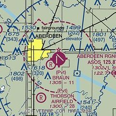
| Sectional chart |
|---|
|
CAUTION: Diagram may not be current

| Airport distance calculator |
|---|
|
|
| Sunrise and sunset |
|---|
|
Times for 19-Dec-2025
| | Local
(UTC-6) | | Zulu
(UTC) |
|---|
| Morning civil twilight | | 07:36 | | 13:36 |
| Sunrise | | 08:10 | | 14:10 |
| Sunset | | 16:51 | | 22:51 |
| Evening civil twilight | | 17:25 | | 23:25 |
|
| Current date and time |
|---|
| Zulu (UTC) | 19-Dec-2025 18:04:28 |
|---|
| Local (UTC-6) | 19-Dec-2025 12:04:28 |
|---|
|
| METAR |
|---|
| KABR | 191753Z AUTO 15015KT M07/M16 A2952 RMK AO2 SLP023 T10721156 11072 21178 $
|
|
| TAF |
|---|
| KABR | 191730Z 1918/2018 17018G27KT P6SM OVC090 FM192300 18010KT P6SM BKN180 FM200200 21007KT P6SM BKN170 PROB30 2002/2006 6SM -FZRA OVC080 FM200700 30015G24KT P6SM BKN090
|
|
| NOTAMs |
|---|
NOTAMs are issued by the DoD/FAA and will open in a separate window not controlled by AirNav.
|
|


