FAA INFORMATION EFFECTIVE 19 FEBRUARY 2026
Location
| FAA Identifier: | 1R7 |
| Lat/Long: | 31-36-21.0000N 090-24-33.5000W
31-36.350000N 090-24.558333W
31.6058333,-90.4093056
(estimated) |
| Elevation: | 492.3 ft. / 150.1 m (surveyed) |
| Variation: | 01W (2025) |
| From city: | 3 miles NE of BROOKHAVEN, MS |
| Time zone: | UTC -6 (UTC -5 during Daylight Saving Time) |
| Zip code: | 39601 |
Airport Operations
| Airport use: | Open to the public |
| Activation date: | 06/1955 |
| Control tower: | no |
| ARTCC: | HOUSTON CENTER |
| FSS: | GREENWOOD FLIGHT SERVICE STATION |
| NOTAMs facility: | GWO (NOTAM-D service available) |
| Attendance: | MON-FRI 0900-1700 |
| Wind indicator: | lighted, WIND INDICATOR LGT OPR DUSK-DAWN. |
| Segmented circle: | yes |
| Lights: | ACTVT MIRL RWY 05/23 - CTAF. PAPI RWY 05 OPR DUSK-DAWN. PAPI RWY 23 OPR CONSLY. |
| Beacon: | white-green (lighted land airport)
Operates sunset to sunrise. |
Airport Communications
| CTAF/UNICOM: | 122.8 |
| WX AWOS-3T: | 118.125 (601-833-3209) |
- APCH/DEP SVC PRVDD BY HOUSTON ARTCC (ZHU) ON FREQS 126.8/327.8 (MC COMB RCAG).
Nearby radio navigation aids
| VOR radial/distance | | VOR name | | Freq | | Var |
|---|
| MCBr334/19.7 | | MC COMB VORTAC | | 116.70 | | 03E |
Airport Services
| Fuel available: | 100LL JET-A+
100LL:FUEL SVC AVBL 24 HRS WITH CREDIT CARD. |
| Parking: | tiedowns |
| Airframe service: | NONE |
| Powerplant service: | NONE |
| Bottled oxygen: | NONE |
| Bulk oxygen: | NONE |
Runway Information
Runway 5/23
| Dimensions: | 5000 x 75 ft. / 1524 x 23 m |
| Surface: | asphalt, in excellent condition |
| Weight bearing capacity: | |
| Runway edge lights: | medium intensity |
| RUNWAY 5 | | RUNWAY 23 |
| Latitude: | 31-36.072722N | | 31-36.628412N |
| Longitude: | 090-24.914757W | | 090-24.202900W |
| Elevation: | 491.4 ft. | | 486.2 ft. |
| Traffic pattern: | left | | left |
| Runway heading: | 049 magnetic, 048 true | | 229 magnetic, 228 true |
| Displaced threshold: | 635 ft. | | 994 ft. |
| Markings: | nonprecision, in good condition | | nonprecision, in good condition |
| Visual slope indicator: | 2-light PAPI on left (3.00 degrees glide path) | | 2-light PAPI on left (3.00 degrees glide path) |
| Touchdown point: | yes, no lights | | yes, no lights |
| Obstructions: | 45 ft. trees, 800 ft. from runway, 100 ft. both sides of centerline, 13:1 slope to clear
APCH RATIO 31:1 FM DTHR. | | 53 ft. trees, 800 ft. from runway, 50 ft. both sides of centerline, 11:1 slope to clear
APCH RATIO 33:1 FM DTHR. |
Airport Ownership and Management from official FAA records
| Ownership: | Publicly-owned |
| Owner: | CITY OF BROOKHAVEN
300 SOUTH 1ST ST
BROOKHAVEN, MS 39601
Phone 601-833-2362 |
| Manager: | JOHN COLEMAN
1216 HEUCKS RETREAT RD
BROOKHAVEN, MS 39601
Phone 601-833-0999
JOE COX |
Additional Remarks
| A30A-23 | TALL TREES AER. |
| - | FOR CD CTC HOUSTON ARTCC AT 281-230-5622. |
| - | COURTESY VEHICLE AVBL. |
Instrument Procedures
NOTE: All procedures below are presented as PDF files. If you need a reader for these files, you should download the free Adobe Reader.NOT FOR NAVIGATION. Please procure official charts for flight.
FAA instrument procedures published for use from 19 February 2026 at 0901Z to 19 March 2026 at 0900Z.
IAPs - Instrument Approach Procedures |
|---|
| RNAV (GPS) RWY 23 | |
download (218KB) |
| NOTE: Special Alternate Minimums apply | |
download (163KB) |
| NOTE: Special Take-Off Minimums/Departure Procedures apply | |
download (308KB) |
Other nearby airports with instrument procedures:
M11 - Copiah County Airport (18 nm N)
M43 - Prentiss-Jefferson Davis County Airport (26 nm E)
KMCB - Mc Comb (Pike County) Airport/John E Lewis Field (26 nm S)
17M - Magee Municipal Airport (35 nm NE)
0R0 - Columbia/Marion County Airport (36 nm SE)
|
|

Road maps at:
MapQuest
Bing
Google
| Aerial photo |
|---|
WARNING: Photo may not be current or correct
 Photo taken 23-Jul-2010
Rwy 4 Bottom
Photo taken 23-Jul-2010
Rwy 4 Bottom
Rwy 22 Top
Do you have a better or more recent aerial photo of Brookhaven-Lincoln County Airport that you would like to share? If so, please send us your photo.
|
| Sectional chart |
|---|
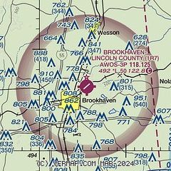
|
| Airport distance calculator |
|---|
|
|
| Sunrise and sunset |
|---|
|
Times for 15-Mar-2026
| | Local
(UTC-5) | | Zulu
(UTC) |
|---|
| Morning civil twilight | | 06:48 | | 11:48 |
| Sunrise | | 07:13 | | 12:13 |
| Sunset | | 19:09 | | 00:09 |
| Evening civil twilight | | 19:33 | | 00:33 |
|
| Current date and time |
|---|
| Zulu (UTC) | 15-Mar-2026 08:31:04 |
|---|
| Local (UTC-5) | 15-Mar-2026 03:31:04 |
|---|
|
| TAF |
|---|
KMCB
26nm S | 150520Z 1506/1606 15005KT P6SM FEW035 SCT250 FM151000 17005KT P6SM BKN020 FM151800 19013KT P6SM FEW030 SCT250 PROB30 1601/1603 4SM -TSRA BKN025CB FM160300 22015G24KT 2SM SHRA SCT015 BKN035 WS020/23040KT PROB30 1603/1605 30025G35KT 1SM TSRA BKN015CB FM160500 33017G26KT P6SM BKN025 WS020/34050KT PROB30 1605/1606 4SM -SHRA OVC015
|
|
| NOTAMs |
|---|
NOTAMs are issued by the DoD/FAA and will open in a separate window not controlled by AirNav.
|
|

