FAA INFORMATION EFFECTIVE 19 MARCH 2026
Location
| FAA Identifier: | 24A |
| Lat/Long: | 35-19-01.9600N 083-12-34.9330W
35-19.032667N 083-12.582217W
35.3172111,-83.2097036
(estimated) |
| Elevation: | 2857 ft. / 870.8 m (surveyed) |
| Variation: | 05W (2000) |
| From city: | 3 miles SE of SYLVA, NC |
| Time zone: | UTC -4 (UTC -5 during Standard Time) |
| Zip code: | 28779 |
Airport Operations
| Airport use: | Open to the public |
| Activation date: | 09/1978 |
| Control tower: | no |
| ARTCC: | ATLANTA CENTER |
| FSS: | RALEIGH FLIGHT SERVICE STATION |
| NOTAMs facility: | RDU (NOTAM-D service available) |
| Attendance: | UNATNDD |
| Wind indicator: | lighted |
| Segmented circle: | yes |
| Lights: | AFTER SS ACTVT REIL RWY 33; PAPI RWY 15 & 33; MIRL RWY 15/33 - CTAF. |
| Beacon: | white-green (lighted land airport)
Operates sunset to sunrise. |
Airport Communications
| CTAF/UNICOM: | 123.0 |
| WX AWOS-3PT: | 118.9 (828-631-3389) |
| WX AWOS-3P at 1A5 (12 nm SW): | 118.225 (828-349-3156) |
- APCH/DEP SVC PRVDD BY ATLANTA ARTCC (ZTL) ON FREQS 134.8/379.95 (MOUNT OGLETHORPE RCAG).
Nearby radio navigation aids
| VOR radial/distance | | VOR name | | Freq | | Var |
|---|
| SOTr199/29.4 | | SNOWBIRD VORTAC | | 108.80 | | 04W |
| ODFr007/37.5 | | FOOTHILLS VOR/DME | | 113.40 | | 00E |
| NDB name | | Hdg/Dist | | Freq | | Var | | ID |
|---|
| BROAD RIVER | | 281/36.3 | | 379 | | 07W | | BRA | -... .-. .- |
Airport Services
| Fuel available: | 100LL
100LL:FUEL 24 HOUR CREDIT CARD SVC AVBL. |
| Parking: | tiedowns |
| Airframe service: | NONE |
| Powerplant service: | NONE |
| Bottled oxygen: | NONE |
| Bulk oxygen: | NONE |
Runway Information
Runway 15/33
| Dimensions: | 3210 x 60 ft. / 978 x 18 m |
| Surface: | asphalt, in good condition |
| Weight bearing capacity: | |
| Runway edge lights: | medium intensity |
| RUNWAY 15 | | RUNWAY 33 |
| Latitude: | 35-19.240830N | | 35-18.824512N |
| Longitude: | 083-12.781257W | | 083-12.383198W |
| Elevation: | 2856.6 ft. | | 2806.6 ft. |
| Traffic pattern: | left | | left |
| Runway heading: | 147 magnetic, 142 true | | 327 magnetic, 322 true |
| Displaced threshold: | no | | 150 ft. |
| Markings: | nonprecision, in good condition | | nonprecision, in good condition |
| Visual slope indicator: | 2-light PAPI on left (3.50 degrees glide path)
UNUSBL BYD 8 DEG LEFT OF CNTRLN. | | 2-light PAPI on left (3.09 degrees glide path) |
| Runway end identifier lights: | yes
NOTAM IN EFFECT - OTS INDEFLY. | | yes |
| Touchdown point: | yes, no lights | | yes, no lights |
| Obstructions: | 13 ft. trees, 640 ft. from runway, 91 ft. right of centerline, 33:1 slope to clear | | 10 ft. brush, 236 ft. from runway, 25 ft. left of centerline, 3:1 slope to clear
DSPLD THLD SLOPE 18:1 . |
Airport Ownership and Management from official FAA records
| Ownership: | Publicly-owned |
| Owner: | JACKSON CO ARPT AUTHORITY
401 GRINDSTAFF COVE RD, SUITE A-207
SYLVA, NC 28779
Phone 828-631-2295 |
| Manager: | JIM ROWELL
401 GRINDSTAFF COVE RD, SUITE A-207
SYLVA, NC 28779
Phone 828-586-0321 |
Additional Remarks
| - | NO DSGND HELI AT THIS ARPT - ARPT MASTER RECORD INCORRECTLY DESIGNATES H1 EXISTS. |
| - | MTN HAZ RED BCN LGTS LCTD ON MTN RANGE APPROX 1.7 MILES SSW OF ARPT - LGTS OPN UNRELBL. |
| - | RWY 15 300 FT DROP-OFF 300 FT FM THLD BOTH SIDES AND 90 FT LEFT/RIGHT OF CNTRLN ALONG RWY. |
| - | RWY 33 300 FT DROP-OFF 200 FT FM THLD 50 FT LEFT OF CNTRLN. |
| - | RPDLY RSG TRRN ALL QUADS. |
| - | FOR CD CTC ATLANTA ARTCC AT 770-210-7692. |
| - | COLD TEMPERATURE AIRPORT. ALTITUDE CORRECTION REQUIRED AT OR BELOW -13C. |
Instrument Procedures
NOTE: All procedures below are presented as PDF files. If you need a reader for these files, you should download the free Adobe Reader.NOT FOR NAVIGATION. Please procure official charts for flight.
FAA instrument procedures published for use from 19 March 2026 at 0901Z to 16 April 2026 at 0900Z.
IAPs - Instrument Approach Procedures |
|---|
| RNAV (GPS) RWY 33 | |
download (191KB) |
| NOTE: Special Alternate Minimums apply | |
download (135KB) |
| NOTE: Special Take-Off Minimums/Departure Procedures apply | |
download (384KB) |
Other nearby airports with instrument procedures:
1A5 - Macon County Airport (12 nm SW)
KRHP - Western Carolina Regional Airport (33 nm W)
KAVL - Asheville Regional Airport (33 nm E)
KGKT - Gatlinburg-Pigeon Forge Airport (36 nm NW)
KLQK - Pickens County Airport (39 nm SE)
|
|

Road maps at:
MapQuest
Bing
Google
| Aerial photo |
|---|
WARNING: Photo may not be current or correct
 Photographer: Nick Breedlove
Pilot: Mike Schoonover
Photo taken 09-Sep-2012
looking northwest.
Do you have a better or more recent aerial photo of Jackson County Airport that you would like to share? If so, please send us your photo.
|
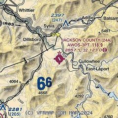
| Sectional chart |
|---|
|
| Airport distance calculator |
|---|
|
|
| Sunrise and sunset |
|---|
|
Times for 11-Apr-2026
| | Local
(UTC-4) | | Zulu
(UTC) |
|---|
| Morning civil twilight | | 06:41 | | 10:41 |
| Sunrise | | 07:07 | | 11:07 |
| Sunset | | 20:01 | | 00:01 |
| Evening civil twilight | | 20:27 | | 00:27 |
|
| Current date and time |
|---|
| Zulu (UTC) | 11-Apr-2026 11:19:30 |
|---|
| Local (UTC-4) | 11-Apr-2026 07:19:30 |
|---|
|
| METAR |
|---|
| K24A | 111055Z AUTO 13003KT 10SM CLR 09/01 A3037 RMK AO2 T00890014
|
K1A5
12nm SW | 111055Z AUTO 00000KT 10SM CLR 02/02 A3040 RMK AO2 T00190015
|
|
| TAF |
|---|
KAVL
34nm E | 110531Z 1106/1206 VRB02KT P6SM SCT250 FM111600 35005KT P6SM FEW240 FM120000 VRB02KT P6SM SCT240
|
|
| NOTAMs |
|---|
NOTAMs are issued by the DoD/FAA and will open in a separate window not controlled by AirNav.
|
|

