FAA INFORMATION EFFECTIVE 19 FEBRUARY 2026
Location
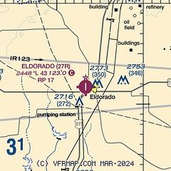
| FAA Identifier: | 27R |
| Lat/Long: | 30-51-44.0000N 100-36-39.1000W
30-51.733333N 100-36.651667W
30.8622222,-100.6108611
(estimated) |
| Elevation: | 2448 ft. / 746 m (estimated) |
| Variation: | 08E (1985) |
| From city: | 1 mile W of ELDORADO, TX |
| Time zone: | UTC -6 (UTC -5 during Daylight Saving Time) |
| Zip code: | 76936 |
Airport Operations
| Airport use: | Open to the public |
| Activation date: | 03/1943 |
| Control tower: | no |
| ARTCC: | FORT WORTH CENTER |
| FSS: | SAN ANGELO FLIGHT SERVICE STATION |
| NOTAMs facility: | SJT (NOTAM-D service available) |
| Attendance: | UNATNDD |
| Wind indicator: | lighted |
| Segmented circle: | no |
| Lights: | MIRL RWY 17/35 PRESET TO LOW INTST, TO INCR INTST AND ACTVT PAPI - CTAF. |
| Beacon: | white-green (lighted land airport)
Operates sunset to sunrise. |
Airport Communications
| CTAF/UNICOM: | 123.0 |
| WX AWOS-3 at SOA (17 nm S): | 118.075 (325-387-3801) |
| WX AWOS-3 at 9TE2 (20 nm SE): | 120.425 (325-276-2771) |
Nearby radio navigation aids
| VOR radial/distance | | VOR name | | Freq | | Var |
|---|
| SJTr185/31.8 | | SAN ANGELO VORTAC | | 115.10 | | 10E |
| NDB name | | Hdg/Dist | | Freq | | Var | | ID |
|---|
| SONORA | | 358/16.9 | | 371 | | 08E | | SOA | ... --- .- |
Airport Services
| Fuel available: | 100LL
100LL:FOR FUEL CALL 325-853-2036/2737 OR 325-650-9553 |
| Parking: | tiedowns |
| Airframe service: | NONE |
| Powerplant service: | NONE |
Runway Information
Runway 17/35
| Dimensions: | 4300 x 60 ft. / 1311 x 18 m |
| Surface: | asphalt, in good condition |
| Weight bearing capacity: | |
| Runway edge lights: | medium intensity |
| RUNWAY 17 | | RUNWAY 35 |
| Latitude: | 30-52.088187N | | 30-51.378712N |
| Longitude: | 100-36.653822W | | 100-36.649518W |
| Elevation: | 2444.0 ft. | | 2435.0 ft. |
| Traffic pattern: | right | | left |
| Runway heading: | 172 magnetic, 180 true | | 352 magnetic, 360 true |
| Markings: | nonprecision, in good condition | | nonprecision, in good condition |
| Visual slope indicator: | 2-light PAPI on left (3.00 degrees glide path) | | 2-light PAPI on left (3.00 degrees glide path) |
| Obstructions: | 32 ft. pole, 535 ft. from runway, 160 ft. right of centerline, 10:1 slope to clear
RWY 34 ALSO 65 FT PWRLINE, 1425 FT DSTC, 0 FT BOTH, 18:1. NOT MKD. | | 15 ft. road, 450 ft. from runway, 16:1 slope to clear |
Airport Ownership and Management from official FAA records
| Ownership: | Publicly-owned |
| Owner: | SCHLEICHER COUNTY
COUNTY COURTHOUSE
ELDORADO, TX 76936
Phone 325-853-2593 |
| Manager: | CHARLIE BRADLEY /CO JUDGE/
P.O. BOX 536
ELDORADO, TX 76936
Phone 325-853-2593 |
Additional Remarks
| - | FOR CD CTC SAN ANGELO APCH AT 432-563-2123. WHEN APCH CLSD CTC FORT WORTH ARTCC AT 817-858-7584. |
Instrument Procedures
There are no published instrument procedures at 27R.
Some nearby airports with instrument procedures:
KSOA - Sonora Municipal Airport (17 nm S)
KSJT - San Angelo Regional Airport/Mathis Field (30 nm N)
KOZA - Ozona Municipal Airport (31 nm W)
KJCT - Kimble County Airport (49 nm SE)
E41 - Reagan County Airport (49 nm NW)
|
|

Road maps at:
MapQuest
Bing
Google
| Aerial photo |
|---|
WARNING: Photo may not be current or correct
 Photo taken 09-Sep-2011
looking south.
Photo taken 09-Sep-2011
looking south.
Do you have a better or more recent aerial photo of Eldorado Airport that you would like to share? If so, please send us your photo.
|
| Sectional chart |
|---|
|
| Airport distance calculator |
|---|
|
|
| Sunrise and sunset |
|---|
|
Times for 22-Feb-2026
| | Local
(UTC-6) | | Zulu
(UTC) |
|---|
| Morning civil twilight | | 06:53 | | 12:53 |
| Sunrise | | 07:17 | | 13:17 |
| Sunset | | 18:35 | | 00:35 |
| Evening civil twilight | | 18:59 | | 00:59 |
|
| Current date and time |
|---|
| Zulu (UTC) | 22-Feb-2026 09:16:56 |
|---|
| Local (UTC-6) | 22-Feb-2026 03:16:56 |
|---|
|
| METAR |
|---|
KSOA
17nm S | 220855Z AUTO 00000KT 01/M06 A3060 RMK AO2
|
KSJT
31nm N | 220851Z AUTO 25004KT 10SM CLR M02/M06 A3057 RMK AO2 SLP355 T10171061 50007
|
KOZA
31nm W | 220855Z AUTO 10SM CLR 00/M08 A3059 RMK AO2
|
|
| TAF |
|---|
KSOA
17nm S | 220520Z 2206/2306 03008KT P6SM SKC AMD NOT SKED
|
|
| NOTAMs |
|---|
NOTAMs are issued by the DoD/FAA and will open in a separate window not controlled by AirNav.
|
|

