FAA INFORMATION EFFECTIVE 14 MAY 2026
Location
| FAA Identifier: | 28N |
| Lat/Long: | 39-32-22.5000N 074-58-03.6000W
39-32.375000N 074-58.060000W
39.5395833,-74.9676667
(estimated) |
| Elevation: | 120 ft. / 37 m (estimated) |
| Variation: | 11W (1985) |
| From city: | 4 miles NE of VINELAND, NJ |
| Time zone: | UTC -4 (UTC -5 during Standard Time) |
| Zip code: | 08360 |
Airport Operations
| Airport use: | Open to the public |
| Activation date: | 08/1945 |
| Control tower: | no |
| ARTCC: | WASHINGTON CENTER |
| FSS: | MILLVILLE FLIGHT SERVICE STATION |
| NOTAMs facility: | MIV (NOTAM-D service available) |
| Attendance: | DEC-MAR UNATTND UNATTND, APR-NOV 0800-1600 |
| Pattern altitude: | 1320 ft. MSL |
| Wind indicator: | yes |
| Segmented circle: | no |
| Lights: | ARPT LGTS PPR CALL 856-697-3300. |
Airport Communications
| CTAF/UNICOM: | 122.8 |
| WX ASOS at MIV (11 nm SW): | 119.6 (856-327-3455) |
| WX AWOS-AV at N81 (12 nm NE): | 122.7 |
| WX ASOS at ACY (19 nm E): | PHONE 609-277-2644 |
Nearby radio navigation aids
| VOR radial/distance | | VOR name | | Freq | | Var |
|---|
| VCN at field | | CEDAR LAKE VOR/DME | | 115.20 | | 10W |
| OODr120/16.6 | | WOODSTOWN VORTAC | | 112.80 | | 10W |
| ACYr295/18.8 | | ATLANTIC CITY VORTAC | | 117.15 | | 10W |
| SIEr353/27.8 | | SEA ISLE VORTAC | | 114.80 | | 09W |
| CYNr246/29.8 | | COYLE VORTAC | | 113.40 | | 10W |
| DQOr116/30.7 | | DUPONT VORTAC | | 114.00 | | 10W |
| ENOr063/31.4 | | SMYRNA VORTAC | | 111.40 | | 09W |
| GXUr223/33.0 | | MC GUIRE VORTAC | | 110.60 | | 12W |
| MXEr134/39.6 | | MODENA VORTAC | | 113.20 | | 09W |
| NDB name | | Hdg/Dist | | Freq | | Var | | ID |
|---|
| RAINBOW | | 058/10.6 | | 363 | | 11W | | RNB | .-. -. -... |
Airport Services
| Fuel available: | 100LL JET-A
100LL:FOR FUEL PHONE 856-697-3300. |
| Parking: | tiedowns |
| Airframe service: | MAJOR |
| Powerplant service: | MAJOR |
| Bottled oxygen: | NONE |
| Bulk oxygen: | NONE |
Runway Information
Runway 2/20
| Dimensions: | 2251 x 100 ft. / 686 x 30 m |
| Surface: | turf, in good condition |
| Runway edge lights: | low intensity
RWY 02/20 NONSTANDARD LIRL DUE TO SPACING. THLD & RWY END LGTS NONSTANDARD COLORS. |
| RUNWAY 2 | | RUNWAY 20 |
| Traffic pattern: | left | | left |
| Markings: | none | | none |
| Obstructions: | 40 ft. tree, 404 ft. from runway, 161 ft. left of centerline, 10:1 slope to clear | | 21 ft. bldg, lighted, 279 ft. from runway, 138 ft. right of centerline, 13:1 slope to clear
ADDITIONAL OBSTR: TREES TO 80-130 FT BEFORE LDG THLD, 200 FT RT OF CTLN & 40 FT MKD/LGTD PLINE 500 FT BEFORE LDG THLD. |
Runway 12/30
| Dimensions: | 1800 x 100 ft. / 549 x 30 m |
| Surface: | turf, in good condition |
| RUNWAY 12 | | RUNWAY 30 |
| Latitude: | 39-32.432598N | | 39-32.315850N |
| Longitude: | 074-58.236612W | | 074-57.884512W |
| Elevation: | 118.0 ft. | | 120.0 ft. |
| Traffic pattern: | left | | left |
| Runway heading: | 124 magnetic, 113 true | | 304 magnetic, 293 true |
| Markings: | none | | none |
| Obstructions: | 4 ft. fence, 18 ft. from runway, 4:1 slope to clear | | 4 ft. fence, 18 ft. from runway, 4:1 slope to clear |
Airport Ownership and Management from official FAA records
| Ownership: | Privately-owned |
| Owner: | DOWNSTOWN ARPT. INC.
339 HARDING HWY
VINELAND, NJ 08360
Phone 856-697-3300 |
| Manager: | CURTIS NIXHOLM
339 HARDING HWY
VINELAND, NJ 08360
Phone 856-207-6027 |
Additional Remarks
| - | ARPT CLSD AT NIGHT TO TRANSIENTS. |
| - | HEAVY AGRICULTURAL OPNS APR-OCT. |
| - | RADIO CTL MODELS OPR ON RY 12. |
| - | RY 12/30 RESTRICTED TO AGRICULTURAL AND FIREFIGHTING ACFT ONLY. |
| - | FOR CD CTC WASHINGTON ARTCC AT 703-771-3587. |
Instrument Procedures
There are no published instrument procedures at 28N.
Some nearby airports with instrument procedures:
17N - Cross Keys Airport (10 nm N)
KMIV - Millville Municipal Airport (11 nm SW)
N81 - Hammonton Municipal Airport (12 nm NE)
19N - Pine Valley Airport (14 nm N)
KACY - Atlantic City International Airport (19 nm E)
|
|

Road maps at:
MapQuest
Bing
Google
| Aerial photo |
|---|
WARNING: Photo may not be current or correct
 Photo taken 05-Nov-2006
from a Mooney at 6,000 feet MSL.
Photo taken 05-Nov-2006
from a Mooney at 6,000 feet MSL.
Notice the Cedar Lake VOR on the field
Do you have a better or more recent aerial photo of Vineland-Downstown Airport that you would like to share? If so, please send us your photo.
|
| Sectional chart |
|---|
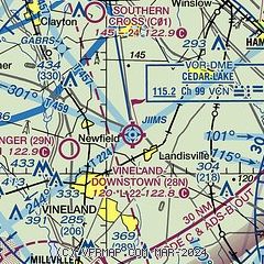
|
| Airport distance calculator |
|---|
|
|
| Sunrise and sunset |
|---|
|
Times for 10-Jun-2026
| | Local
(UTC-4) | | Zulu
(UTC) |
|---|
| Morning civil twilight | | 05:01 | | 09:01 |
| Sunrise | | 05:33 | | 09:33 |
| Sunset | | 20:25 | | 00:25 |
| Evening civil twilight | | 20:58 | | 00:58 |
|
| Current date and time |
|---|
| Zulu (UTC) | 10-Jun-2026 09:11:54 |
|---|
| Local (UTC-4) | 10-Jun-2026 05:11:54 |
|---|
|
| METAR |
|---|
KMIV
12nm SW | 100854Z AUTO VRB03KT 10SM FEW120 19/14 A3001 RMK AO2 SLP160 T01940144 58013 $
|
KACY
18nm E | 100854Z AUTO 20004KT 10SM CLR 20/13 A3001 RMK AO2 SLP162 T02000128 56013 $
|
KPHL
23nm NW | 100854Z 18006KT 10SM FEW040 SCT095 OVC140 21/16 A2999 RMK AO2 SLP155 60000 T02060156 56017 $
|
|
| TAF |
|---|
KMIV
12nm SW | 100539Z 1006/1106 19005KT P6SM VCSH BKN100 FM101400 21009KT P6SM BKN025 FM101900 21010G18KT P6SM VCSH SCT025 OVC040 TEMPO 1022/1101 3SM TSRA BR BKN025CB FM110200 22005KT 6SM BR SCT020
|
KACY
18nm E | 100539Z 1006/1106 19005KT P6SM VCSH BKN100 FM101400 21009KT P6SM BKN025 FM101900 21010G18KT P6SM VCSH SCT025 OVC040 TEMPO 1022/1101 3SM TSRA BR BKN025CB FM110200 22005KT 6SM BR SCT020
|
|
| NOTAMs |
|---|
NOTAMs are issued by the DoD/FAA and will open in a separate window not controlled by AirNav.
|
|

