FAA INFORMATION EFFECTIVE 22 JANUARY 2026
Location
| FAA Identifier: | MIV |
| Lat/Long: | 39-22-04.1000N 075-04-20.0000W
39-22.068333N 075-04.333333W
39.3678056,-75.0722222
(estimated) |
| Elevation: | 84.6 ft. / 25.8 m (surveyed) |
| Variation: | 11W (1985) |
| From city: | 3 miles SW of MILLVILLE, NJ |
| Time zone: | UTC -5 (UTC -4 during Daylight Saving Time) |
| Zip code: | 08332 |
Airport Operations
| Airport use: | Open to the public |
| Activation date: | 05/1943 |
| Control tower: | no |
| ARTCC: | WASHINGTON CENTER |
| FSS: | MILLVILLE FLIGHT SERVICE STATION |
| NOTAMs facility: | MIV (NOTAM-D service available) |
| Attendance: | 0800-1600 |
| Wind indicator: | lighted |
| Segmented circle: | no |
| Lights: | ACTVT MALSR RWY 10; MIRL 10/28 & 14/32 - CTAF. |
| Beacon: | white-green (lighted land airport)
Operates sunset to sunrise. |
Airport Communications
| CTAF/UNICOM: | 123.0 |
| WX ASOS: | 119.6 (856-327-3455) |
| ATLANTIC CITY APPROACH: | 124.6 |
| ATLANTIC CITY DEPARTURE: | 124.6 |
| WX AWOS-3 at OBI (16 nm SE): | 120.475 (609-861-0610) |
Nearby radio navigation aids
| VOR radial/distance | | VOR name | | Freq | | Var |
|---|
| VCNr216/11.3 | | CEDAR LAKE VOR/DME | | 115.20 | | 10W |
| OODr156/19.3 | | WOODSTOWN VORTAC | | 112.80 | | 10W |
| SIEr331/20.7 | | SEA ISLE VORTAC | | 114.80 | | 09W |
| ENOr077/22.2 | | SMYRNA VORTAC | | 111.40 | | 09W |
| ACYr267/23.6 | | ATLANTIC CITY VORTAC | | 117.15 | | 10W |
| DQOr137/31.0 | | DUPONT VORTAC | | 114.00 | | 10W |
| ATRr020/34.1 | | WATERLOO VOR/DME | | 112.60 | | 09W |
| NDB name | | Hdg/Dist | | Freq | | Var | | ID |
|---|
| RAINBOW | | 147/4.2 | | 363 | | 11W | | RNB | .-. -. -... |
Airport Services
| Fuel available: | 100LL JET-A
100LL:SELF SERV AVBL 24 HRS WITH CREDIT CARD. |
| Parking: | tiedowns |
| Airframe service: | NONE |
| Powerplant service: | MINOR |
| Bottled oxygen: | NONE |
| Bulk oxygen: | NONE |
Runway Information
Runway 10/28
| Dimensions: | 6003 x 150 ft. / 1830 x 46 m |
| Surface: | asphalt/grooved, in good condition |
| Weight bearing capacity: | | PCN 55 /F/D/W/T | | Single wheel: | 120.0 | | Double wheel: | 179.0 | | Double tandem: | 263.0 |
|
| Runway edge lights: | medium intensity |
| RUNWAY 10 | | RUNWAY 28 |
| Latitude: | 39-22.022453N | | 39-22.021952N |
| Longitude: | 075-04.944168W | | 075-03.670325W |
| Elevation: | 73.5 ft. | | 84.4 ft. |
| Traffic pattern: | left | | left |
| Runway heading: | 101 magnetic, 090 true | | 281 magnetic, 270 true |
| Markings: | precision, in good condition | | nonprecision, in good condition |
| Visual slope indicator: | 4-light PAPI on left (3.00 degrees glide path) | | 4-light PAPI on left (3.00 degrees glide path) |
| Approach lights: | MALSR: 1,400 foot medium intensity approach lighting system with runway alignment indicator lights | | |
| Runway end identifier lights: | no | | no |
| Touchdown point: | yes, no lights | | yes, no lights |
| Instrument approach: | ILS | | |
| Obstructions: | 65 ft. trees, 2480 ft. from runway, 170 ft. left of centerline, 35:1 slope to clear | | none |
Runway 14/32
| Dimensions: | 5058 x 150 ft. / 1542 x 46 m |
| Surface: | concrete, in good condition |
| Weight bearing capacity: | | PCN 19 /R/C/W/T | | Single wheel: | 45.5 | | Double wheel: | 68.0 | | Double tandem: | 229.0 |
|
| Runway edge lights: | medium intensity |
| RUNWAY 14 | | RUNWAY 32 |
| Latitude: | 39-22.417338N | | 39-21.828003N |
| Longitude: | 075-04.742970W | | 075-03.984352W |
| Elevation: | 80.7 ft. | | 82.2 ft. |
| Traffic pattern: | left | | left |
| Runway heading: | 146 magnetic, 135 true | | 326 magnetic, 315 true |
| Markings: | nonprecision, in good condition | | nonprecision, in good condition |
| Visual slope indicator: | 4-light PAPI on left (3.00 degrees glide path) | | 4-light PAPI on left (3.00 degrees glide path) |
| Touchdown point: | yes, no lights | | yes, no lights |
| Obstructions: | 49 ft. trees, 2160 ft. from runway, 190 ft. left of centerline, 40:1 slope to clear | | 55 ft. trees, 1335 ft. from runway, 20:1 slope to clear |
Airport Ownership and Management from official FAA records
| Ownership: | Publicly-owned |
| Owner: | DRBA-CITY OF MILLVILLE
104 LEDDON ST
MILLVILLE, NJ 08332
Phone 856-825-1244 |
| Manager: | JOE MULHERON
ADMIN BLDG, 104 LEDDON ST
MILLVILLE, NJ 08332
Phone 302-757-2952 |
Additional Remarks
| A30A-10 | CALM WIND RWY. |
| - | MAIN APN CLSD TO TSNT ACFT N OF TWY K. |
| - | BIRDS ON & INVOF ARPT. |
| - | FOR CD IF UNA TO CTC ON FSS FREQ, CTC ATLANTIC CITY APPROACH AT 609-485-6193. |
| - | FENCE LINE 44 FT N OF TWY G CNTRLN, N OF TWY A. |
| - | ARPT SFC CONDS NOT RPRTD 0800-1600. |
| - | ALL ULTRALIGHT ACFT, GLDR OPS & FRMN FLTS PPR. CALL 856-825-1244 MON-FRI 0800-1600. |
| - | PAEW WI ALL RWY & TWY SAFETY AREAS DLY MAY-OCT. |
| - | TWY G NOT TO BE USED BY ACFT WITH WINGSPAN GTR THAN 48 FT N OF TWY A. |
Instrument Procedures
NOTE: All procedures below are presented as PDF files. If you need a reader for these files, you should download the free Adobe Reader.NOT FOR NAVIGATION. Please procure official charts for flight.
FAA instrument procedures published for use from 22 January 2026 at 0901Z to 19 February 2026 at 0900z.
IAPs - Instrument Approach Procedures |
|---|
| ILS OR LOC RWY 10 | |
download (296KB) |
| RNAV (GPS) RWY 10 | |
download (259KB) |
| RNAV (GPS) RWY 14 | |
download (220KB) |
| RNAV (GPS) RWY 28 | |
download (259KB) |
| RNAV (GPS) RWY 32 | |
download (282KB) |
| VOR-A | |
download (182KB) |
| NOTE: Special Alternate Minimums apply | |
download (129KB) |
Departure Procedures |
|---|
| LEEAH SIX | |
download (175KB) |
| NOTE: Special Take-Off Minimums/Departure Procedures apply | |
download (150KB) |
Other nearby airports with instrument procedures:
KOBI - Woodbine Municipal Airport (16 nm SE)
17N - Cross Keys Airport (20 nm N)
26N - Ocean City Municipal Airport (22 nm E)
KWWD - Cape May County Airport (23 nm S)
N81 - Hammonton Municipal Airport (23 nm NE)
|
|

Road maps at:
MapQuest
Bing
Google
| Aerial photo |
|---|
WARNING: Photo may not be current or correct
 Photo taken 22-Apr-2011
looking northwest.
Photo taken 22-Apr-2011
looking northwest.
Do you have a better or more recent aerial photo of Millville Municipal Airport that you would like to share? If so, please send us your photo.
|
| Sectional chart |
|---|
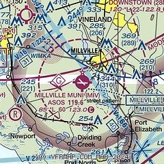
|
| Airport distance calculator |
|---|
|
|
| Sunrise and sunset |
|---|
|
Times for 07-Feb-2026
| | Local
(UTC-5) | | Zulu
(UTC) |
|---|
| Morning civil twilight | | 06:35 | | 11:35 |
| Sunrise | | 07:03 | | 12:03 |
| Sunset | | 17:26 | | 22:26 |
| Evening civil twilight | | 17:54 | | 22:54 |
|
| Current date and time |
|---|
| Zulu (UTC) | 07-Feb-2026 16:57:40 |
|---|
| Local (UTC-5) | 07-Feb-2026 11:57:40 |
|---|
|
| METAR |
|---|
| KMIV | 071654Z AUTO 31024G42KT 10SM CLR M09/M22 A2983 RMK AO2 PK WND 32045/1620 SLP101 T10941217
|
|
| TAF |
|---|
| KMIV | 071121Z 0712/0812 32020G30KT P6SM OVC050 TEMPO 0712/0714 3SM -SN FM071400 32028G48KT P6SM BKN050 FM072300 32025G43KT P6SM SCT250 FM080300 32020G35KT P6SM SCT250 FM080700 32015G25KT P6SM SCT250
|
|
| NOTAMs |
|---|
NOTAMs are issued by the DoD/FAA and will open in a separate window not controlled by AirNav.
|
|


