FAA INFORMATION EFFECTIVE 11 JUNE 2026
Location
| FAA Identifier: | 2B2 |
| Lat/Long: | 42-47-43.3000N 070-50-22.0000W
42-47.721667N 070-50.366667W
42.7953611,-70.8394444
(estimated) |
| Elevation: | 11 ft. / 3 m (estimated) |
| Variation: | 16W (1985) |
| From city: | 1 mile SE of NEWBURYPORT, MA |
| Time zone: | UTC -4 (UTC -5 during Standard Time) |
| Zip code: | 01951 |
Airport Operations
| Airport use: | Open to the public |
| Activation date: | 04/1940 |
| Control tower: | no |
| ARTCC: | BOSTON CENTER |
| FSS: | BRIDGEPORT FLIGHT SERVICE STATION |
| NOTAMs facility: | BDR (NOTAM-D service available) |
| Attendance: | APR-SEP 0800-1800, OCT-MAR IREG IREG |
| Wind indicator: | yes |
| Segmented circle: | no |
Airport Communications
| CTAF/UNICOM: | 123.0 |
| BOSTON APPROACH: | 124.4 |
| BOSTON DEPARTURE: | 124.4 |
| WX ASOS at BVY (13 nm S): | 119.2 (978-921-5042) |
| WX ASOS at LWM (13 nm W): | PHONE 978-687-8017 |
Nearby radio navigation aids
| VOR radial/distance | | VOR name | | Freq | | Var |
|---|
| BOSr030/27.1 | | BOSTON VOR/DME | | 112.70 | | 16W |
| ENEr212/39.1 | | KENNEBUNK VOR/DME | | 117.10 | | 17W |
| NDB name | | Hdg/Dist | | Freq | | Var | | ID |
|---|
| ROLLINS | | 197/25.5 | | 260 | | 16W | | ESG | . ... --. |
Airport Services
| Fuel available: | 100LL |
| Parking: | tiedowns |
| Airframe service: | MAJOR |
| Powerplant service: | MAJOR |
| Bottled oxygen: | NONE |
| Bulk oxygen: | NONE |
Runway Information
Runway 10/28
| Dimensions: | 2105 x 50 ft. / 642 x 15 m |
| Surface: | asphalt, in fair condition |
| Weight bearing capacity: | |
| RUNWAY 10 | | RUNWAY 28 |
| Latitude: | 42-47.711833N | | 42-47.731000N |
| Longitude: | 070-50.601833W | | 070-50.132000W |
| Traffic pattern: | left | | left |
| Runway heading: | 103 magnetic, 087 true | | 283 magnetic, 267 true |
| Displaced threshold: | no | | 300 ft. |
| Markings: | basic, in fair condition | | basic, in fair condition |
| Obstructions: | 100 ft. trees, 500 ft. from runway, 100 ft. both sides of centerline, 3:1 slope to clear | | 8 ft. fence, 300 ft. from runway, 55 ft. both sides of centerline, 10:1 slope to clear
4 FT UNLIT FENCE CROSSES RWY. VEHICLE AND EQUIP INVOF RWY. |
Runway 14/32
| Dimensions: | 2300 x 100 ft. / 701 x 30 m |
| Surface: | turf |
| RUNWAY 14 | | RUNWAY 32 |
| Traffic pattern: | left | | left |
| Obstructions: | 14 ft. trees, 200 ft. from runway, 125 ft. left of centerline, 14:1 slope to clear | | 66 ft. trees, 400 ft. from runway, 35 ft. left of centerline, 6:1 slope to clear |
Airport Ownership and Management from official FAA records
| Ownership: | Privately-owned
HNE, HISTORIC NEW ENGLAND INC. |
| Owner: | SPNEA
141 CAMBRIDGE STREET
BOSTON, MA 02114
Phone 617-227-3956 |
| Manager: | STEPHEN NOYES/RICHARD COPITHORNE
24 PLUM ISLAND TURNPIKE
NEWBURY, MA 01951
Phone 978-463-4222 |
Additional Remarks
| - | NO TGLS ALLOWED. |
| - | WILDLIFE INVOF ARPT. |
| - | FOR CD CTC BOSTON APCH AT 603-594-5552. |
| - | CTC MGR FOR ALL ARPT USE REQS. OWNER DOES NOT OVERSEE OPS. |
Instrument Procedures
There are no published instrument procedures at 2B2.
Some nearby airports with instrument procedures:
KBVY - Beverly Regional Airport (13 nm S)
KLWM - Lawrence Municipal Airport (13 nm W)
KPSM - Portsmouth International Airport at Pease (17 nm N)
3B4 - Seacoast Airfield (21 nm N)
KBOS - General Edward Lawrence Logan International Airport (27 nm S)
|
|

Road maps at:
MapQuest
Bing
Google
| Aerial photo |
|---|
WARNING: Photo may not be current or correct
 Photo by Capt. WF Sorenson, Jr.
Photo taken 02-Jul-2020
from 3500 feet looking southwest.
Photo by Capt. WF Sorenson, Jr.
Photo taken 02-Jul-2020
from 3500 feet looking southwest.
Do you have a better or more recent aerial photo of Plum Island Airport that you would like to share? If so, please send us your photo.
|
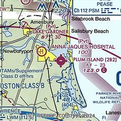
| Sectional chart |
|---|
|
| Airport distance calculator |
|---|
|
|
| Sunrise and sunset |
|---|
|
Times for 22-Jun-2026
| | Local
(UTC-4) | | Zulu
(UTC) |
|---|
| Morning civil twilight | | 04:31 | | 08:31 |
| Sunrise | | 05:06 | | 09:06 |
| Sunset | | 20:24 | | 00:24 |
| Evening civil twilight | | 21:00 | | 01:00 |
|
| Current date and time |
|---|
| Zulu (UTC) | 22-Jun-2026 07:43:26 |
|---|
| Local (UTC-4) | 22-Jun-2026 03:43:26 |
|---|
|
| METAR |
|---|
KBVY
13nm S | 220653Z AUTO 00000KT 10SM CLR 14/14 A2998 RMK AO2 SLP145 T01390139
|
KLWM
14nm W | 220654Z AUTO 19003KT 10SM CLR 15/14 A2999 RMK AO2 SLP157 T01500144
|
KPSM
16nm N | 220655Z 00000KT 10SM SCT250 16/14 A2996 RMK AO2A SLP148 T01580136
|
|
| TAF |
|---|
KPSM
16nm N | 220523Z 2206/2306 00000KT P6SM BKN250 FM221600 17006KT P6SM SCT100 FM222000 16007KT P6SM -RA OVC050 FM222200 17005KT 6SM -RA OVC020 FM230200 10005KT 4SM -RA BR OVC010
|
|
| NOTAMs |
|---|
NOTAMs are issued by the DoD/FAA and will open in a separate window not controlled by AirNav.
|
|

