FAA INFORMATION EFFECTIVE 16 APRIL 2026
Location
| FAA Identifier: | 2M8 |
| Lat/Long: | 35-16-42.5294N 089-55-58.7878W
35-16.708823N 089-55.979797W
35.2784804,-89.9329966
(estimated) |
| Elevation: | 246.8 ft. / 75.2 m (surveyed) |
| Variation: | 01W (2010) |
| From city: | 4 miles SW of MILLINGTON, TN |
| Time zone: | UTC -5 (UTC -6 during Standard Time) |
| Zip code: | 38053 |
Airport Operations
| Airport use: | Open to the public |
| Activation date: | 06/1949 |
| Control tower: | no |
| ARTCC: | MEMPHIS CENTER |
| FSS: | JACKSON FLIGHT SERVICE STATION |
| NOTAMs facility: | MKL (NOTAM-D service available) |
| Attendance: | WED-SAT 0700-1700
UNATNDD THANKSGIVING & CHRISTMAS. |
| Wind indicator: | lighted |
| Segmented circle: | yes |
| Lights: | SS-SR |
| Beacon: | white-green (lighted land airport)
Operates sunset to sunrise. |
Airport Communications
| CTAF/UNICOM: | 122.8 |
| WX AWOS-3PT: | 119.575 (901-873-0903) |
| MEMPHIS APPROACH: | 125.8 |
| MEMPHIS DEPARTURE: | 124.15 |
| WX AWOS-3 at NQA (6 nm NE): | 118.925 (901-873-3630) |
| WX AWOS-3PT at M01 (8 nm SW): | 118.35 (901-354-9296) |
| WX ASOS at MEM (14 nm S): | 127.75 (901-842-8483) |
| WX ASOS at AWM (17 nm SW): | 118.175 (870-733-9987) |
| WX AWOS-3 at OLV (19 nm S): | 119.925 (662-893-5906) |
Nearby radio navigation aids
| VOR radial/distance | | VOR name | | Freq | | Var |
|---|
| MEMr008/16.0 | | MEMPHIS VORTAC | | 117.50 | | 01E |
| GQEr095/27.0 | | GILMORE VOR/DME | | 113.00 | | 04E |
| HLIr322/37.3 | | HOLLY SPRINGS VORTAC | | 112.40 | | 03E |
Airport Services
| Fuel available: | 100LL JET-A+ |
| Parking: | tiedowns |
Runway Information
Runway 18/36
| Dimensions: | 3499 x 75 ft. / 1066 x 23 m |
| Surface: | asphalt, in good condition |
| Weight bearing capacity: | |
| Runway edge lights: | medium intensity |
| RUNWAY 18 | | RUNWAY 36 |
| Latitude: | 35-17.029717N | | 35-16.454757N |
| Longitude: | 089-55.858088W | | 089-55.912388W |
| Elevation: | 246.8 ft. | | 242.3 ft. |
| Traffic pattern: | left | | right |
| Runway heading: | 185 magnetic, 184 true | | 005 magnetic, 004 true |
| Markings: | nonprecision, in fair condition | | nonprecision, in fair condition |
| Visual slope indicator: | 2-light PAPI on left (4.00 degrees glide path) | | 2-light PAPI on left (4.00 degrees glide path) |
| Runway end identifier lights: | yes | | yes |
| Touchdown point: | yes, no lights | | yes, no lights |
| Obstructions: | 76 ft. tree, 1378 ft. from runway, 1376 ft. right of centerline, 15:1 slope to clear | | 45 ft. tree, 956 ft. from runway, 955 ft. right of centerline, 16:1 slope to clear |
Runway 18U/36U
| Dimensions: | 1600 x 75 ft. / 488 x 23 m |
| Surface: | asphalt, in poor condition |
| Weight bearing capacity: | |
| Operational restrictions: | CLSD INDEF. |
| RUNWAY 18U | | RUNWAY 36U |
| Latitude: | 35-16.767500N | | 35-16.504000N |
| Longitude: | 089-56.180833W | | 089-56.192333W |
| Elevation: | 240.0 ft. | | 241.0 ft. |
| Traffic pattern: | left | | left |
| Runway heading: | 183 magnetic, 182 true | | 003 magnetic, 002 true |
| Markings: | NSTD, in poor condition | | NSTD, in poor condition |
| Runway end identifier lights: | no | | no |
| Obstructions: | 30 ft. tree, 475 ft. from runway, 87 ft. right of centerline, 9:1 slope to clear | | 96 ft. trees, 1500 ft. from runway, 217 ft. left of centerline, 13:1 slope to clear
PLINE 970 FT FM RWY END; MKD WITH ORANGE BALLS. |
Airport Ownership and Management from official FAA records
| Ownership: | Publicly-owned |
| Owner: | MEMPHIS SHELBY CO ARPT AUTH
2491 WINCHESTER ROAD, SUITE 113
MEMPHIS, TN 38116-3856
Phone 901-922-8000 |
| Manager: | JASON MCBRIDE
2787 NORTH SECOND STREET
MEMPHIS, TN 38127
Phone 901-358-0028 |
Additional Remarks
| - | FIXED WING GRASS AREA TKOF OR LNDG NA. |
| - | FOR CD CTC MEMPHIS APCH AT 901-842-8457. |
Instrument Procedures
NOTE: All procedures below are presented as PDF files. If you need a reader for these files, you should download the free Adobe Reader.NOT FOR NAVIGATION. Please procure official charts for flight.
FAA instrument procedures published for use from 16 April 2026 at 0901Z to 14 May 2026 at 0900Z.
IAPs - Instrument Approach Procedures |
|---|
| RNAV (GPS) RWY 18 | |
download (216KB) |
| RNAV (GPS) RWY 36 | |
download (275KB) |
| NOTE: Special Alternate Minimums apply | |
download (144KB) |
| NOTE: Special Take-Off Minimums/Departure Procedures apply | |
download (377KB) |
Other nearby airports with instrument procedures:
KNQA - Millington/Memphis Airport (6 nm NE)
M01 - General Dewitt Spain Airport (8 nm SW)
KMEM - Frederick W Smith International/Memphis Airport (14 nm S)
KAWM - West Memphis Municipal Airport (17 nm SW)
KOLV - Olive Branch Airport/Taylor Field (19 nm S)
|
|

Road maps at:
MapQuest
Bing
Google
| Aerial photo |
|---|
WARNING: Photo may not be current or correct
 Photo courtesy of colliervillephoto.com
Photo taken 21-Apr-2008
Photo courtesy of colliervillephoto.com
Photo taken 21-Apr-2008
Do you have a better or more recent aerial photo of Charles W Baker Airport that you would like to share? If so, please send us your photo.
|
| Sectional chart |
|---|
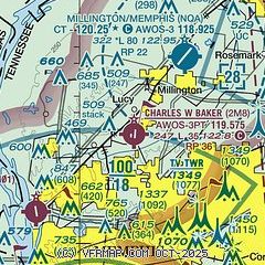
|
| Airport distance calculator |
|---|
|
|
| Sunrise and sunset |
|---|
|
Times for 26-Apr-2026
| | Local
(UTC-5) | | Zulu
(UTC) |
|---|
| Morning civil twilight | | 05:48 | | 10:48 |
| Sunrise | | 06:15 | | 11:15 |
| Sunset | | 19:40 | | 00:40 |
| Evening civil twilight | | 20:07 | | 01:07 |
|
| Current date and time |
|---|
| Zulu (UTC) | 26-Apr-2026 05:39:27 |
|---|
| Local (UTC-5) | 26-Apr-2026 00:39:27 |
|---|
|
| METAR |
|---|
KNQA
5nm NE | 252350Z 26003KT 10SM CLR 26/16 A2978
|
KMEM
13nm S | 260454Z 00000KT 10SM BKN200 BKN250 21/16 A2984 RMK AO2 SLP103 T02060161 $
|
KAWM
17nm SW | 260453Z AUTO 28003KT 10SM CLR 18/17 A2985 RMK AO2 SLP104 T01830172 $
|
KOLV
19nm SE | 260515Z AUTO 00000KT 10SM CLR 18/16 A2984 RMK A01
|
|
| TAF |
|---|
KMEM
13nm S | 252054Z 2521/2624 30006KT P6SM SCT070 FM260000 VRB04KT P6SM SCT045 BKN250 TEMPO 2609/2612 5SM BR FM261500 15008KT P6SM FEW050 BKN250
|
|
| NOTAMs |
|---|
NOTAMs are issued by the DoD/FAA and will open in a separate window not controlled by AirNav.
|
|

