FAA INFORMATION EFFECTIVE 27 NOVEMBER 2025
Location
| FAA Identifier: | 2P7 |
| Lat/Long: | 40-03-24.7071N 080-57-47.4766W
40-03.411785N 080-57.791277W
40.0568631,-80.9631879
(estimated) |
| Elevation: | 1186.5 ft. / 361.6 m (surveyed) |
| Variation: | 08W (2010) |
| From city: | 3 miles SW of ST CLAIRSVILLE, OH |
| Time zone: | UTC -5 (UTC -4 during Daylight Saving Time) |
| Zip code: | 43950 |
Airport Operations
| Airport use: | Open to the public |
| Activation date: | 10/1976 |
| Control tower: | no |
| ARTCC: | CLEVELAND CENTER |
| FSS: | CLEVELAND FLIGHT SERVICE STATION |
| NOTAMs facility: | CLE (NOTAM-D service available) |
| Attendance: | 0800-DUSK |
| Wind indicator: | yes |
| Segmented circle: | no |
| Lights: | ACTVT NSTD LIRL RWY 01/19 - 123.3 OR CALL AMGR. |
| Beacon: | white-green (lighted land airport)
ACTVT ABN - 123.3 OR CALL AMGR. |
| Landing fee: | yes |
Airport Communications
| CTAF: | 122.9 |
| WX AWOS-3 at MPG (15 nm SE): | 119.05 (304-845-2959) |
| WX ASOS at HLG (16 nm NE): | 127.375 (304-277-3504) |
- APCH/DEP SVC PRVDD BY CLEVELAND ARTCC (ZOB) ON FREQS 126.95/239.3 (BELMONT RCAG).
Nearby radio navigation aids
| VOR radial/distance | | VOR name | | Freq | | Var |
|---|
| AIRr297/7.1 | | BELLAIRE VOR/DME | | 117.10 | | 07W |
| HLGr243/21.8 | | WHEELING VOR/DME | | 114.25 | | 07W |
| NDB name | | Hdg/Dist | | Freq | | Var | | ID |
|---|
| CADIZ | | 175/11.0 | | 239 | | 07W | | CFX | -.-. ..-. -..- |
Airport Services
| Parking: | hangars and tiedowns |
| Airframe service: | NONE |
| Powerplant service: | NONE |
| Bottled oxygen: | NONE |
| Bulk oxygen: | NONE |
Runway Information
Runway 1/19
| Dimensions: | 2840 x 50 ft. / 866 x 15 m |
| Surface: | asphalt, in poor condition
SFC IS WEATHERED W/SOME RAVELING, MED BLOCK CRACKING THROUGHOUT |
| Runway edge lights: | non-standard
NSTD LIRL DUE TO 15 FT FM EDGE OF PAVEMENT. |
| Runway edge markings: | FADED.
NSTD BASIC DUE TO SML NRS & SML CNTRLN WITH NSTD SPACING. |
| RUNWAY 1 | | RUNWAY 19 |
| Latitude: | 40-03.178968N | | 40-03.644602N |
| Longitude: | 080-57.819437W | | 080-57.763115W |
| Elevation: | 1160.5 ft. | | 1186.5 ft. |
| Traffic pattern: | left | | left |
| Runway heading: | 013 magnetic, 005 true | | 193 magnetic, 185 true |
| Markings: | NSTD, in poor condition | | NSTD, in poor condition |
| Touchdown point: | yes, no lights | | yes, no lights |
| Obstructions: | 30 ft. trees, 293 ft. from runway, 87 ft. right of centerline, 3:1 slope to clear
+30 FT TREES, 180-200 FT DIST, 120 FT R. | | 61 ft. trees, 339 ft. from runway, 125 ft. right of centerline, 2:1 slope to clear
+25 FT TREE, 175 FT DIST, 0-125 FT R; +10 FT BARN, 180 FT DIST, 120 FT L. |
Airport Ownership and Management from official FAA records
| Ownership: | Privately-owned |
| Owner: | ALDERMAN FAMILY TRUST
67160 AIRPORT RD
SAINT CLAIRSVILLE, OH 43950-9469
Phone 740-695-0908 |
| Manager: | LESLIE ALDERMAN
67160 AIRPORT RD
SAINT CLAIRSVILLE, OH 43950-9469
Phone 740-695-0908 |
Additional Remarks
| - | SOUTH HALF OF RAMP IN POOR COND DUE TO BROKEN PAVEMENT. |
| - | OCNL DEER, BIRDS, & OTR WILDLIFE ON & INVOF ARPT. |
| - | FOR CD CTC CLEVELAND ARTCC AT 440-774-0226/0490. |
Instrument Procedures
NOTE: All procedures below are presented as PDF files. If you need a reader for these files, you should download the free Adobe Reader.NOT FOR NAVIGATION. Please procure official charts for flight.
FAA instrument procedures published for use from 27 November 2025 at 0901Z to 25 December 2025 at 0900Z.
IAPs - Instrument Approach Procedures |
|---|
| VOR-A | |
download (164KB) |
| NOTE: Special Take-Off Minimums/Departure Procedures apply | |
download (164KB) |
Other nearby airports with instrument procedures:
6G5 - Barnesville/Bradfield Airport (11 nm W)
8G6 - Harrison County Airport (11 nm N)
KMPG - Marshall County Airport (15 nm SE)
KHLG - Wheeling Ohio County Airport (16 nm NE)
4G5 - Monroe County Airport (18 nm S)
|
|

Road maps at:
MapQuest
Bing
Google
| Aerial photo |
|---|
WARNING: Photo may not be current or correct
 Photo by Dennis Megarry of MyAirplane.com
Photo taken 19-Oct-2008
Photo by Dennis Megarry of MyAirplane.com
Photo taken 19-Oct-2008
Do you have a better or more recent aerial photo of Alderman Airport that you would like to share? If so, please send us your photo.
|
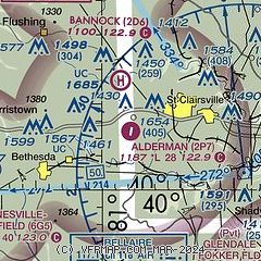
| Sectional chart |
|---|
|
| Airport distance calculator |
|---|
|
|
| Sunrise and sunset |
|---|
|
Times for 24-Dec-2025
| | Local
(UTC-5) | | Zulu
(UTC) |
|---|
| Morning civil twilight | | 07:14 | | 12:14 |
| Sunrise | | 07:45 | | 12:45 |
| Sunset | | 17:02 | | 22:02 |
| Evening civil twilight | | 17:33 | | 22:33 |
|
| Current date and time |
|---|
| Zulu (UTC) | 24-Dec-2025 14:45:05 |
|---|
| Local (UTC-5) | 24-Dec-2025 09:45:05 |
|---|
|
| METAR |
|---|
KHLG
16nm NE | 241403Z 01004KT 9SM SCT016 01/M01 A3035 RMK AO2 T00111011
|
KCDI
29nm W | 241435Z AUTO 00000KT 4SM BR OVC014 00/00 A3039 RMK AO2 T00000000
|
|
| TAF |
|---|
KHLG
16nm NE | 241134Z 2412/2512 28010KT P6SM BKN019 FM241600 00000KT P6SM FEW025 BKN200 FM250800 VRB03KT 6SM -RA OVC015 FM251000 VRB03KT 6SM -RA OVC008
|
|
| NOTAMs |
|---|
NOTAMs are issued by the DoD/FAA and will open in a separate window not controlled by AirNav.
|
|


