FAA INFORMATION EFFECTIVE 19 FEBRUARY 2026
Location
| FAA Identifier: | HLG |
| Lat/Long: | 40-10-30.0410N 080-38-46.5660W
40-10.500683N 080-38.776100W
40.1750114,-80.6462683
(estimated) |
| Elevation: | 1194.3 ft. / 364.0 m (surveyed) |
| Variation: | 07W (1985) |
| From city: | 8 miles NE of WHEELING, WV |
| Time zone: | UTC -5 (UTC -4 during Daylight Saving Time) |
| Zip code: | 26003 |
Airport Operations
| Airport use: | Open to the public |
| Activation date: | 11/1945 |
| Control tower: | yes |
| ARTCC: | CLEVELAND CENTER |
| FSS: | ELKINS FLIGHT SERVICE STATION [703-724-4288] |
| NOTAMs facility: | HLG (NOTAM-D service available) |
| Attendance: | MON-FRI 0700-2200, ALL SAT-SUN 0800-2000 |
| Wind indicator: | lighted |
| Segmented circle: | no |
| Lights: | WHEN ATCT CLSD ACTVT MALSF RWY 03; REIL RWY 21 & 34; PAPI RWY 34; HIRL RWY 03/21; MIRL RWY 16/34; TWY LGTS EXCP TWY A - CTAF. |
| Beacon: | white-green (lighted land airport)
Operates sunset to sunrise. |
Airport Communications
| CTAF: | 118.1 |
| UNICOM: | 122.95 |
| WX ASOS: | 127.375 (304-277-3504) |
| WHEELING GROUND: | 121.75 [0700-2200 MON-FRI; 1000-2000 SAT-SUN] |
| WHEELING TOWER: | 118.1 257.8 [0700-2200 MON-FRI; 1000-2000 SAT-SUN] |
| PITTSBURGH APPROACH: | 125.275 |
| PITTSBURGH DEPARTURE: | 125.275 |
| CLEARANCE DELIVERY: | 125.275 ;WHEN TWR CLSD |
| CLASS B: | 119.35 |
| EMERG: | 121.5 243.0 |
| WX AWOS-3 at 2G2 (11 nm N): | 121.625 (740-275-4862) |
| WX AWOS-3PT at AFJ (16 nm E): | 119.175 (724-228-3529) |
| WX AWOS-3 at MPG (18 nm S): | 119.05 (304-845-2959) |
Nearby radio navigation aids
| VOR radial/distance | | VOR name | | Freq | | Var |
|---|
| HLGr222/6.2 | | WHEELING VOR/DME | | 114.25 | | 07W |
| AIRr047/12.3 | | BELLAIRE VOR/DME | | 117.10 | | 07W |
| AGCr266/28.4 | | ALLEGHENY VOR/DME | | 110.00 | | 09W |
| NDB name | | Hdg/Dist | | Freq | | Var | | ID |
|---|
| CADIZ | | 109/17.2 | | 239 | | 07W | | CFX | -.-. ..-. -..- |
Airport Services
| Fuel available: | 100LL JET-A+ |
| Parking: | hangars and tiedowns |
Runway Information
Runway 3/21
| Dimensions: | 5002 x 150 ft. / 1525 x 46 m |
| Surface: | asphalt/grooved, in fair condition |
| Weight bearing capacity: | | Single wheel: | 120.0 | | Double wheel: | 170.0 | | Double tandem: | 290.0 |
|
| Runway edge lights: | high intensity |
| RUNWAY 3 | | RUNWAY 21 |
| Latitude: | 40-10.113838N | | 40-10.854257N |
| Longitude: | 080-39.078720W | | 080-38.607743W |
| Elevation: | 1170.0 ft. | | 1194.3 ft. |
| Traffic pattern: | left | | left |
| Runway heading: | 033 magnetic, 026 true | | 213 magnetic, 206 true |
| Markings: | precision, in fair condition | | precision, in fair condition |
| Visual slope indicator: | | | 2-box VASI on left (3.00 degrees glide path)
UNUSBL BYD 8 DEGS LEFT OF CNTRLN. |
| RVR equipment: | touchdown, rollout | | touchdown, rollout |
| Approach lights: | MALSF: 1,400 foot medium intensity approach lighting system with sequenced flashers | | |
| Runway end identifier lights: | | | yes |
| Touchdown point: | yes, no lights | | yes, no lights |
| Instrument approach: | ILS | | |
| Obstructions: | 26 ft. trees, 216 ft. from runway, 488 ft. left of centerline
15 FT BRUSH, 0-199 FT DSTC, 370 FT L, 260 FT R. | | none
10 FT BLDG 150 FT DSTC, 250 FT R; 6 FT FENCE, 0-200 FT DSTC, 0-500 FT L/F; 28 FT TREE, 138 FT DSTC, 408 FT L. |
Runway 16/34
| Dimensions: | 4499 x 150 ft. / 1371 x 46 m |
| Surface: | asphalt, in fair condition |
| Weight bearing capacity: | | Single wheel: | 110.0 | | Double wheel: | 143.0 | | Double tandem: | 230.0 |
|
| Runway edge lights: | medium intensity |
| RUNWAY 16 | | RUNWAY 34 |
| Latitude: | 40-10.843270N | | 40-10.195058N |
| Longitude: | 080-38.935395W | | 080-38.467517W |
| Elevation: | 1171.4 ft. | | 1191.0 ft. |
| Traffic pattern: | left | | left |
| Runway heading: | 158 magnetic, 151 true | | 338 magnetic, 331 true |
| Markings: | nonprecision, in fair condition | | nonprecision, in fair condition |
| Visual slope indicator: | | | 4-light PAPI on left (3.00 degrees glide path)
PAPI OTS INDEFLY. |
| Runway end identifier lights: | | | yes
REIL OTS INDFLY. |
| Touchdown point: | yes, no lights | | yes, no lights |
| Obstructions: | none | | 17 ft. trees, 468 ft. from runway, 240 ft. right of centerline, 15:1 slope to clear |
Airport Ownership and Management from official FAA records
| Ownership: | Publicly-owned |
| Owner: | OHIO CO COMSN
1500 CHAPLINE ST
WHEELING, WV 26003
Phone 304-234-3628 |
| Manager: | RUSSEL W. ESCUE
115 SKYWAY LANE
WHEELING, WV 26003
Phone 304-234-3865 |
Additional Remarks
| - | BIRDS AND DEER ON AND INVOF ARPT. |
Instrument Procedures
NOTE: All procedures below are presented as PDF files. If you need a reader for these files, you should download the free Adobe Reader.NOT FOR NAVIGATION. Please procure official charts for flight.
FAA instrument procedures published for use from 19 February 2026 at 0901Z to 19 March 2026 at 0900Z.
IAPs - Instrument Approach Procedures |
|---|
| ILS OR LOC RWY 03 | |
download (287KB) |
| RNAV (GPS) RWY 03 | |
download (243KB) |
| RNAV (GPS) RWY 16 | |
download (207KB) |
| RNAV (GPS) RWY 21 | |
download (209KB) |
| RNAV (GPS) RWY 34 | |
download (216KB) |
| VOR RWY 21 | |
download (186KB) |
| NOTE: Special Alternate Minimums apply | |
download (127KB) |
| NOTE: Special Take-Off Minimums/Departure Procedures apply | |
download (211KB) |
Other nearby airports with instrument procedures:
2G2 - Geary A Bates/Jefferson County Airpark (11 nm N)
2P7 - Alderman Airport (16 nm SW)
KAFJ - Washington County Airport (16 nm E)
8G6 - Harrison County Airport (17 nm W)
KMPG - Marshall County Airport (18 nm S)
|
|

Road maps at:
MapQuest
Bing
Google
| Aerial photo |
|---|
WARNING: Photo may not be current or correct
 Photo by Trey Buttriss
Photo taken 10-Apr-2004
Photo by Trey Buttriss
Photo taken 10-Apr-2004
Do you have a better or more recent aerial photo of Wheeling Ohio County Airport that you would like to share? If so, please send us your photo.
|
| Sectional chart |
|---|
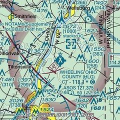
|
 Download PDF
of official airport diagram from the FAA
| Airport distance calculator |
|---|
|
|
| Sunrise and sunset |
|---|
|
Times for 17-Mar-2026
| | Local
(UTC-4) | | Zulu
(UTC) |
|---|
| Morning civil twilight | | 07:05 | | 11:05 |
| Sunrise | | 07:32 | | 11:32 |
| Sunset | | 19:30 | | 23:30 |
| Evening civil twilight | | 19:57 | | 23:57 |
|
| Current date and time |
|---|
| Zulu (UTC) | 17-Mar-2026 07:10:25 |
|---|
| Local (UTC-4) | 17-Mar-2026 03:10:25 |
|---|
|
| METAR |
|---|
| KHLG | 170653Z AUTO 26015G27KT 10SM OVC034 M05/M09 A2977 RMK AO2 PK WND 27035/0622 SLP096 T10501094
|
KAFJ
18nm E | 170656Z AUTO 27017G26KT 6SM -SN OVC034 M05/M09 A2979 RMK AO2 PK WND 28030/0642 SNB00 SLP099 P0000 T10501089 FZRANO $
|
|
| TAF |
|---|
| KHLG | 170520Z 1706/1806 26015G25KT 6SM -SHSN SCT008 BKN025 FM170800 26013G21KT P6SM BKN025 FM171500 27014G24KT 5SM -SHSN BKN035 PROB30 1716/1721 1SM -SHSN BKN020 FM172100 27012G20KT 6SM -SHSN BKN040 FM180100 26006KT P6SM SCT040 BKN250
|
|
| NOTAMs |
|---|
NOTAMs are issued by the DoD/FAA and will open in a separate window not controlled by AirNav.
|
|


