FAA INFORMATION EFFECTIVE 14 MAY 2026
Location
| FAA Identifier: | 8G6 |
| Lat/Long: | 40-14-18.1330N 081-00-46.3820W
40-14.302217N 081-00.773033W
40.2383703,-81.0128839
(estimated) |
| Elevation: | 1176.2 ft. / 358.5 m (surveyed) |
| Variation: | 08W (2000) |
| From city: | 2 miles S of CADIZ, OH |
| Time zone: | UTC -4 (UTC -5 during Standard Time) |
| Zip code: | 43907 |
Airport Operations
| Airport use: | Open to the public |
| Activation date: | 11/1960 |
| Control tower: | no |
| ARTCC: | CLEVELAND CENTER |
| FSS: | CLEVELAND FLIGHT SERVICE STATION |
| NOTAMs facility: | CLE (NOTAM-D service available) |
| Attendance: | MON-SAT 0900-1700 |
| Wind indicator: | lighted |
| Segmented circle: | no |
| Lights: | ACTVT PAPI RWY 13 & 31; MIRL RWY 13/31 - CTAF. |
| Beacon: | white-green (lighted land airport)
Operates sunset to sunrise. |
Airport Communications
| CTAF/UNICOM: | 122.8 |
| WX AWOS-3 at 2G2 (16 nm NE): | 121.625 (740-275-4862) |
| WX ASOS at HLG (17 nm E): | 127.375 (304-277-3504) |
- APCH/DEP SVC PRVDD BY CLEVELAND ARTCC (ZOB) ON FREQS 126.95/239.3 (BELMONT RCAG).
Nearby radio navigation aids
| VOR radial/distance | | VOR name | | Freq | | Var |
|---|
| AIRr333/16.0 | | BELLAIRE VOR/DME | | 117.10 | | 07W |
| HLGr273/20.4 | | WHEELING VOR/DME | | 114.25 | | 07W |
| BSVr152/35.7 | | BRIGGS VOR/DME | | 114.05 | | 04W |
| NDB name | | Hdg/Dist | | Freq | | Var | | ID |
|---|
| CADIZ | | at field | | 239 | | 07W | | CFX | -.-. ..-. -..- |
Airport Services
| Fuel available: | 100LL |
| Parking: | hangars |
| Airframe service: | NONE
PAINT SHOP ON FLD CALL AMGR. |
| Powerplant service: | NONE |
| Bottled oxygen: | NONE |
| Bulk oxygen: | NONE |
Runway Information
Runway 13/31
| Dimensions: | 4154 x 60 ft. / 1266 x 18 m |
| Surface: | asphalt, in good condition |
| Weight bearing capacity: | |
| Runway edge lights: | medium intensity |
| RUNWAY 13 | | RUNWAY 31 |
| Latitude: | 40-14.504967N | | 40-14.099460N |
| Longitude: | 081-01.132543W | | 081-00.413548W |
| Elevation: | 1176.2 ft. | | 1105.5 ft. |
| Traffic pattern: | right | | left |
| Runway heading: | 134 magnetic, 126 true | | 314 magnetic, 306 true |
| Displaced threshold: | 874 ft. | | 410 ft. |
| Markings: | nonprecision, in fair condition | | nonprecision, in fair condition |
| Visual slope indicator: | 2-light PAPI on left (4.00 degrees glide path) | | 2-light PAPI on left (4.00 degrees glide path) |
| Runway end identifier lights: | no | | no |
| Touchdown point: | yes, no lights | | yes, no lights |
| Obstructions: | 40 ft. hill, 201 ft. from runway, 118 ft. left and right of centerline
0-40 FT HILL, 0-200 FT DIST, 100 FT L TO 140 FT R. | | 44 ft. trees, 435 ft. from runway, 238 ft. right of centerline, 5:1 slope to clear
6 FT MOUND, 115-200 FT DIST, 165-250 FT L. |
Airport Ownership and Management from official FAA records
| Ownership: | Publicly-owned |
| Owner: | HARRISON CO ARPT AUTH
43000 AIRPORT RD
CADIZ, OH 43907-9605
Phone 740-942-2316 |
| Manager: | MARK MILLER
43000 AIRPORT RD
CADIZ, OH 43907-9605
Phone 740-491-2815 |
Additional Remarks
| - | FOR CD CTC CLEVELAND ARTCC AT 440-774-0226/0490. |
| - | DEER ON & INVOF ARPT. |
Instrument Procedures
NOTE: All procedures below are presented as PDF files. If you need a reader for these files, you should download the free Adobe Reader.NOT FOR NAVIGATION. Please procure official charts for flight.
FAA instrument procedures published for use from 14 May 2026 at 0901Z to 11 June 2026 at 0900Z.
IAPs - Instrument Approach Procedures |
|---|
| RNAV (GPS) RWY 13 | |
download (188KB) |
| RNAV (GPS) RWY 31 | |
download (195KB) |
| NOTE: Special Take-Off Minimums/Departure Procedures apply | |
download (406KB) |
Other nearby airports with instrument procedures:
2P7 - Alderman Airport (11 nm S)
2G2 - Geary A Bates/Jefferson County Airpark (16 nm NE)
6G5 - Barnesville/Bradfield Airport (16 nm SW)
KHLG - Wheeling Ohio County Airport (17 nm E)
KTSO - Carroll County/Tolson Airport (20 nm N)
|
|

Road maps at:
MapQuest
Bing
Google
| Aerial photo |
|---|
WARNING: Photo may not be current or correct

Do you have a better or more recent aerial photo of Harrison County Airport that you would like to share? If so, please send us your photo.
|
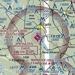
| Sectional chart |
|---|
|
| Airport distance calculator |
|---|
|
|
| Sunrise and sunset |
|---|
|
Times for 21-May-2026
| | Local
(UTC-4) | | Zulu
(UTC) |
|---|
| Morning civil twilight | | 05:33 | | 09:33 |
| Sunrise | | 06:04 | | 10:04 |
| Sunset | | 20:37 | | 00:37 |
| Evening civil twilight | | 21:09 | | 01:09 |
|
| Current date and time |
|---|
| Zulu (UTC) | 21-May-2026 19:54:02 |
|---|
| Local (UTC-4) | 21-May-2026 15:54:02 |
|---|
|
| METAR |
|---|
KHLG
17nm E | 211853Z 05008KT 10SM CLR 16/10 A3020 RMK AO2 SLP230 T01610100
|
KPHD
23nm NW | 211853Z AUTO 06007KT 10SM CLR 18/06 A3022 RMK AO2 SLP234 T01780061
|
KCDI
30nm SW | 211935Z AUTO 36006KT 10SM CLR 18/11 A3020 RMK AO2 T01830107
|
|
| TAF |
|---|
KHLG
17nm E | 211720Z 2118/2218 05010KT P6SM BKN040 FM220000 06008KT P6SM SCT050 FM221100 08010KT P6SM BKN025
|
|
| NOTAMs |
|---|
NOTAMs are issued by the DoD/FAA and will open in a separate window not controlled by AirNav.
|
|


