FAA INFORMATION EFFECTIVE 09 JULY 2026
Location
| FAA Identifier: | PHD |
| Lat/Long: | 40-28-12.6000N 081-25-11.8000W
40-28.210000N 081-25.196667W
40.4701667,-81.4199444
(estimated) |
| Elevation: | 894.4 ft. / 272.6 m (surveyed) |
| Variation: | 08W (2000) |
| From city: | 2 miles SE of NEW PHILADELPHIA, OH |
| Time zone: | UTC -4 (UTC -5 during Standard Time) |
| Zip code: | 44663 |
Airport Operations
| Airport use: | Open to the public |
| Activation date: | 03/1940 |
| Control tower: | no |
| ARTCC: | CLEVELAND CENTER |
| FSS: | CLEVELAND FLIGHT SERVICE STATION |
| NOTAMs facility: | PHD (NOTAM-D service available) |
| Attendance: | MON-FRI 0730-1700
CLSD MAJOR HOLS; FOR SVC AFT HRS CALL AMGR CELL. |
| Wind indicator: | lighted |
| Segmented circle: | no |
| Lights: | ACTVT REIL RWY 15 & 33; MIRL RWY 15/33 - 123.3. PAPI RWY 15 & 33 OPR CONSLY. |
| Beacon: | white-green (lighted land airport)
Operates sunset to sunrise. |
Airport Communications
| CTAF/UNICOM: | 122.8 |
| WX ASOS: | 121.425 (330-339-1125) |
| CLEVELAND APPROACH: | 125.5 |
| CLEVELAND DEPARTURE: | 125.5 |
- APCH/DEP SVC PRVDD BY CLEVELAND APCH (CLE) 0600-0100. APCH/DEP SVC PRVDD BY CLEVELAND ARTCC (ZOB) ON FREQS 120.6/379.275 (MOUNT HOPE RCAG) 0100-0600.
Nearby radio navigation aids
| VOR radial/distance | | VOR name | | Freq | | Var |
|---|
| BSVr182/16.2 | | BRIGGS VOR/DME | | 114.05 | | 04W |
| AIRr322/38.7 | | BELLAIRE VOR/DME | | 117.10 | | 07W |
| ACOr199/39.5 | | AKRON VOR/DME | | 114.40 | | 04W |
| NDB name | | Hdg/Dist | | Freq | | Var | | ID |
|---|
| CADIZ | | 314/23.3 | | 239 | | 07W | | CFX | -.-. ..-. -..- |
Airport Services
| Fuel available: | 100LL JET-A |
| Parking: | hangars and tiedowns |
| Airframe service: | MAJOR |
| Powerplant service: | MAJOR |
| Bottled oxygen: | NONE |
| Bulk oxygen: | NONE |
Runway Information
Runway 15/33
| Dimensions: | 3951 x 100 ft. / 1204 x 30 m |
| Surface: | asphalt, in good condition |
| Weight bearing capacity: | | Single wheel: | 52.5 | | Double wheel: | 67.5 | | Double tandem: | 140.0 |
|
| Runway edge lights: | medium intensity |
| RUNWAY 15 | | RUNWAY 33 |
| Latitude: | 40-28.500858N | | 40-28.007618N |
| Longitude: | 081-25.462670W | | 081-24.907118W |
| Elevation: | 894.4 ft. | | 886.1 ft. |
| Traffic pattern: | left | | left |
| Runway heading: | 147 magnetic, 139 true | | 327 magnetic, 319 true |
| Displaced threshold: | 330 ft. | | no |
| Declared distances: | TORA:3951 TODA:3951 ASDA:3951 LDA:3621 | | TORA:3951 TODA:3951 ASDA:3634 LDA:3634 |
| Markings: | nonprecision, in fair condition | | nonprecision, in fair condition |
| Visual slope indicator: | 4-light PAPI on right (4.00 degrees glide path) | | 4-light PAPI on left (4.00 degrees glide path)
PAPI UNUSBL BYD 5 DEGS LEFT OF CNTRLN. |
| Runway end identifier lights: | yes | | yes |
| Touchdown point: | yes, no lights | | yes, no lights |
| Obstructions: | 15 ft. road, 200 ft. from runway, 9 ft. right of centerline
+15 FT ROAD, 0-200 FT DIST, 7-115 FT R; +7 FT FENCE, 0-200 FT DIST, 15 FT L TO 90 FT R; +16 FT BLDG, 168 FT DIST, 237 FT L. | | 46 ft. trees, 401 ft. from runway, 170 ft. right of centerline, 4:1 slope to clear
+18-25 TREES, 0-100 FT DIST, 230 FT L. |
Runway 12/30
| Dimensions: | 1907 x 70 ft. / 581 x 21 m |
| Surface: | turf, in good condition |
| Runway edge markings: | YELLOW CONES. |
| RUNWAY 12 | | RUNWAY 30 |
| Latitude: | 40-28.166893N | | 40-28.067007N |
| Longitude: | 081-25.415647W | | 081-25.025773W |
| Elevation: | 890.4 ft. | | 885.9 ft. |
| Traffic pattern: | left | | left |
| Runway heading: | 117 magnetic, 109 true | | 297 magnetic, 289 true |
| Declared distances: | TORA:1907 TODA:1907 ASDA:1907 LDA:1758 | | TORA:1907 TODA:1907 ASDA:1758 LDA:1758 |
| Markings: | , in good condition | | , in good condition |
| Runway end identifier lights: | no | | no |
| Touchdown point: | yes, no lights | | yes, no lights |
| Obstructions: | 70 ft. trees, 428 ft. from runway, 80 ft. right of centerline, 6:1 slope to clear | | 81 ft. trees, 593 ft. from runway, 170 ft. right of centerline, 7:1 slope to clear |
Airport Ownership and Management from official FAA records
| Ownership: | Publicly-owned |
| Owner: | CITY OF NEW PHILADELPHIA
SERVICE DIRECTOR, 150 E HIGH AVE STE 200
NEW PHILADELPHIA, OH 44663-4500
Phone 330-364-4491 |
| Manager: | ERIC HUBBARD
1834 E HIGH AVE
NEW PHILADELPHIA, OH 44663-3239
Phone 330-339-6078
CELL 330-827-0820. |
Additional Remarks
| - | TWY A CLSD WHEN ACFT ON APCH OR DEP; SFC MKG CONFLICT. |
| - | FOR CD CTC CLEVELAND APCH AT 216-352-2323, WHEN APCH CLSD CTC CLEVELAND ARTCC AT 440-774-0223/0490. |
Instrument Procedures
NOTE: All procedures below are presented as PDF files. If you need a reader for these files, you should download the free Adobe Reader.NOT FOR NAVIGATION. Please procure official charts for flight.
FAA instrument procedures published for use from 09 July 2026 at 0901Z to 06 August 2026 at 0900Z.
IAPs - Instrument Approach Procedures |
|---|
| RNAV (GPS) RWY 15 | |
download (166KB) |
| RNAV (GPS) RWY 33 | |
download (181KB) |
| VOR-A | |
download (185KB) |
| NOTE: Special Alternate Minimums apply | |
download (146KB) |
| NOTE: Special Take-Off Minimums/Departure Procedures apply | |
download (467KB) |
Other nearby airports with instrument procedures:
KTSO - Carroll County/Tolson Airport (17 nm E)
I40 - Richard Downing Airport (22 nm SW)
8G6 - Harrison County Airport (23 nm SE)
10G - Holmes County Airport (25 nm W)
KCAK - Akron-Canton Regional Airport (27 nm N)
|
|

Road maps at:
MapQuest
Bing
Google
| Aerial photo |
|---|
WARNING: Photo may not be current or correct
 Photo by M.L. Caldwell, III
Photo taken 22-Oct-2018
looking northeast.
Photo by M.L. Caldwell, III
Photo taken 22-Oct-2018
looking northeast.
Do you have a better or more recent aerial photo of Harry Clever Field Airport that you would like to share? If so, please send us your photo.
|
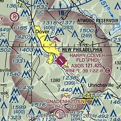
| Sectional chart |
|---|
|
| Airport distance calculator |
|---|
|
|
| Sunrise and sunset |
|---|
|
Times for 16-Jul-2026
| | Local
(UTC-4) | | Zulu
(UTC) |
|---|
| Morning civil twilight | | 05:38 | | 09:38 |
| Sunrise | | 06:10 | | 10:10 |
| Sunset | | 20:54 | | 00:54 |
| Evening civil twilight | | 21:26 | | 01:26 |
|
| Current date and time |
|---|
| Zulu (UTC) | 16-Jul-2026 22:41:15 |
|---|
| Local (UTC-4) | 16-Jul-2026 18:41:15 |
|---|
|
| METAR |
|---|
| KPHD | 162153Z AUTO 36006KT 3/4SM HZ BKN023 OVC032 29/23 A3002 RMK AO2 SLP159 T02940228
|
|
| TAF |
|---|
KCAK
27nm N | 161722Z 1618/1718 33006KT 1SM FU BKN250 FM162100 VRB04KT 3SM HZ SCT250
|
|
| NOTAMs |
|---|
NOTAMs are issued by the DoD/FAA and will open in a separate window not controlled by AirNav.
|
|


