FAA INFORMATION EFFECTIVE 19 MARCH 2026
Location
| FAA Identifier: | 35D |
| Lat/Long: | 42-31-49.5715N 085-49-25.6044W
42-31.826192N 085-49.426740W
42.5304365,-85.8237790
(estimated) |
| Elevation: | 706 ft. / 215.2 m (surveyed) |
| Variation: | 05W (2010) |
| From city: | 1 mile E of ALLEGAN, MI |
| Time zone: | UTC -4 (UTC -5 during Standard Time) |
| Zip code: | 49010 |
Airport Operations
| Airport use: | Open to the public |
| Activation date: | 04/1940 |
| Control tower: | no |
| ARTCC: | CHICAGO CENTER |
| FSS: | LANSING FLIGHT SERVICE STATION |
| NOTAMs facility: | LAN (NOTAM-D service available) |
| Attendance: | UNATNDD |
| Wind indicator: | lighted |
| Segmented circle: | yes |
| Lights: | ACTVT REIL RWY 11 & 29; PAPI RWY 11 & 29; MIRL RWY 11/29 - CTAF. |
| Beacon: | white-green (lighted land airport)
Operates sunset to sunrise. |
Airport Communications
| CTAF/UNICOM: | 122.8 |
| GREAT LAKES APPROACH: | 128.4 |
| GREAT LAKES DEPARTURE: | 128.4 |
| WX ASOS at BIV (18 nm NW): | 119.025 (616-394-0190) |
- APCH/DEP SVC PRVDD BY CHICAGO ARTCC (ZAU) ON FREQS 128.5/273.525 (PULLMAN RCAG) WHEN GREAT LAKES APCH CTL CLSD.
Nearby radio navigation aids
| VOR radial/distance | | VOR name | | Freq | | Var |
|---|
| PMMr073/13.0 | | PULLMAN VOR/DME | | 112.10 | | 00E |
| VIOr227/21.1 | | VICTORY VOR/DME | | 115.95 | | 04W |
Airport Services
| Fuel available: | 100LL
100LL:SELF SVC. |
| Parking: | tiedowns |
| Airframe service: | NONE |
| Powerplant service: | NONE |
Runway Information
Runway 11/29
| Dimensions: | 4300 x 75 ft. / 1311 x 23 m |
| Surface: | asphalt, in good condition |
| Weight bearing capacity: | |
| Runway edge lights: | medium intensity |
| RUNWAY 11 | | RUNWAY 29 |
| Latitude: | 42-31.851855N | | 42-31.757258N |
| Longitude: | 085-49.832170W | | 085-48.883543W |
| Elevation: | 703.6 ft. | | 702.7 ft. |
| Traffic pattern: | left | | left |
| Runway heading: | 103 magnetic, 098 true | | 283 magnetic, 278 true |
| Markings: | nonprecision, in fair condition | | nonprecision, in fair condition |
| Visual slope indicator: | 4-light PAPI on left (3.00 degrees glide path) | | 4-light PAPI on left (3.00 degrees glide path)
PAPI UNUSBL BYD 9 DEGS LEFT OF CNTRLN. |
| Runway end identifier lights: | yes | | yes |
| Touchdown point: | yes, no lights | | yes, no lights |
| Obstructions: | none | | 21 ft. tree, 403 ft. from runway, 267 ft. left of centerline, 9:1 slope to clear |
Runway 15/33
| Dimensions: | 1830 x 150 ft. / 558 x 46 m |
| Surface: | turf, in fair condition |
| Operational restrictions: | CLSD NOV 15 THRU MAR & WHEN SNOW COVD. |
| RUNWAY 15 | | RUNWAY 33 |
| Latitude: | 42-31.993555N | | 42-31.760500N |
| Longitude: | 085-49.717692W | | 085-49.459500W |
| Elevation: | 700.0 ft. | | 703.6 ft. |
| Traffic pattern: | left | | left |
| Runway heading: | 146 magnetic, 141 true | | 326 magnetic, 321 true |
| Displaced threshold: | 530 ft. | | no |
| Runway end identifier lights: | no | | no |
| Touchdown point: | yes, no lights | | yes, no lights |
| Obstructions: | 96 ft. tree, 1175 ft. from runway, 10 ft. right of centerline, 12:1 slope to clear | | 6 ft. tree, 125 ft. left of centerline, 1:1 slope to clear |
Airport Ownership and Management from official FAA records
| Ownership: | Publicly-owned |
| Owner: | CITY OF ALLEGAN
231 TROWBRIDGE ST
ALLEGAN, MI 49010-1306
Phone 269-673-5511 |
| Manager: | DOUG KADZBAN
231 TROWBRIDGE ST
ALLEGAN, MI 49010-1306
Phone 269-686-1115
CELL 616-430-0324. |
Additional Remarks
| - | ADMIN BLDG ACCESS, PRESS 5-3-2-1. |
| - | SKYDIVING ACTIVITY THU - SUN. |
| - | FOR CD CTC GREAT LAKES APCH AT 269-459-3344, WHEN APCH CLSD CTC CHICAGO ARTCC AT 630-906-8921. |
| - | RWY CONDS UNMON CTC AMGR FOR DTLS. |
Instrument Procedures
NOTE: All procedures below are presented as PDF files. If you need a reader for these files, you should download the free Adobe Reader.NOT FOR NAVIGATION. Please procure official charts for flight.
FAA instrument procedures published for use from 19 March 2026 at 0901Z to 16 April 2026 at 0900Z.
IAPs - Instrument Approach Procedures |
|---|
| RNAV (GPS) RWY 11 **CHANGED** | |
download (224KB) |
| RNAV (GPS) RWY 29 **CHANGED** | |
download (229KB) |
| NOTE: Special Take-Off Minimums/Departure Procedures apply | |
download (328KB) |
Other nearby airports with instrument procedures:
Z98 - Ottawa Executive Airport (18 nm N)
KBIV - West Michigan Regional Airport (18 nm NW)
KAZO - Kalamazoo/Battle Creek International Airport (21 nm SE)
KLWA - South Haven Area Regional Airport (22 nm SW)
9D9 - Hastings Airport (23 nm E)
|
|

Road maps at:
MapQuest
Bing
Google
| Aerial photo |
|---|
WARNING: Photo may not be current or correct
 Photo by Gerald Doutt
Photo taken 03-Nov-2013
looking northwest.
Photo by Gerald Doutt
Photo taken 03-Nov-2013
looking northwest.
Do you have a better or more recent aerial photo of Padgham Field Airport that you would like to share? If so, please send us your photo.
|
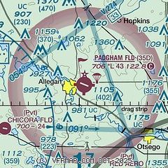
| Sectional chart |
|---|
|
| Airport distance calculator |
|---|
|
|
| Sunrise and sunset |
|---|
|
Times for 02-Apr-2026
| | Local
(UTC-4) | | Zulu
(UTC) |
|---|
| Morning civil twilight | | 06:56 | | 10:56 |
| Sunrise | | 07:25 | | 11:25 |
| Sunset | | 20:09 | | 00:09 |
| Evening civil twilight | | 20:37 | | 00:37 |
|
| Current date and time |
|---|
| Zulu (UTC) | 03-Apr-2026 03:58:20 |
|---|
| Local (UTC-4) | 02-Apr-2026 23:58:20 |
|---|
|
| METAR |
|---|
KBIV
18nm NW | 030353Z AUTO 21017G28KT 10SM VCTS -RA BKN070 BKN090 OVC110 16/13 A2970 RMK AO2 PK WND 21040/0304 LTG DSNT E-SW RAB14 SLP038 P0001 T01610128
|
KAZO
22nm SE | 030353Z AUTO 19017G26KT 10SM FEW046 SCT080 BKN095 17/14 A2976 RMK AO2 PK WND 19026/0348 LTG DSNT NW SLP079 T01720144
|
KLWA
22nm SW | 030335Z AUTO 23021G26KT 10SM FEW016 OVC024 18/14 A2977 RMK AO2 PK WND 25029/58 PRESRR
|
KGRR
25nm NE | 030353Z 21018G35KT 10SM -RA FEW035 SCT060 OVC100 18/14 A2973 RMK AO2 PK WND 21035/0349 RAB26 SLP069 OCNL LTGIC DSNT SW CB DSNT SW MOV NE LAST T01780144 PNO
|
KBTL
29nm SE | 030353Z AUTO 20017G25KT 10SM BKN047 17/14 A2977 RMK AO2 PK WND 18029/0341 SLP082 T01720144
|
KBEH
35nm SW | 030353Z AUTO 22010KT 10SM VCTS BKN027 BKN038 OVC046 18/14 A2972 RMK AO2 PK WND 27034/0326 WSHFT 0319 LTG DSNT ALQDS RAB33E41 SLP065 P0000 T01780139
|
KHAI
36nm S | 030335Z AUTO 19015G23KT 10SM SCT048 SCT050 18/15 A2977 RMK AO2 PK WND 19026/17
|
|
| TAF |
|---|
KAZO
22nm SE | 030048Z 0301/0324 20016G26KT 6SM -SHRA BR VCTS BKN050CB WS020/21050KT FM030400 20016G28KT P6SM VCSH BKN050 WS020/21050KT FM030500 20016G28KT P6SM -SHRA BKN040 WS020/22050KT FM030900 25012G24KT P6SM BKN018 FM031600 27008KT P6SM BKN027
|
KGRR
25nm NE | 030046Z 0301/0324 17013G23KT 6SM BR VCTS BKN090CB OVC110CB WS020/21045KT FM030200 19016G28KT P6SM -SHRA VCTS BKN035CB WS020/21050KT FM030500 21017G28KT P6SM -SHRA BKN030 WS020/22050KT FM030700 23016G28KT P6SM VCSH BKN019 WS020/23045KT FM031200 27011G19KT P6SM BKN008 FM032200 31005KT P6SM SCT230
|
|
| NOTAMs |
|---|
NOTAMs are issued by the DoD/FAA and will open in a separate window not controlled by AirNav.
|
|

