FAA INFORMATION EFFECTIVE 17 APRIL 2025
Location
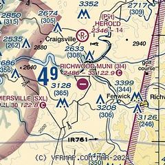
| FAA Identifier: | 3I4 |
| Lat/Long: | 38-15-30.2000N 080-39-04.8000W
38-15.503333N 080-39.080000W
38.2583889,-80.6513333
(estimated) |
| Elevation: | 2486 ft. / 757.7 m (surveyed) |
| Variation: | 06W (1985) |
| From city: | 6 miles W of RICHWOOD, WV |
| Time zone: | UTC -4 (UTC -5 during Standard Time) |
| Zip code: | 26202 |
Airport Operations
| Airport use: | Open to the public |
| Activation date: | 01/1960 |
| Control tower: | no |
| ARTCC: | WASHINGTON CENTER |
| FSS: | ELKINS FLIGHT SERVICE STATION [703-724-4288] |
| NOTAMs facility: | EKN (NOTAM-D service available) |
| Attendance: | UNATNDD |
| Wind indicator: | yes |
| Segmented circle: | no |
Airport Communications
Airport Services
| Parking: | tiedowns |
| Bottled oxygen: | NONE |
| Bulk oxygen: | NONE |
Runway Information
Runway 10/28
| Dimensions: | 3360 x 60 ft. / 1024 x 18 m |
| Surface: | asphalt, in poor condition
PAVEMENT CRACKS WITH VEGETATION.
SOFT SHOULDERS. |
| RUNWAY 10 | | RUNWAY 28 |
| Latitude: | 38-15.531975N | | 38-15.473707N |
| Longitude: | 080-39.428585W | | 080-38.730232W |
| Elevation: | 2416.0 ft. | | 2486.0 ft. |
| Traffic pattern: | left | | left |
| Runway heading: | 102 magnetic, 096 true | | 282 magnetic, 276 true |
| Markings: | , in fair condition | | basic, in fair condition |
| Obstructions: | 18 ft. trees, 222 ft. from runway, 60 ft. right of centerline, 1:1 slope to clear
40 FT TREES, UP TO 199 FT DSTC. | | 70 ft. trees, 275 ft. from runway, 140 ft. left and right of centerline, 1:1 slope to clear
10 FT GND & 50 FT TREES; 30 TO 199 FT DSTC. |
Airport Ownership and Management from official FAA records
| Ownership: | Publicly-owned |
| Owner: | CITY OF RICHWOOD
6 WHITE AVE
RICHWOOD, WV 26261
Phone 304-846-2596
GARY JOHNSON, MAYOR 304-562-4379; GARYJONHSONMAYOR@GMAIL.COM. |
| Manager: | BOB JOHNSON
RICHWOOD AIRPORT AUTHORITY, 6 WHITE AVE
RICHWOOD, WV 26261
Phone 304-618-3611 |
Additional Remarks
| - | RWY 10/28 NO SNOW REMOVAL. RWY FREQUENTLY SNOW COVERED WINTER MONTHS. |
| - | DEER & BIRDS ON & INVOF ARPT. |
| - | ARPT CLSD NIGHTS. |
| - | ARPT PHYS. ADDR. 3437 AIRPORT RD. RICHWOOD, WV. |
| - | FOR CD CTC WASHINGTON ARTCC AT 703-771-3587. |
| - | ARPT GATE LOCKED. CALL AMGR FOR ACCESS. |
Instrument Procedures
There are no published instrument procedures at 3I4.
Some nearby airports with instrument procedures:
KSXL - Summersville Airport (10 nm W)
48I - Braxton County Airport (26 nm N)
KLWB - Greenbrier Valley Airport (27 nm SE)
KBKW - Raleigh County Memorial Airport (36 nm SW)
KHSP - Ingalls Field Airport (43 nm SE)
|
|

Road maps at:
MapQuest
Bing
Google
| Aerial photo |
|---|
WARNING: Photo may not be current or correct
 Photo taken 23-May-2009
looking northeast.
Photo taken 23-May-2009
looking northeast.
Do you have a better or more recent aerial photo of Richwood Municipal Airport that you would like to share? If so, please send us your photo.
|
| Sectional chart |
|---|
|
| Airport distance calculator |
|---|
|
|
| Sunrise and sunset |
|---|
|
Times for 18-Apr-2025
| | Local
(UTC-4) | | Zulu
(UTC) |
|---|
| Morning civil twilight | | 06:16 | | 10:16 |
| Sunrise | | 06:44 | | 10:44 |
| Sunset | | 20:00 | | 00:00 |
| Evening civil twilight | | 20:28 | | 00:28 |
|
| Current date and time |
|---|
| Zulu (UTC) | 18-Apr-2025 07:10:45 |
|---|
| Local (UTC-4) | 18-Apr-2025 03:10:45 |
|---|
|
| METAR |
|---|
K48I
26nm N | 180655Z AUTO 00000KT 10SM BKN110 08/03 A3011 RMK AO2 T00820032
|
KLWB
26nm SE | 180655Z AUTO 00000KT 10SM BKN120 10/02 A3018 RMK AO2 T01040024
|
KBKW
35nm SW | 180551Z AUTO 14011KT 10SM CLR 13/M01 A3015 RMK AO2 SLP196 T01331006 10172 20133 56002
|
KHSP
44nm SE | 180655Z AUTO 17007KT 10SM SCT110 10/M02 A3021 RMK AO2 T01001020
|
KCRW
45nm W | 180654Z 00000KT 10SM FEW110 12/01 A3008 RMK AO2 SLP182 T01170011 $
|
KW22
48nm N | 180655Z AUTO 12003KT 10SM SCT026 OVC120 12/M05 A3011 RMK AO2
|
|
| TAF |
|---|
KLWB
26nm SE | 180520Z 1806/1906 19004KT P6SM SCT240 FM181700 20008G18KT P6SM SCT250 FM190400 23003KT P6SM FEW250 WS005/25025KT
|
|
| NOTAMs |
|---|
NOTAMs are issued by the DoD/FAA and will open in a separate window not controlled by AirNav.
|
|


