FAA INFORMATION EFFECTIVE 11 JUNE 2026
Location
| FAA Identifier: | 3M7 |
| Lat/Long: | 36-31-12.1000N 086-03-29.0000W
36-31.201667N 086-03.483333W
36.5200278,-86.0580556
(estimated) |
| Elevation: | 969 ft. / 295.4 m (surveyed) |
| Variation: | 02W (1990) |
| From city: | 2 miles W of LAFAYETTE, TN |
| Time zone: | UTC -5 (UTC -6 during Standard Time) |
| Zip code: | 37083 |
Airport Operations
| Airport use: | Open to the public |
| Control tower: | no |
| ARTCC: | MEMPHIS CENTER |
| FSS: | NASHVILLE FLIGHT SERVICE STATION |
| NOTAMs facility: | BNA (NOTAM-D service available) |
| Attendance: | MON-FRI 0830-1500, ALL SAT 0830-1200 |
| Wind indicator: | lighted |
| Segmented circle: | yes |
| Lights: | SS-SR |
| Beacon: | white-green (lighted land airport)
Operates sunset to sunrise. |
Airport Communications
| CTAF/UNICOM: | 122.8 |
| NASHVILLE APPROACH: | 118.4 |
| NASHVILLE DEPARTURE: | 118.4 |
| WX AWOS-3 at XNX (19 nm SW): | 132.725 (615-230-8005) |
Nearby radio navigation aids
| VOR radial/distance | | VOR name | | Freq | | Var |
|---|
| BNAr055/38.0 | | NASHVILLE VORTAC | | 114.10 | | 02W |
| NDB name | | Hdg/Dist | | Freq | | Var | | ID |
|---|
| HUCHN | | 327/39.2 | | 233 | | 03W | | HEM | .... . -- |
Airport Services
| Fuel available: | 100LL JET-A+
100LL:CREDIT CARD SVC H24 AVBL. |
| Parking: | tiedowns |
| Airframe service: | MINOR |
| Powerplant service: | MINOR |
Runway Information
Runway 1/19
| Dimensions: | 5200 x 75 ft. / 1585 x 23 m |
| Surface: | asphalt, in excellent condition |
| Weight bearing capacity: | | PCN 11 /F/C/X/T | | Single wheel: | 31.0 | | Double wheel: | 47.0 |
|
| Runway edge lights: | medium intensity |
| RUNWAY 1 | | RUNWAY 19 |
| Latitude: | 36-30.775500N | | 36-31.627500N |
| Longitude: | 086-03.541333W | | 086-03.424500W |
| Elevation: | 969.0 ft. | | 945.4 ft. |
| Traffic pattern: | left | | left |
| Runway heading: | 008 magnetic, 006 true | | 188 magnetic, 186 true |
| Displaced threshold: | 200 ft. | | no |
| Declared distances: | TORA:5200 TODA:5200 ASDA:5200 LDA:5000 | | TORA:5200 TODA:5200 ASDA:5000 LDA:5000 |
| Markings: | basic, in good condition | | basic, in good condition |
| Visual slope indicator: | 2-light PAPI on left (3.50 degrees glide path) | | 2-light PAPI on left (3.00 degrees glide path) |
| Runway end identifier lights: | yes | | yes |
| Touchdown point: | yes, no lights | | yes, no lights |
| Obstructions: | 109 ft. tree, 2300 ft. from runway, 372 ft. left of centerline, 19:1 slope to clear
25:1 FM DTHR. | | 37 ft. tree, 1016 ft. from runway, 196 ft. left of centerline, 22:1 slope to clear |
Airport Ownership and Management from official FAA records
| Ownership: | Publicly-owned |
| Owner: | CITY OF LAFAYETTE
CITY HALL
LAFAYETTE, TN 37083
Phone 615-666-2194 |
| Manager: | RICHARD THOMAS
1000 AIRPORT RD
LAFAYETTE, TN 37083
Phone 615-666-6542 |
Additional Remarks
| - | FOR CD CTC NASHVILLE APCH AT 615-695-4522. |
Instrument Procedures
NOTE: All procedures below are presented as PDF files. If you need a reader for these files, you should download the free Adobe Reader.NOT FOR NAVIGATION. Please procure official charts for flight.
FAA instrument procedures published for use from 11 June 2026 at 0901Z to 09 July 2026 at 0900z.
IAPs - Instrument Approach Procedures |
|---|
| RNAV (GPS) RWY 01 | |
download (255KB) |
| RNAV (GPS) RWY 19 | |
download (228KB) |
| NOTE: Special Take-Off Minimums/Departure Procedures apply | |
download (126KB) |
Other nearby airports with instrument procedures:
KXNX - Music City Executive Airport (19 nm SW)
1M5 - Douglas Hunter Field Airport (21 nm W)
KTZV - Tompkinsville/Monroe County Airport (23 nm NE)
M54 - Lebanon Municipal Airport (23 nm SW)
KGLW - Glasgow Municipal Airport (31 nm N)
|
|

Road maps at:
MapQuest
Bing
Google
| Aerial photo |
|---|
WARNING: Photo may not be current or correct
 Photo by Clark Bourque.
Photo taken 28-May-2009
Photo by Clark Bourque.
Photo taken 28-May-2009
Do you have a better or more recent aerial photo of Lafayette Municipal Airport that you would like to share? If so, please send us your photo.
|
| Sectional chart |
|---|
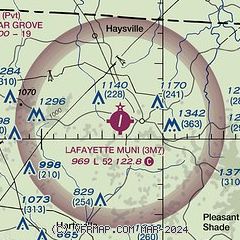
|
| Airport distance calculator |
|---|
|
|
| Sunrise and sunset |
|---|
|
Times for 18-Jun-2026
| | Local
(UTC-5) | | Zulu
(UTC) |
|---|
| Morning civil twilight | | 04:56 | | 09:56 |
| Sunrise | | 05:27 | | 10:27 |
| Sunset | | 20:04 | | 01:04 |
| Evening civil twilight | | 20:34 | | 01:34 |
|
| Current date and time |
|---|
| Zulu (UTC) | 19-Jun-2026 02:18:02 |
|---|
| Local (UTC-5) | 18-Jun-2026 21:18:02 |
|---|
|
| METAR |
|---|
KXNX
19nm SW | 190155Z AUTO 00000KT 10SM FEW060 BKN120 20/20 A2985 RMK A01 P0001
|
K1M5
21nm W | 190155Z AUTO 00000KT 10SM SCT050 SCT065 BKN075 20/20 A2983 RMK A01
|
KM54
23nm SW | 190150Z AUTO 14005KT 10SM FEW028 SCT055 BKN070 20/20 A2979 RMK A01
|
KGLW
31nm N | 190155Z AUTO 00000KT 10SM CLR 19/19 A2986 RMK AO2 T01900190
|
KBWG
32nm NW | 190153Z AUTO 00000KT 10SM CLR 21/20 A2985 RMK AO2 SLP103 T02110200
|
K8A3
37nm E | 190155Z AUTO 00000KT 10SM SCT044 SCT050 OVC060 20/19 A2986 RMK A01
|
KMQY
37nm SW | 190156Z 17003KT 10SM FEW033 SCT090 BKN110 21/ A2985 RMK AO2 SLP109 T0211
|
KSRB
38nm SE | 190155Z AUTO 00000KT 9SM -DZ BKN019 OVC027 23/23 A2985 RMK AO2
|
|
| NOTAMs |
|---|
NOTAMs are issued by the DoD/FAA and will open in a separate window not controlled by AirNav.
|
|

