FAA INFORMATION EFFECTIVE 14 MAY 2026
Location
| FAA Identifier: | 3O1 |
| Lat/Long: | 37-15-38.0000N 120-57-51.3000W
37-15.633333N 120-57.855000W
37.2605556,-120.9642500
(estimated) |
| Elevation: | 79.2 ft. / 24.1 m (surveyed) |
| Variation: | 16E (1985) |
| From city: | 2 miles E of GUSTINE, CA |
| Time zone: | UTC -7 (UTC -8 during Standard Time) |
| Zip code: | 95322 |
Airport Operations
| Airport use: | Open to the public |
| Activation date: | 04/1946 |
| Control tower: | no |
| ARTCC: | OAKLAND CENTER |
| FSS: | RANCHO MURIETA FLIGHT SERVICE STATION |
| NOTAMs facility: | RIU (NOTAM-D service available) |
| Attendance: | UNATNDD |
| Pattern altitude: | 879.2 ft. MSL |
| Wind indicator: | lighted |
| Segmented circle: | yes |
| Lights: | MIRL RWY 18/36 PRESET LOW INTST; TO INCREASE INTST ACTVT CTAF. ACTVT PAPI RWY 18 & PAPI RWY 36 CTAF 5 CLICKS. MIRL RWY 18/36 OTS INDEFLY. PAPI RWY 18 & PAPI RWY 36 OTS INDEFLY. |
| Beacon: | white-green (lighted land airport)
Operates sunset to sunrise. |
Airport Communications
| CTAF: | 122.9 |
| WX AWOS-3 at LSN (13 nm S): | 118.675 (209-827-7084) |
Nearby radio navigation aids
| VOR radial/distance | | VOR name | | Freq | | Var |
|---|
| MODr164/22.0 | | MODESTO VOR/DME | | 114.60 | | 17E |
| HYPr260/27.1 | | EL NIDO VOR/DME | | 113.85 | | 15E |
| PXNr329/33.9 | | PANOCHE VORTAC | | 112.60 | | 16E |
Airport Services
| Fuel available: | 100LL
100LL:AUTOMATED CREDIT CARD FUEL SYS 24 HRS. |
| Parking: | tiedowns |
Runway Information
Runway 18/36
| Dimensions: | 3207 x 60 ft. / 977 x 18 m |
| Surface: | asphalt, in poor condition
RWY 18/36 POOR COND WITH WEEDS GROWING IN THE ALLIGATORING, AND LONGL AND LATERAL CRACKING. |
| Weight bearing capacity: | |
| Runway edge lights: | medium intensity |
| RUNWAY 18 | | RUNWAY 36 |
| Latitude: | 37-15.887940N | | 37-15.379753N |
| Longitude: | 120-57.764983W | | 120-57.946400W |
| Elevation: | 77.8 ft. | | 79.2 ft. |
| Traffic pattern: | left | | left |
| Runway heading: | 180 magnetic, 196 true | | 000 magnetic, 016 true |
| Markings: | basic, in poor condition | | basic, in poor condition |
| Visual slope indicator: | 2-light PAPI on left (3.00 degrees glide path) | | 2-light PAPI on left (3.00 degrees glide path) |
| Runway end identifier lights: | no | | no |
| Touchdown point: | yes, no lights | | yes, no lights |
| Obstructions: | 15 ft. road, 490 ft. from runway, 155 ft. right of centerline, 19:1 slope to clear | | 35 ft. pline, 1450 ft. from runway, 530 ft. left of centerline, 36:1 slope to clear |
Airport Ownership and Management from official FAA records
| Ownership: | Publicly-owned |
| Owner: | CITY OF GUSTINE
PO BOX 16, 352 FIFTH STREET
GUSTINE, CA 95322-0016
Phone 209-854-6471 |
| Manager: | JAMI WESTERVELT
PO BOX 16, 352 FIFTH STREET
GUSTINE, CA 95322-0016
Phone 209-854-6471
CITY HALL |
Additional Remarks
| - | 675 X 50 PAVED RY SAFETY AREA AT NORTH END OF RY UNUSABLE FOR TKOF/LNDG. |
| - | BIRD ACTIVITY INVOF ARPT. |
| - | FOR CD CTC NORCAL APCH AT 916-361-0516. |
| - | ARPT CLSD AT NGT. |
| - | RWY 18/36 MARKINGS IN POOR COND; INDISTINGUISHABLE FROM TFC PAT ALT. |
Instrument Procedures
There are no published instrument procedures at 3O1.
Some nearby airports with instrument procedures:
KLSN - Los Banos Municipal Airport (13 nm S)
O15 - Turlock Municipal Airport (18 nm NE)
KMER - Castle Airport (20 nm E)
KMCE - Merced Yosemite Regional Airport (22 nm E)
KMOD - Modesto City-County Airport-Harry Sham Field (22 nm N)
|
|

Road maps at:
MapQuest
Bing
Google
| Aerial photo |
|---|
WARNING: Photo may not be current or correct
 Photo by Mike Musson
Do you have a better or more recent aerial photo of Gustine Airport that you would like to share? If so, please send us your photo.
|
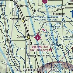
| Sectional chart |
|---|
|
| Airport distance calculator |
|---|
|
|
| Sunrise and sunset |
|---|
|
Times for 10-Jun-2026
| | Local
(UTC-7) | | Zulu
(UTC) |
|---|
| Morning civil twilight | | 05:13 | | 12:13 |
| Sunrise | | 05:44 | | 12:44 |
| Sunset | | 20:23 | | 03:23 |
| Evening civil twilight | | 20:53 | | 03:53 |
|
| Current date and time |
|---|
| Zulu (UTC) | 10-Jun-2026 19:46:39 |
|---|
| Local (UTC-7) | 10-Jun-2026 12:46:39 |
|---|
|
| METAR |
|---|
KMER
20nm E | 101855Z 32014KT 10SM CLR
|
KMOD
21nm N | 101853Z 33015G20KT 10SM CLR 30/11 A2987 RMK AO2 SLP115 T03000106
|
KMCE
22nm E | 101853Z AUTO 32007KT 300V360 10SM CLR 29/12 A2987 RMK AO2 SLP115 T02890117
|
KCVH
31nm SW | 101935Z AUTO 00000G10KT 10SM CLR 31/10 A2989 RMK A01
|
KE16
32nm W | 101930Z AUTO 34009G14KT 10SM -RA CLR 30/11 A2990 RMK AO2
|
KTCY
34nm NW | 101935Z AUTO 34009G15KT 10SM CLR 30/07 A2989 RMK A01
|
KSCK
39nm N | 101855Z 32013G18KT 10SM CLR 32/09 A2988 RMK AO2 SLP119 T03170094
|
|
| TAF |
|---|
KMOD
21nm N | 101724Z 1018/1118 30012KT P6SM SKC FM102000 32014G22KT P6SM SKC FM110300 32010KT P6SM SKC
|
KMCE
22nm E | 101720Z 1018/1118 32012KT P6SM SKC FM110300 VRB06KT P6SM SKC
|
|
| NOTAMs |
|---|
NOTAMs are issued by the DoD/FAA and will open in a separate window not controlled by AirNav.
|
|

