FAA INFORMATION EFFECTIVE 27 NOVEMBER 2025
Location
| FAA Identifier: | 46U |
| Lat/Long: | 43-10-54.5000N 111-02-18.6000W
43-10.908333N 111-02.310000W
43.1818056,-111.0385000
(estimated) |
| Elevation: | 5637 ft. / 1718.2 m (surveyed) |
| Variation: | 11E (2020) |
| From city: | 1 mile NW of ALPINE, WY |
| Time zone: | UTC -7 (UTC -6 during Daylight Saving Time) |
| Zip code: | 83128 |
Airport Operations
| Airport use: | Open to the public |
| Activation date: | 12/1971 |
| Control tower: | no |
| ARTCC: | SALT LAKE CITY CENTER |
| FSS: | CASPER FLIGHT SERVICE STATION |
| NOTAMs facility: | CPR (NOTAM-D service available) |
| Attendance: | UNATNDD |
| Wind indicator: | yes |
| Segmented circle: | no |
| Lights: | ACTVT PAPI RWY 13; MIRL RWY 13/31 - CTAF |
| Landing fee: | yes, FEES IMPOSED FOR LDG OVNGT OR EXTDD STAY PRKG. RAMP & PRKG SPACE VERY LTD SPCLY IN THE WINTER. |
Airport Communications
| CTAF: | 122.9 |
| WX AWOS-3: | 119.925 (307-654-2004) |
Nearby radio navigation aids
| VOR radial/distance | | VOR name | | Freq | | Var |
|---|
| JACr194/29.6 | | JACKSON VOR/DME | | 115.40 | | 13E |
Airport Services
| Fuel available: | 100LL JET-A
A:24 HR SELF SVC FUEL AVBL WITH CREDIT CARD; FULL SVC JET A & AVGAS ALSO AVBL ARNGD IN ADVN PHONE 307-654-4646. |
| Parking: | tiedowns |
| Airframe service: | NONE |
| Powerplant service: | NONE |
| Bottled oxygen: | NONE |
| Bulk oxygen: | NONE |
Runway Information
Runway 13/31
| Dimensions: | 5827 x 70 ft. / 1776 x 21 m |
| Surface: | asphalt, in good condition |
| Weight bearing capacity: | |
| Runway edge lights: | medium intensity |
| RUNWAY 13 | | RUNWAY 31 |
| Latitude: | 43-11.286988N | | 43-10.529475N |
| Longitude: | 111-02.712137W | | 111-01.908645W |
| Elevation: | 5624.4 ft. | | 5636.9 ft. |
| Traffic pattern: | right | | left |
| Runway heading: | 131 magnetic, 142 true | | 311 magnetic, 322 true |
| Displaced threshold: | no | | 466 ft. |
| Markings: | nonprecision, in good condition | | nonprecision, in good condition |
| Visual slope indicator: | 2-light PAPI on left (3.00 degrees glide path) | | |
| Touchdown point: | yes, no lights | | yes, no lights |
| Obstructions: | none
+3 FT VEGETATION & +5 FT DROP 60 FT FROM RWY END ACRS BOTH SIDES OF CNTRLN. | | 19 ft. road, 200 ft. from runway, 1:1 slope to clear
16 FT PAVED ROAD 106 FT FM RWY END CROSSES RWY END. |
Airport Ownership and Management from official FAA records
| Ownership: | Privately-owned |
| Owner: | ALPINE AIRPARK, LLC
592 AIRPORT DRIVE, UNIT 3
ALPINE, WY 83128
Phone 307-654-4646 |
| Manager: | LYNN FERGUSON
PO BOX 3386
ALPINE, WY 83128
Phone 307-654-4646 |
Additional Remarks
| A30A-31 | RWY 13/31 FENCES, BLDGS & TREES WI 150 FT N & S OF CNTRLN. |
| - | ARPT CLSD NGTS |
| - | AVOID LOW LEVEL FLT OVER CITY OR EAST OF RWY, |
| - | NOISE SENS ARPT WX PMTG LND RWY 13 TKOF RWY 31 FOR NOISE ABATEMENT; DUE TO THE PROXIMITY OF THE TOWN OF ALPINE & ARPT HOUSING; TOUCH & GOES ARE PROHIBITED. |
| - | RESIDENTIAL TWYS ESTAB THEIR OWN WT LMTS & RQR APVL PRIOR TO USE. |
| - | FOR CD CTC SALT LAKE ARTCC AT 801-320-2568. |
| - | TSNT TFC MUST CTC THE AMGR FOR INFO ON UNIQUE LCL FLYING OPNS BFR USING THE ARPT. |
| - | VOLUNTARY CURFEW DUSK TO DAWN. NGT LDGS LMTD TO AIRPARK RESIDENTS ONLY. NGT TIME LDGS AND TKFS NOT ADVS TO PILOTS UNFAMILIAR WITH TRRN. WILDLIFE ON AND INVOF OF ARPT. BIRD/WATERFOWL HAZ. |
| - | FOR RWY COND IN WINTER CTC - AMGR. |
| - | VRB RWY COND AND BA WINTER MOS. SNBNK ALG RWY & TWY EDGES POSS FALL, WINT, SPRING MOS. TREACHEROUS MTN TERR IN CLOSE PROXIMITY ALL QUADS OF RWY. |
Instrument Procedures
There are no published instrument procedures at 46U.
Some nearby airports with instrument procedures:
KAFO - Afton Lincoln County Airport/General Boyd L Eddins Field (29 nm S)
KJAC - Jackson Hole Airport (29 nm NE)
KDIJ - Driggs/Reed Memorial Airport (34 nm N)
KIDA - Idaho Falls Regional Airport (49 nm NW)
KRXE - Rexburg-Madison County Airport (51 nm NW)
|
|

Road maps at:
MapQuest
Bing
Google
| Aerial photo |
|---|
WARNING: Photo may not be current or correct
 Photo taken 25-Sep-2018
looking north-northwest.
Photo taken 25-Sep-2018
looking north-northwest.
Do you have a better or more recent aerial photo of Alpine Airport that you would like to share? If so, please send us your photo.
|
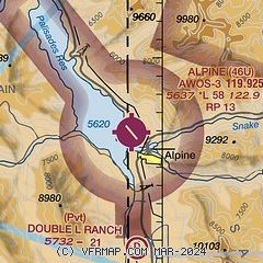
| Sectional chart |
|---|
|
| Airport distance calculator |
|---|
|
|
| Sunrise and sunset |
|---|
|
Times for 18-Dec-2025
| | Local
(UTC-7) | | Zulu
(UTC) |
|---|
| Morning civil twilight | | 07:20 | | 14:20 |
| Sunrise | | 07:52 | | 14:52 |
| Sunset | | 16:49 | | 23:49 |
| Evening civil twilight | | 17:22 | | 00:22 |
|
| Current date and time |
|---|
| Zulu (UTC) | 18-Dec-2025 20:44:54 |
|---|
| Local (UTC-7) | 18-Dec-2025 13:44:54 |
|---|
|
| METAR |
|---|
| K46U | 182035Z AUTO 00000KT 4SM HZ CLR M03/ A3009 RMK A01
|
|
| TAF |
|---|
KJAC
29nm NE | 181720Z 1818/1918 21012G18KT 3SM -SN SCT008 BKN015 OVC025 FM182300 21015G25KT 1SM -SN SCT005 OVC015 FM191100 22020G30KT P6SM VCSH OVC050 FM191400 22020G35KT 3SM -SN SCT015 OVC025
|
KDIJ
34nm N | 181726Z 1818/1918 18010G20KT 3SM -SHSN SCT012 OVC025 TEMPO 1818/1822 1SM -SN BKN012 OVC020 FM182200 18010G20KT 1SM -SN OVC012 FM190300 20015G25KT 5SM -SHSN SCT012 OVC030 FM191600 21020G30KT 3SM -SN SCT008 OVC020 AMD LTD TO CLD VIS AND WIND
|
|
| NOTAMs |
|---|
NOTAMs are issued by the DoD/FAA and will open in a separate window not controlled by AirNav.
|
|

