FAA INFORMATION EFFECTIVE 09 JULY 2026
Location
| FAA Identifier: | 4B7 |
| Lat/Long: | 43-51-45.2862N 073-44-25.9700W
43-51.754770N 073-44.432833W
43.8625795,-73.7405472
(estimated) |
| Elevation: | 834.2 ft. / 254 m (estimated) |
| Variation: | 15W (1985) |
| From city: | 2 miles N of SCHROON LAKE, NY |
| Time zone: | UTC -4 (UTC -5 during Standard Time) |
| Zip code: | 12870 |
Airport Operations
| Airport use: | Open to the public |
| Activation date: | 09/1966 |
| Control tower: | no |
| ARTCC: | BOSTON CENTER |
| FSS: | BURLINGTON FLIGHT SERVICE STATION |
| NOTAMs facility: | BTV (NOTAM-D service available) |
| Attendance: | UNATNDD, ALL DAYLIGHT HOURS |
| Wind indicator: | yes |
| Segmented circle: | no |
Airport Communications
Nearby radio navigation aids
| NDB name | | Hdg/Dist | | Freq | | Var | | ID |
|---|
| SMUTO | | 300/35.2 | | 221 | | 15W | | DYO | -.. -.-- --- |
Airport Services
| Parking: | tiedowns |
| Airframe service: | NONE |
| Powerplant service: | NONE |
| Bottled oxygen: | NONE |
| Bulk oxygen: | NONE |
Runway Information
Runway 16/34
| Dimensions: | 3000 x 60 ft. / 914 x 18 m |
| Surface: | asphalt, in good condition |
| Weight bearing capacity: | |
| RUNWAY 16 | | RUNWAY 34 |
| Traffic pattern: | left | | left |
| Displaced threshold: | 100 ft. | | no |
| Markings: | basic, in good condition | | basic, in good condition |
| Runway end identifier lights: | no | | no |
| Obstructions: | 15 ft. road, 200 ft. from runway
RWY 16 HAS +15 FT ROAD, PARL TO RWY, 65 FT RIGHT. +42 FT TREE, 169 FT FM RWY, 108 FT LEFT. | | 66 ft. trees, 301 ft. from runway, 108 ft. right of centerline, 1:1 slope to clear
RWY 34 HAS +15 FT TRRN, 0 TO 200 FT FM RWY END, 40 FT RIGHT. |
Airport Ownership and Management from official FAA records
| Ownership: | Publicly-owned |
| Owner: | TOWN OF SCHROON LAKE
SCHROON LAKE, NY 12870
Phone 518-532-7737 |
| Manager: | TOWN SUPERVISOR
C/O TOWN OF SCHROON LAKE
SCHROON LAKE, NY 12870
Phone 518-532-7737
FOR SVC CALL MGR PHONE 518-532-7737 X11 OR 518-532-7878. |
Additional Remarks
| - | DEBRIS FM ADJACENT LAND FILL IS OCCASIONALLY BLOWN ONTO AND ACROSS RY. |
| - | RECOMMENDED LDG RY 16, TKOF RY 34. |
| - | FOR CD CTC BOSTON ARTCC AT 603-879-6859. |
| - | 25 FT DROPOFF 30 FT FM PAVEMENT AER 34. |
Instrument Procedures
There are no published instrument procedures at 4B7.
Some nearby airports with instrument procedures:
4B6 - Ticonderoga Municipal Airport (14 nm E)
KLKP - Lake Placid Airport (26 nm N)
KGFL - Floyd Bennett Memorial Airport (32 nm S)
KSLK - Adirondack Regional Airport (37 nm NW)
KRUT - Rutland/Southern Vermont Regional Airport (40 nm SE)
|
|

Road maps at:
MapQuest
Bing
Google
| Aerial photo |
|---|
WARNING: Photo may not be current or correct

Do you have a better or more recent aerial photo of Schroon Lake Airport that you would like to share? If so, please send us your photo.
|
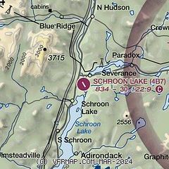
| Sectional chart |
|---|
|
| Airport distance calculator |
|---|
|
|
| Sunrise and sunset |
|---|
|
Times for 26-Jul-2026
| | Local
(UTC-4) | | Zulu
(UTC) |
|---|
| Morning civil twilight | | 05:04 | | 09:04 |
| Sunrise | | 05:38 | | 09:38 |
| Sunset | | 20:25 | | 00:25 |
| Evening civil twilight | | 20:58 | | 00:58 |
|
| Current date and time |
|---|
| Zulu (UTC) | 26-Jul-2026 22:59:33 |
|---|
| Local (UTC-4) | 26-Jul-2026 18:59:33 |
|---|
|
| METAR |
|---|
KLKP
26nm N | 262235Z AUTO 34009KT 10SM BKN060 OVC075 24/15 A2988 RMK AO2 LTG DSNT W
|
K6B0
29nm E | 262235Z AUTO 17004KT 10SM CLR 25/14 A2984 RMK AO2 LTG DSNT W AND NW T02470137
|
KSLK
38nm NW | 262251Z AUTO 23004KT 7SM -RA OVC100 18/17 A2988 RMK AO2 LTG DSNT SW AND W RAB06 SLP117 P0003 T01830172
|
KRUT
40nm SE | 262156Z AUTO 18004KT 10SM CLR 24/17 A2986 RMK AO2 SLP104 T02390167
|
KBTV
44nm NE | 262254Z 19005KT 10SM SCT100 BKN200 27/14 A2981 RMK AO2 SLP094 T02720139
|
KPBG
49nm N | 262153Z AUTO 15011KT 10SM CLR 28/13 A2979 RMK AO2 SLP088 T02780133 $
|
|
| TAF |
|---|
KGFL
32nm S | 261720Z 2618/2718 18006KT P6SM SCT060 SCT250 FM270000 00000KT P6SM BKN080 FM270900 00000KT P6SM FEW080 FEW250 TEMPO 2709/2711 2SM BR FM271600 17006KT P6SM SCT060 SCT250 AMD NOT SKED
|
KSLK
38nm NW | 261734Z 2618/2718 VRB03KT P6SM BKN150 PROB30 2619/2623 3SM -TSRA BKN050CB FM271100 15006KT P6SM FEW090
|
KRUT
40nm SE | 261734Z 2618/2718 00000KT P6SM SCT170 FM270200 12006KT P6SM FEW100 FM271200 VRB03KT P6SM FEW100
|
|
| NOTAMs |
|---|
NOTAMs are issued by the DoD/FAA and will open in a separate window not controlled by AirNav.
|
|

