FAA INFORMATION EFFECTIVE 17 APRIL 2025
Location
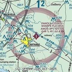
| FAA Identifier: | 4F2 |
| Lat/Long: | 32-10-33.9000N 094-17-55.7000W
32-10.565000N 094-17.928333W
32.1760833,-94.2988056
(estimated) |
| Elevation: | 248 ft. / 75.6 m (surveyed) |
| Variation: | 04E (1995) |
| From city: | 2 miles E of CARTHAGE, TX |
| Time zone: | UTC -5 (UTC -6 during Standard Time) |
| Zip code: | 75633 |
Airport Operations
| Airport use: | Open to the public |
| Activation date: | 09/1963 |
| Control tower: | no |
| ARTCC: | FORT WORTH CENTER |
| FSS: | FORT WORTH FLIGHT SERVICE STATION |
| NOTAMs facility: | FTW (NOTAM-D service available) |
| Attendance: | MON-FRI 0800-1700 |
| Wind indicator: | lighted |
| Segmented circle: | yes |
| Lights: | MIRL RWY 17/35 PRESET LOW INTST; TO INCR INTST ACTVT - CTAF. PAPI OPR CONSLY. |
| Beacon: | white-green (lighted land airport)
Operates sunset to sunrise. |
Airport Communications
| CTAF/UNICOM: | 122.8 |
| WX AWOS-3PT: | 121.125 (903-690-0511) |
| SHREVEPORT APPROACH: | 119.9 |
| SHREVEPORT DEPARTURE: | 119.9 |
Nearby radio navigation aids
| VOR radial/distance | | VOR name | | Freq | | Var |
|---|
| GGGr115/27.2 | | GREGG COUNTY VORTAC | | 112.90 | | 07E |
| EMGr242/38.1 | | ELM GROVE VORTAC | | 116.65 | | 07E |
| NDB name | | Hdg/Dist | | Freq | | Var | | ID |
|---|
| AMASON | | 336/21.9 | | 341 | | 04E | | CZJ | -.-. --.. .--- |
Airport Services
| Fuel available: | 100LL
100LL:FUEL 24 HRS SELF-SERVE. |
| Parking: | tiedowns |
| Bottled oxygen: | NONE |
| Bulk oxygen: | NONE |
Runway Information
Runway 17/35
| Dimensions: | 4000 x 75 ft. / 1219 x 23 m |
| Surface: | asphalt, in fair condition |
| Runway edge lights: | medium intensity |
| RUNWAY 17 | | RUNWAY 35 |
| Latitude: | 32-10.894252N | | 32-10.235000N |
| Longitude: | 094-17.943713W | | 094-17.913840W |
| Elevation: | 244.1 ft. | | 248.0 ft. |
| Traffic pattern: | left | | left |
| Runway heading: | 174 magnetic, 178 true | | 354 magnetic, 358 true |
| Markings: | nonprecision, in fair condition | | nonprecision, in fair condition |
| Visual slope indicator: | 4-light PAPI on left (3.00 degrees glide path) | | 4-light PAPI on left (4.00 degrees glide path) |
| Touchdown point: | yes, no lights | | yes, no lights |
| Obstructions: | 104 ft. trees, 3205 ft. from runway, 28:1 slope to clear | | 80 ft. trees, 1900 ft. from runway, 100 ft. right of centerline, 21:1 slope to clear |
Airport Ownership and Management from official FAA records
| Ownership: | Publicly-owned |
| Owner: | PANOLA CO
PANOLA CO. COURTHOUSE
CARTHAGE, TX 75633
Phone 903-693-0391 |
| Manager: | ROBERT DUNCAN
1305 HIGHWAY 79 NORTH
CARTHAGE, TX 75633
Phone 903-693-7856
MGR CELL 903-690-2833, SHERIFF OFC 903-693-0333. |
Additional Remarks
| - | DEER ON & INVOF RWY. |
| - | FOR CD CTC FORT WORTH ARTCC AT 817-858-7584. |
Instrument Procedures
NOTE: All procedures below are presented as PDF files. If you need a reader for these files, you should download the free Adobe Reader.NOT FOR NAVIGATION. Please procure official charts for flight.
FAA instrument procedures published for use from 17 April 2025 at 0901Z to 15 May 2025 at 0900z.
IAPs - Instrument Approach Procedures |
|---|
| RNAV (GPS) RWY 17 | |
download (172KB) |
| RNAV (GPS) RWY 35 | |
download (184KB) |
| NOTE: Special Alternate Minimums apply | |
download (137KB) |
Other nearby airports with instrument procedures:
KASL - Harrison County Airport (21 nm N)
F17 - Center Municipal Airport (22 nm S)
KGGG - East Texas Regional Airport (24 nm NW)
3F3 - C E 'Rusty' Williams Airport (28 nm E)
KRFI - Rusk County Airport (28 nm W)
|
|

Road maps at:
MapQuest
Bing
Google
| Aerial photo |
|---|
WARNING: Photo may not be current or correct
 Photo taken 28-Jan-2018
looking south from 4,500 ft.
Photo taken 28-Jan-2018
looking south from 4,500 ft.
Do you have a better or more recent aerial photo of Panola County Airport-Sharpe Field that you would like to share? If so, please send us your photo.
|
| Sectional chart |
|---|
|
| Airport distance calculator |
|---|
|
|
| Sunrise and sunset |
|---|
|
Times for 05-May-2025
| | Local
(UTC-5) | | Zulu
(UTC) |
|---|
| Morning civil twilight | | 06:02 | | 11:02 |
| Sunrise | | 06:28 | | 11:28 |
| Sunset | | 20:00 | | 01:00 |
| Evening civil twilight | | 20:26 | | 01:26 |
|
| Current date and time |
|---|
| Zulu (UTC) | 06-May-2025 02:46:49 |
|---|
| Local (UTC-5) | 05-May-2025 21:46:49 |
|---|
|
| METAR |
|---|
| K4F2 | 060235Z AUTO 00000KT 10SM SCT110 17/16 A2991 RMK AO2 LTG DSNT S T01680160
|
|
| TAF |
|---|
KGGG
25nm NW | 051720Z 0518/0618 12006KT P6SM BKN250 FM052100 11007KT P6SM SCT080 BKN250 FM060100 10004KT P6SM FEW035 BKN080 OVC120 FM060600 11006KT P6SM VCSH BKN035 OVC070 FM061200 10010KT 6SM -RA OVC025
|
KSHV
29nm NE | 051720Z 0518/0618 13006KT P6SM FEW100 BKN250 FM060000 12005KT P6SM SCT090 BKN180 BKN250 FM060600 10004KT P6SM BKN040 OVC080 FM061200 10006KT P6SM VCSH OVC050
|
|
| NOTAMs |
|---|
NOTAMs are issued by the DoD/FAA and will open in a separate window not controlled by AirNav.
|
|


